Jared Smith founded @chswx on Twitter in 2008 as an experiment in disseminating weather data through social media. In the ensuing decade-and-a-half, @chswx has provided live coverage of tropical cyclones, tornadoes, severe weather, and even a couple bouts of winter weather to the good people of Charleston, SC.
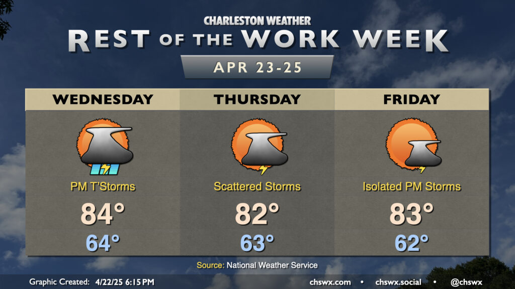
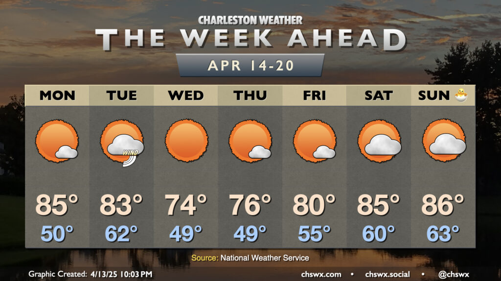
The rest of the work week will be a bit on the unsettled side, especially Wednesday into Thursday, as a stalling front combines with some mid-level energy that’ll be working through the area. Wednesday starts generally quiet with lows in the mid-60s, but showers and thunderstorms should generally fill in starting in the early to mid-afternoon hours as temperatures peak in the mid-80s. Locally heavy rain will be possible, and a strong storm or two with hail and gusty winds can’t be ruled out, especially inland. Keep an eye out just in case, and be ready for evening commute slowdowns.
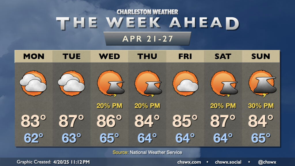
We’ve got another warm and generally quiet day of weather inbound for Tuesday. Temperatures will, in fact, run a little warmer than they did on Monday despite some additional cloud cover as high pressure aloft begins to break down. Expect generally mid-80s in the metro after a mild start in the mid-60s — temperatures that are climatologically much more in line with early June than they are late April.
A stray shower can’t be totally ruled out as the seabreeze pushes inland, but otherwise, most of us should have one more rain-free day across the area.
The last full week of April will run rather warm, with 80s throughout. A few storms will be possible midweek and again over the weekend, but no widespread drought relief is expected.
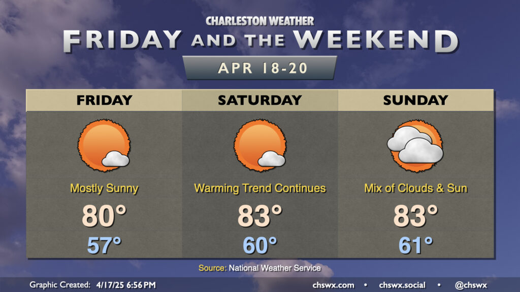
Not much to write home about in the weather department as we head into Friday and Easter weekend as temperatures warm into the 80s and precipitation remains at bay for at least a few more days as high pressure continues to be the dominant weather feature.
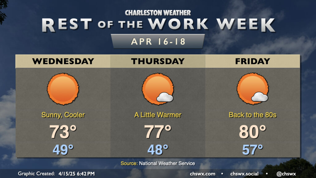
Friday starts much warmer than Thursday did, with lows in the mid-to-upper 50s to start the day warming to around 80° in the afternoon under mostly sunny skies. We turn a few degrees warmer on Saturday before the temperature curve levels out a little bit on Easter Sunday as we start to see high pressure begin to slip away a bit ahead of a front. This will help cloud cover tick up across the area, though we will still have more than ample sunshine. Enjoy!
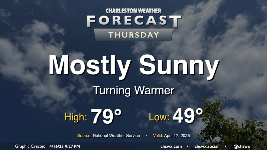
Above-normal temperatures return to the Lowcountry on Thursday as high pressure at the surface begins to head eastward. We’ll start the day in the upper 40s to around 50°, warming to near 80° in the afternoon under mostly sunny skies. I hope you get a chance to get out and about at some point because it should be another nice day!
After a cold front clears the area this evening, quiet weather will be the main story through Easter weekend. In the wake of the front, Wednesday will run about 10° cooler than Tuesday did as cooler and drier air moves in. Lows bottom out in the upper 40s, while highs peak right in the low to mid-70s, generally a few degrees below April 16 norms. It’ll be much less windy, thankfully, with winds generally 5-10 MPH.
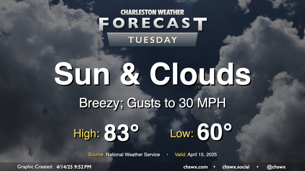
Another warm day is on tap for Tuesday ahead of a cold front that’ll push through later in the afternoon. We’ll start the day around 60°, warming to the low to mid-80s in the afternoon despite increasing cloud cover with the frontal passage. A dearth of deep moisture, though, will keep any rain at bay. It’ll be a breezy day ahead of the front, with gusts pushing 30 MPH at times, so you’ll want to keep that in mind as the bridges may be a little trickier than normal as a result. Winds will calm down in the evening once the front is by, though.
A generally quiet and warm week of weather (with a brief cooldown in the middle) lies ahead as we approach Easter, well-timed for spring break for Berkeley and Charleston’s school districts.
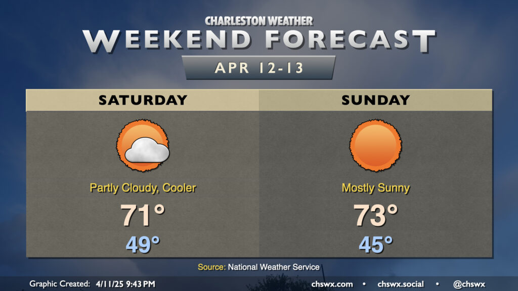
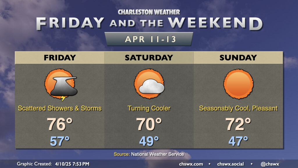
After a few thunderstorms rolled through with small hail and rainbows, we’ve got a quieter and cooler couple days teed up for the weekend as high pressure takes control. Saturday starts in the upper 40s, and we’ll warm to just the low 70s in the afternoon under partly cloudy skies. I wouldn’t totally rule out a shower in there somewhere, but the vast majority of us should get Saturday in without any precipitation issues.
Sunday will start a little cooler but end up a little warmer with brilliant sunshine expected. We start the day in the mid-40s, warming to the low to mid-70s in the afternoon, with humidity remaining low and comfortable throughout. All in all, a pretty enjoyable weekend of weather is coming up — hope you can take advantage!
Unsettled weather makes a brief return to the area overnight into Friday as a cold front works its way toward the coast. We’ll start the day on the mild — and perhaps the wet — side as temperatures bottom out just to around the mid-to-upper 50s. We’ll warm to the mid-70s in the afternoon with scattered showers and thunderstorms continuing to affect the area. Severe weather looks highly unlikely at this stage with meager instability, thankfully. Showers and thunderstorms will end by evening as the front moves by, setting the stage for a cool but quiet weekend.