The week ahead: Temperature rollercoaster rolls on
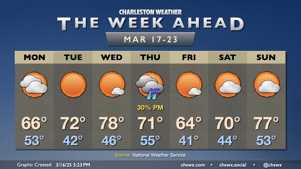
Up-and-down temperatures will be the main weather story this week, with the only shower chance coming later Thursday as another front moves by.
Read more »Up-and-down temperatures will be the main weather story this week, with the only shower chance coming later Thursday as another front moves by.
Read more »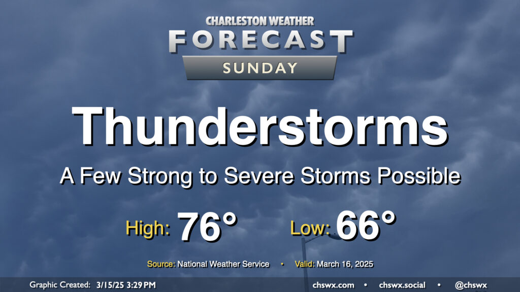
The main weather story for Sunday will be the risk for strong to severe thunderstorms in association with a squall line moving through the area generally from the mid-morning through mid-afternoon hours. Damaging wind gusts will be the overriding concern, but a tornado or two cannot be discounted, nor can some sporadic hail reports be discounted as well.
Read more »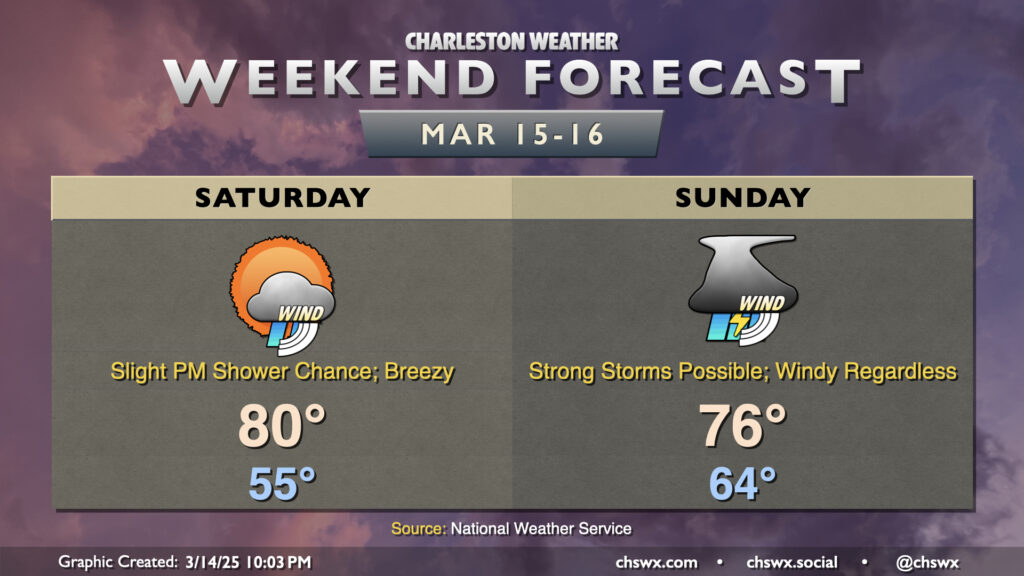
Breezy conditions continue this weekend ahead of a strong storm system that’s working its way across the midsection of the country over the next day or so, which could bring some strong storms to the area on Sunday.
Read more »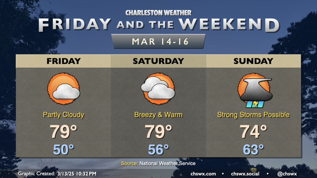
Warm weather continues for Friday and the weekend ahead of our next storm system on Sunday, which could bring us a round of strong to severe thunderstorms.
Read more »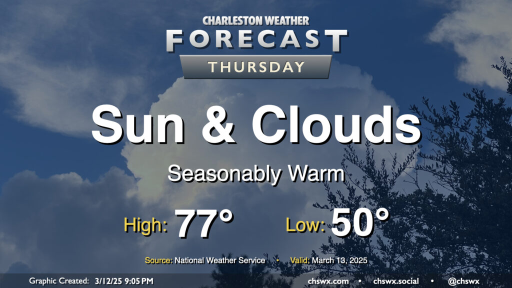
We’ll see a few more clouds on Thursday as a shortwave trough swings through aloft, but other than a slight downtick in temperatures compared to Wednesday’s highs in the low 80s, we’ll remain seasonably warm as surface high pressure remains anchored in the Atlantic for one more day. We’ll keep an eye on the moisture profiles to make sure that no showers try to overachieve with the upper-level energy moving by, but the expectation is that it’ll just be too dry for much more than the enhanced cloud cover.
Read more »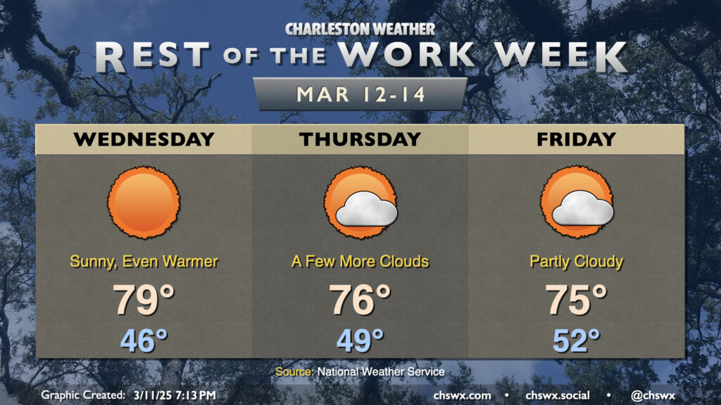
We’ll continue this benign stretch of weather for the rest of the work week, but as we head into the weekend, we’ll need to keep an eye on a storm system that could bring another round of rain and thunderstorms for Sunday.
Read more »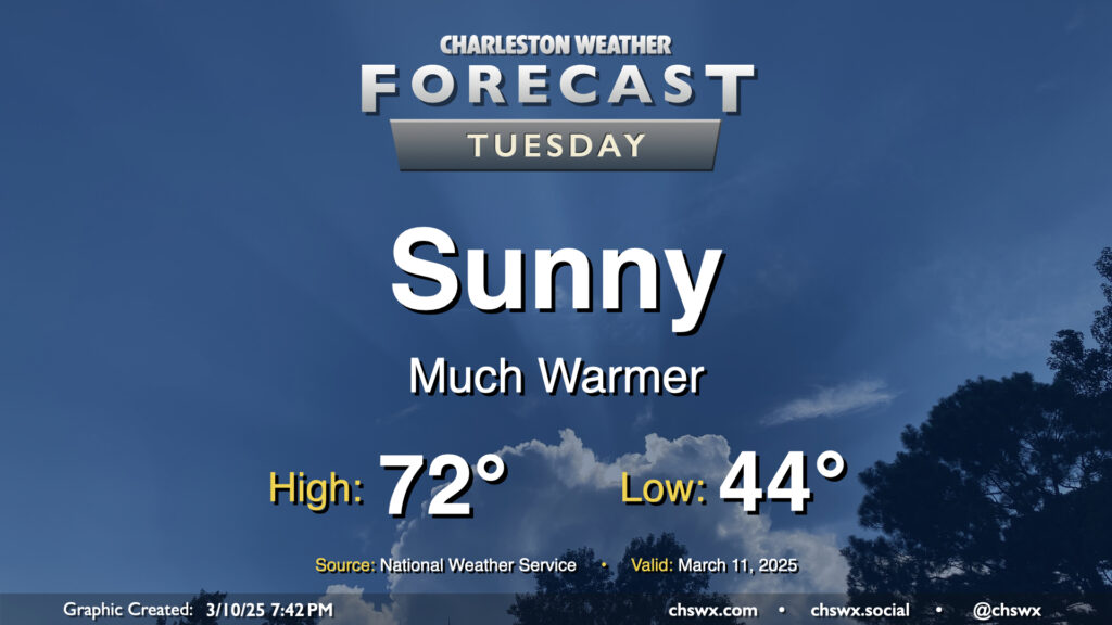
Much more sunshine is in store for Tuesday as low pressure pulls away from the area at the surface and aloft. This will help warm things up, too — after a mid-40s start, downslope winds out of the northwest and the aforementioned sunshine will push highs to the low 70s in the afternoon, a couple degrees above normal for March 11. Overall, a much nicer day than Monday (weather-wise, anyway).
Read more »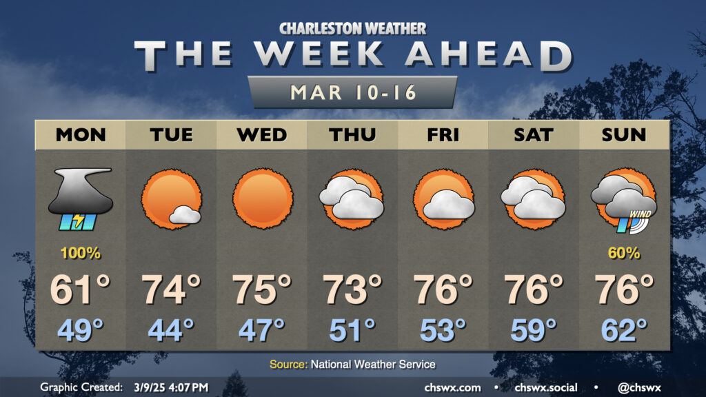
The week ahead starts on an unsettled note, but turns fairly quiet for a few days with a warm stretch of weather featuring temperatures several degrees above normal.
Read more »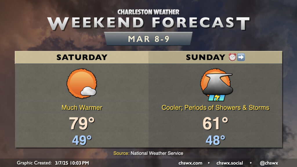
The weekend’s forecast will revolve around a cold front that’ll backdoor into the area, bringing very different weather each day. Ahead of that front, it’s going to turn much warmer — expect to start Saturday near 50°, warming to near 80° in the afternoon under partly cloudy to mostly sunny skies. As the front gets closer, we will start to see cloud cover tick up, with rain chances following early Sunday morning — quite possibly after we all spring forward an hour back into Daylight Saving Time. The front will cross through the area Sunday morning, and cooler air filtering in behind it will keep high temperatures 15-20° cooler than Saturday. We should see primarily cloud cover and periods of showers and maybe even a few thunderstorms as the front stalls to our south. There’s some disagreement in the models over just how wet of a Sunday we might have, so don’t totally write it off as a washout. However, it’s pretty clear that Saturday will be the pick day for outdoor activities with more sunshine and warmer temperatures.
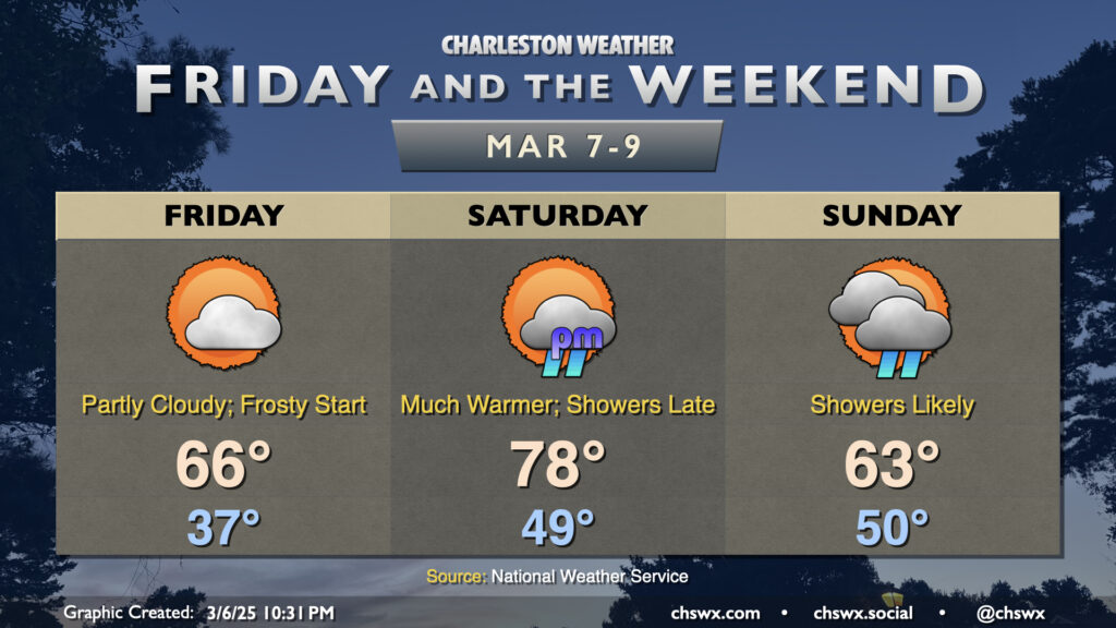
The temperature rollercoaster heads for a dip overnight tonight into Friday morning as temperatures bottom out in the mid-30s across much of the area. This could lead to some frost formation especially in rural, inland areas; a Frost Advisory is up for inland Berkeley and Dorchester as a result. We’ll warm to the mid-60s in the afternoon under partly cloudy to mostly sunny skies, though we should see a little uptick in cloud cover in the evening.
Read more »