Jared Smith founded @chswx on Twitter in 2008 as an experiment in disseminating weather data through social media. In the ensuing decade-and-a-half, @chswx has provided live coverage of tropical cyclones, tornadoes, severe weather, and even a couple bouts of winter weather to the good people of Charleston, SC.
After a record-breaking stretch of warmth over the past few days, we turn much cooler and cloudier for Monday as a backdoor front slides south and cooler high pressure wedges into the area in its wake. We could see some showers in the morning, but otherwise expect a mostly overcast day as lows in the mid-50s only warm a few degrees, perhaps not even cracking 60° in the afternoon. This stands in stark contrast to the record high of 84° set on Sunday, smashing the previous record for the date of 80° set in 1949. And while it’s been easy to forget with such warm weather, it is still February, and these things happen.
It was an incredibly warm February day in the Lowcountry, skipping ahead from a spring preview to an early summer preview as the high topped out around 84° at the airport. This high temperature obliterated the old daily record of 80° set in 2019, and was 22° above normal for February 7.
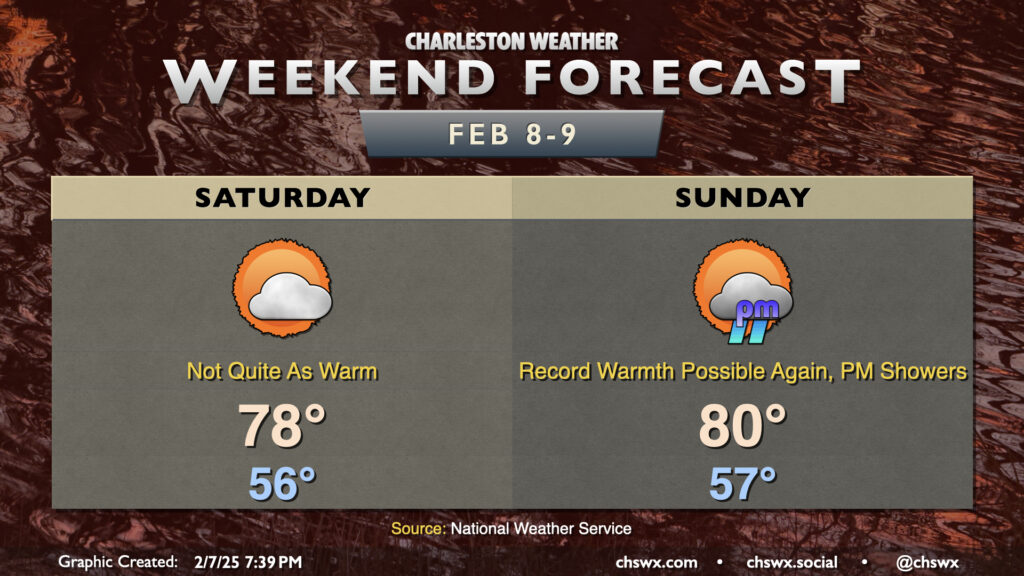
Record warmth will remain possible this weekend, especially on Sunday, before temperatures moderate (but remain above normal) as the pattern turns a little more unsettled for next week.
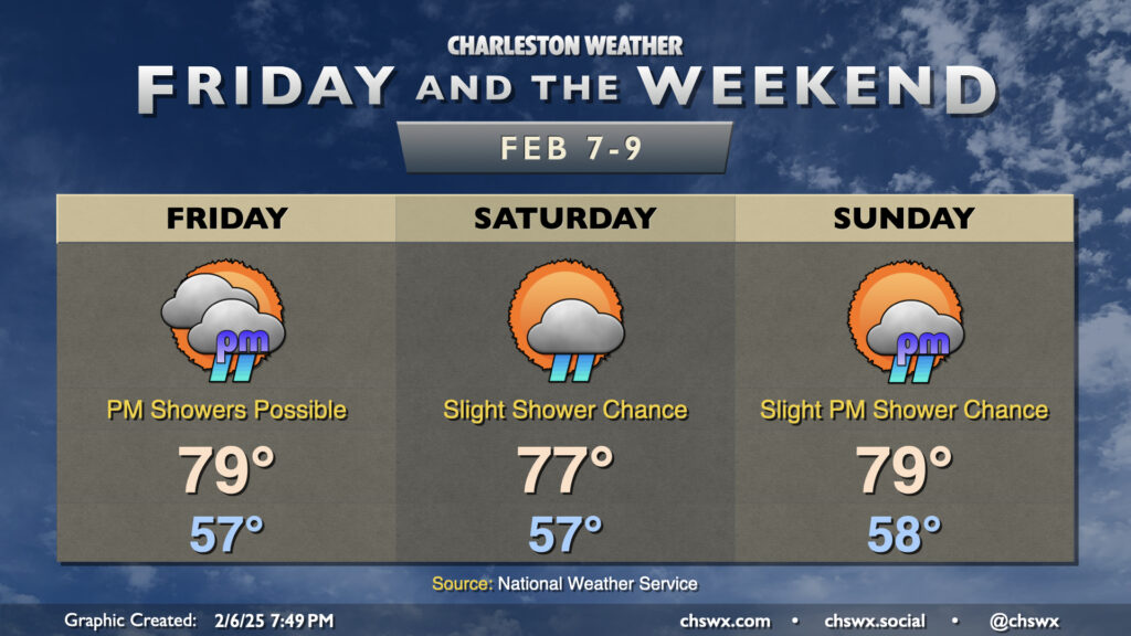
Abnormally warm weather continues for Friday and the weekend as warm high pressure continues to rule the roost for a few more days. We will have a front stall out nearby on Friday; while we’ll be on the warm side of the frontal zone, there’s still a risk for some isolated to scattered showers at time especially getting into the afternoon. A rumble of thunder isn’t totally out of the question, either. Despite the slight risk of showers, temperatures should still head into the upper 70s, threatening February 7’s daily record high of 80° set in 2019.
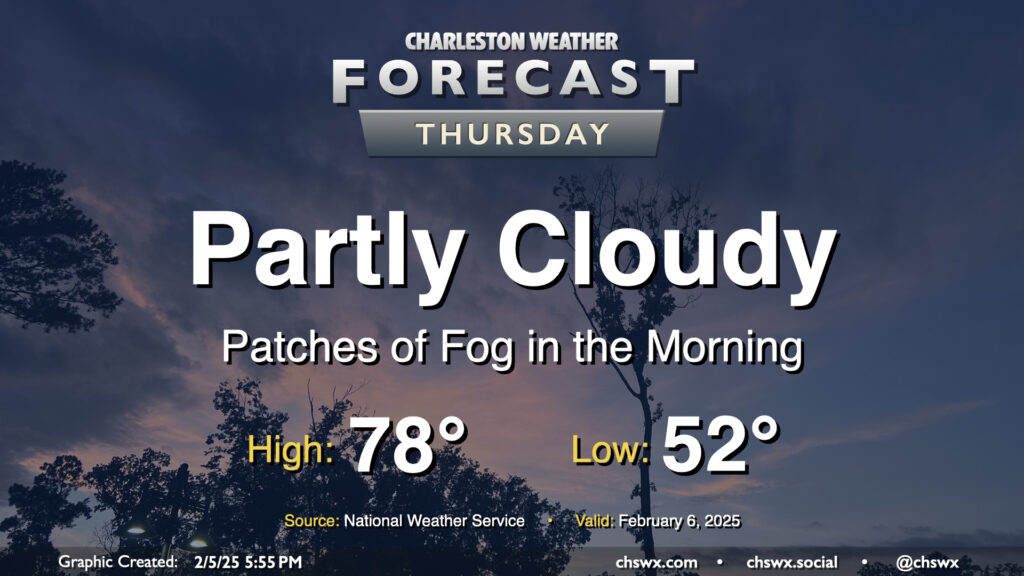
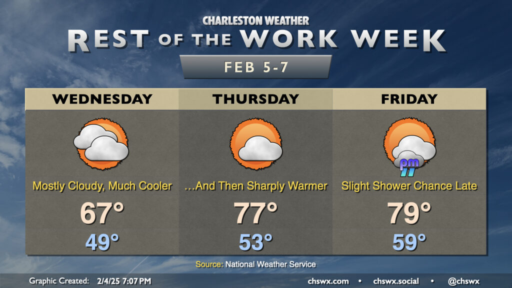
Record warmth will be possible once again Thursday as the wedge of high pressure that cooled us off on Wednesday — highs only topped out around 70° as opposed to 82° the day before — retreats northward as a warm front moves through Thursday morning. This will help disperse the cloud cover throughout the day, and temperatures should respond nicely by heading into the upper 70s. The forecast currently calls for at least tying the record high of 78° set in 2019, so we’ll see how that ends up working out.
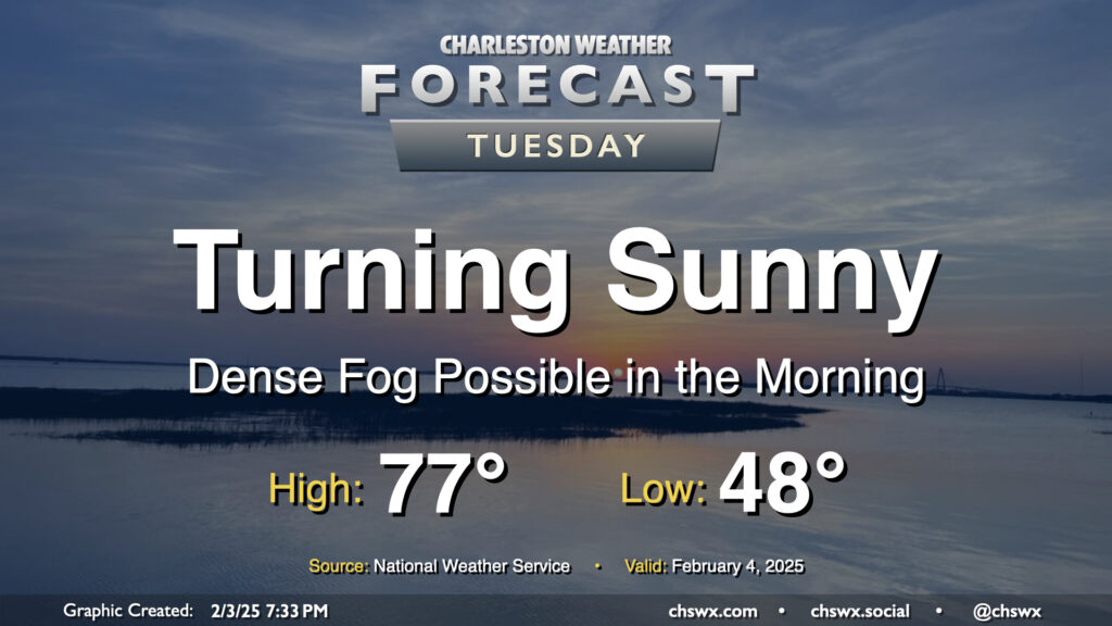
We got very close to tying a record high at the airport on Tuesday as temperatures soared to the low 80s for the first time in 2025. Don’t let your hoodies walk too far, though — high pressure wedging southward will bring much cooler and cloudier conditions for Wednesday. After starting in the upper 40s to around 50°, expect temperatures to only head to the mid-to-upper 60s in the afternoon — a pretty stark contrast to getting into the 80s, that’s for sure.
Sea fog will come ashore overnight and cause visibility issues especially near the Highway 17 corridor and points east. A Dense Fog Advisory will be in effect from 8PM Monday to 9AM Tuesday as a result. Use those low beams and allow plenty of space between you and the car in front of you.
Winds will go westerly and pick up after sunrise, which should escort the sea fog back offshore for the most part. This will allow temperatures to soar into the mid-to-upper 70s in the afternoon under mostly sunny skies. The exception will be at the immediate coast, where the seabreeze will help keep much cooler temperatures as well as continued sea fog in place. So, if you’re thinking “early February beach day,” just keep in mind that you’ll probably not be getting much sunshine.
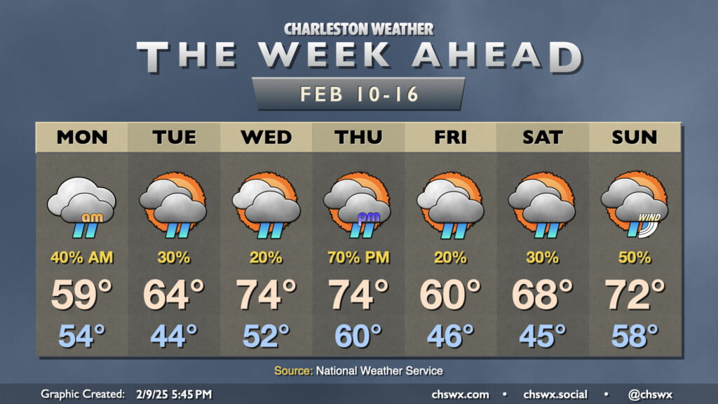
A mostly quiet week of weather lies ahead across the Tri-County area with high pressure aloft contributing to some of the warmest weather thus far in 2025.
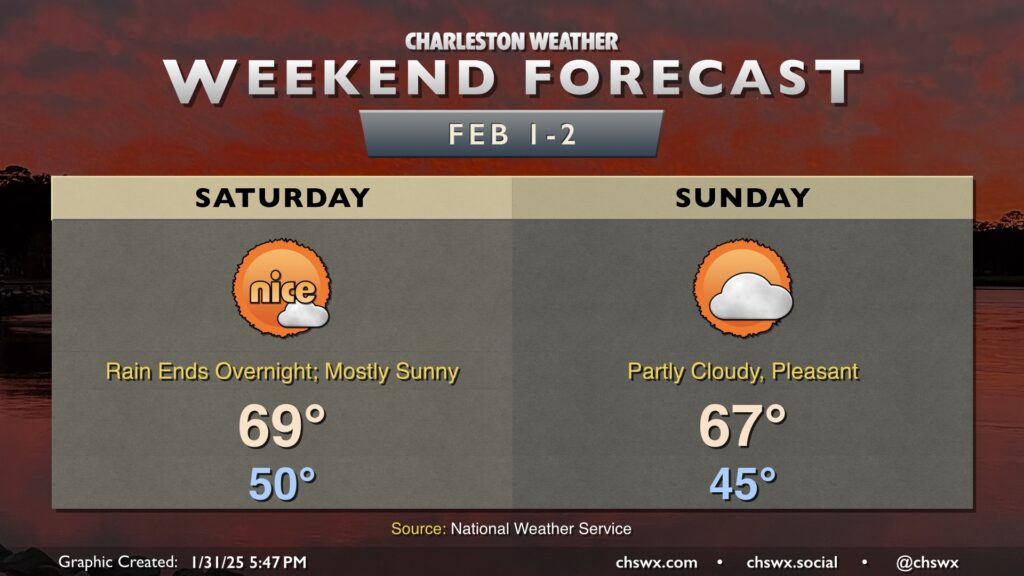
This weekend’s weather is looking pretty good in the wake of a front that will move by early Saturday. A few showers are possible late Friday into early Saturday, but they will clear the area well before sunrise.
With the front out of the way, we’ve got a nice day ahead on Saturday as lows around 50° warm to the upper 60s to around 70° in the afternoon with just a few clouds at times. Breezy conditions on Friday night will calm down by Saturday, too.
We’ll run a little cooler on Sunday as high pressure wedges into the area from the north, but we’ll still be well above normal for this point in the year. Expect mid-40s lows to warm to the mid-to-upper 60s in the afternoon with generally partly cloudy skies expected.
We’ll turn even warmer next week, with some of the warmest weather so far this year expected as highs soar well into the 70s across much of the area with no rain chances expected — a very, very far cry from how January went, which looks like it will go down as the coldest on average since 1988!
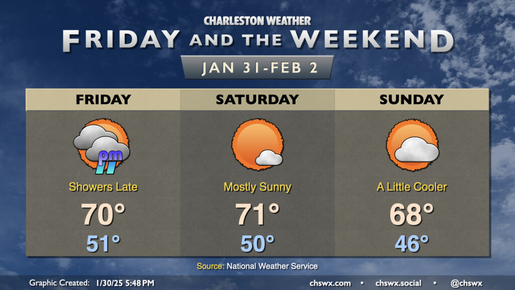
We stay well on the warm side of normal as we finally say goodbye to January and welcome February. Friday will be a mostly cloudy and breezy day ahead of a cold front. Despite the cloud cover, warm air pumping in from the south will drive highs back into the 70s in the afternoon. There will be a risk of showers primarily after sunset through the overnight across the metro area. If you have late Friday plans, be ready to possibly run into some rain. Amounts should generally be light as these showers should be booking it, and they should be gone before sunrise Saturday.
The front clears the area Saturday with some drier air moving in, though we should still see highs top out in the low 70s with much more sunshine. Sunday turns a little cooler as winds turn a little more onshore with high pressure wedging southward into the area. Still, expect highs in the upper 60s under partly cloudy skies — not too shabby, especially if we get caught in a classic Groundhog Day temporal loop. Enjoy!
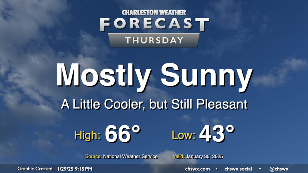
After the warmest day of 2025 so far, in which we reached 72° at the airport and 70° downtown, a dry cold front knocks our temperatures down a few degrees for Thursday, but it’ll still feel quite good outside. Expect mostly sunny skies to help low temperatures in the low-to-mid-40s warm to the mid-60s in the afternoon. An easterly wind at 10 MPH will keep things a touch on the breezy side, but otherwise, no concerns for Thursday.