Jared Smith founded @chswx on Twitter in 2008 as an experiment in disseminating weather data through social media. In the ensuing decade-and-a-half, @chswx has provided live coverage of tropical cyclones, tornadoes, severe weather, and even a couple bouts of winter weather to the good people of Charleston, SC.
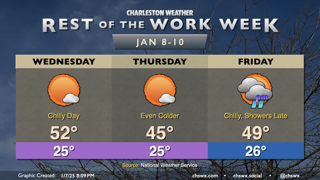
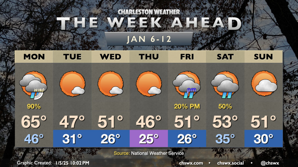
The chilly week continues as we get over the hump and down the stretch with high pressure in place for a couple more days ahead of a storm system that will affect the area Friday night into Saturday. You’ll want to make sure you have sensitive plants covered and your pets indoors the next few nights for sure with such cold temperatures expected!
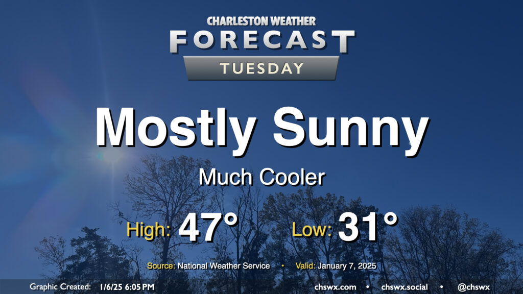
The weather takes a turn for the cold and stays there for the rest of the work week starting Tuesday in the wake of a front that passed through Monday evening. We’ll start Tuesday below freezing away from the coast, with lows in the low 30s expected. A bit of a breeze — though certainly not the gusty winds we saw on Monday — will keep wind chills in the low 20s Tuesday morning, so prepare accordingly for bus stops. Highs on Tuesday will struggle to the mid-to-upper 40s despite plenty of sunshine as cold and dry high pressure builds in.
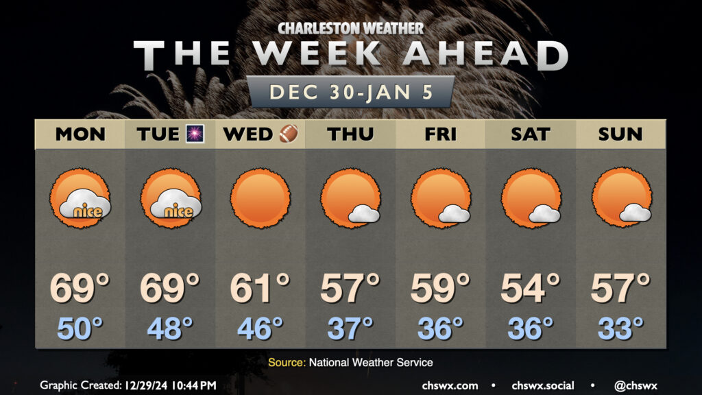
A chilly week ahead is bookended by two winter storm systems that will affect the area. Whether wintry precipitation gets involved remains to be seen; the probability of anything but cold rain taking place in the Charleston metro remains very low.
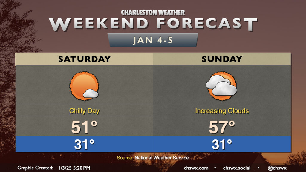
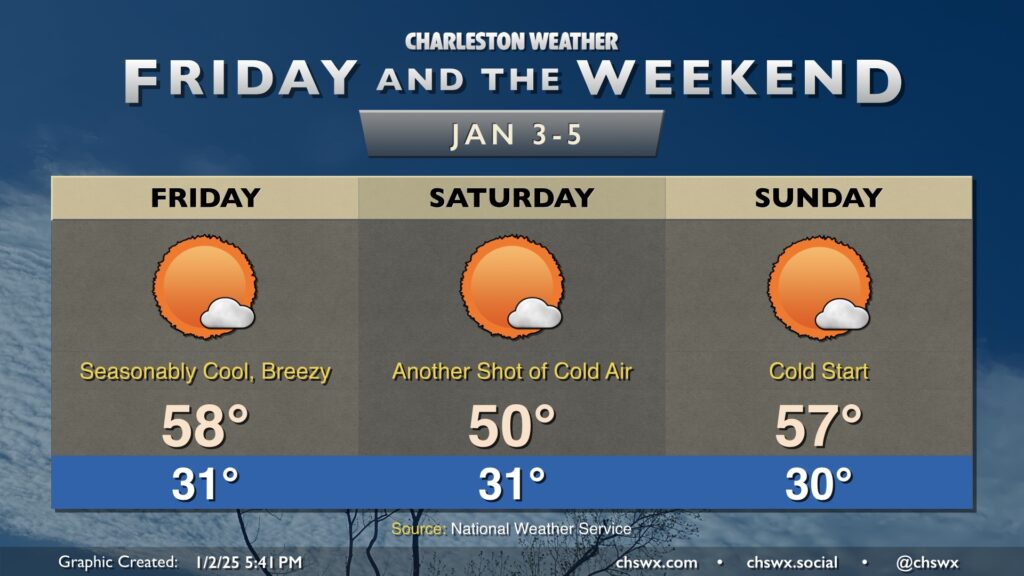
Expect largely quiet weather this weekend as high pressure generally maintains control over our weather. It’ll be chilly, though, even by January standards (especially Saturday). We start Saturday below freezing with lows around 30-31° in the metro, with wind chills dipping to the mid-20s around daybreak. As always this time of year, expect warmer low temperatures near the coast and even cooler temperatures in more rural, remote locations. High temperatures will only head to the low 50s in the afternoon despite plenty of sunshine. It’ll be pretty dry, too, with dewpoints mixing down to the upper teens in the height of the afternoon.
Sunday starts out on a similarly cold note, but we’ll start to see high pressure wane a little throughout the day ahead of the next storm system. Expect an uptick in cloud cover as Sunday goes on, but otherwise, winds turning a little more southerly will allow for temperatures to warm to the mid-to-upper 50s. Rain should hold off until after midnight, thankfully, so we’ll get the dry weekend intact.
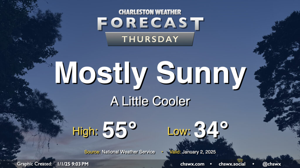
High pressure will be settling into the area overnight into Thursday, and this will drive a mostly sunny but seasonably cool day across the area. Expect lows in the mid-30s (with perhaps some freezing values in rural locations) to start Thursday, warming to just the mid-50s in the afternoon despite all the sunshine. Generally, temperatures will be running a few degrees below early January normals (normal high of 60°, normal low of 39°), but nothing terribly out of bounds.
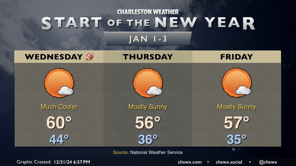
2025 gets off to a seasonably cool start in the wake of a cold front that will be coming through overnight tonight. Lows on Wednesday bottom out in the mid-40s, but ongoing cool advection will keep highs around 60° or so despite just about full sunshine during the day. Thursday runs a little cooler, starting in the mid-30s and warming to just the mid-50s in the afternoon, and Friday is essentially a carbon copy, with lows in the mid-30s once again yielding to highs in the mid-50s in the afternoon with plenty of sunshine. Overall, the start to the year is quiet, with the first rain chance of the year coming up on Monday.
Have a happy and safe New Year’s celebration. Here’s to you and yours in 2025!
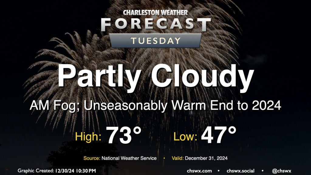
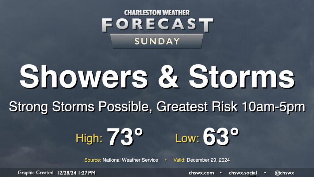
After a windy and wet cold front on Sunday that, thankfully, was devoid of any severe weather in the Lowcountry, we’ll finish 2024 on a warm but quiet note and ring in 2025 with more seasonable temperatures.
Sunday looks to be an active weather day as a cold front approaches the area. Expect at least scattered to numerous showers and thunderstorms to develop throughout the day, with a possible squall line moving by sometime in the early to mid-afternoon hours.