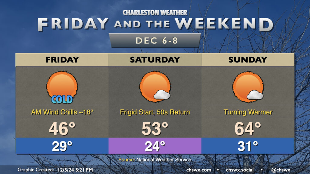
Friday & the weekend: Seasonable temperatures with a mix of sun and clouds
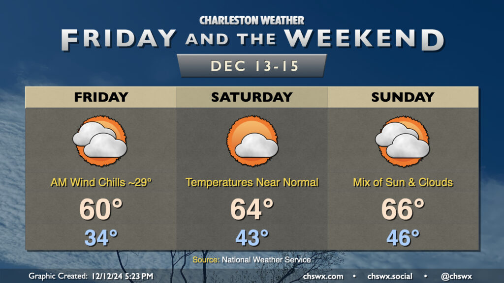
After a chilly start Friday, we start to see temperatures warm up more toward mid-December normals heading into the weekend.
Read more »After a chilly start Friday, we start to see temperatures warm up more toward mid-December normals heading into the weekend.
Read more »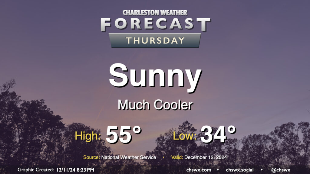
A cold front passed through earlier Wednesday will make Thursday a much cooler day despite plenty of sunshine. We’ll start the day in the mid-30s — with temperatures possibly dipping toward freezing in more rural areas — and warm to just the mid-50s in the afternoon despite all the sunshine. The wind won’t be whipping as much Thursday, with speeds generally around 5 MPH expected out of the north and northwest. Overall, it’ll be a seasonably cool day, with temperatures running several degrees below normal.
Read more »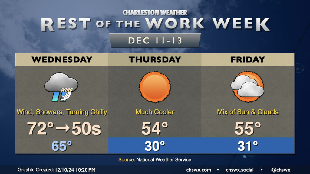
Wednesday will be a fairly unsettled day across the area as a cold front moves by, sending mid-morning temperatures in the 70s down to the 50s before sunset. Showers should be in the area by daybreak, with the greatest risk of showers and maybe even a thunderstorm or two generally mid-morning through early afternoon. A couple of those storms could be on the strong side with strong wind gusts the main concern, though the risk for any severe weather is fairly low. Even outside of thunderstorms, gusts 30-40 MPH will be possible, prompting a Wind Advisory for tidal Berkeley (Daniel Island, Wando, Cainhoy) and Charleston counties from 6am-1pm. Once the front is through, rain chances will end and temperatures will begin to fall like a rock. It won’t feel like it when you leave in the morning, but you’ll probably want a jacket handy as temperatures fall into the 50s by evening.
Read more »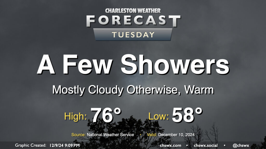
More cloud cover (with a few peeks of sun, especially early) is expected on Tuesday, but despite this, warm, humid air will continue to pump into the area ahead of a slow-moving cold front. This will make for a very mild day, with lows in the upper 50s warming to the mid-70s in the afternoon — some 10-12° above normal for December 10. We’ll also see the risk for some showers from time to time, but we’ll get rain-free time, too, especially midday.
Read more »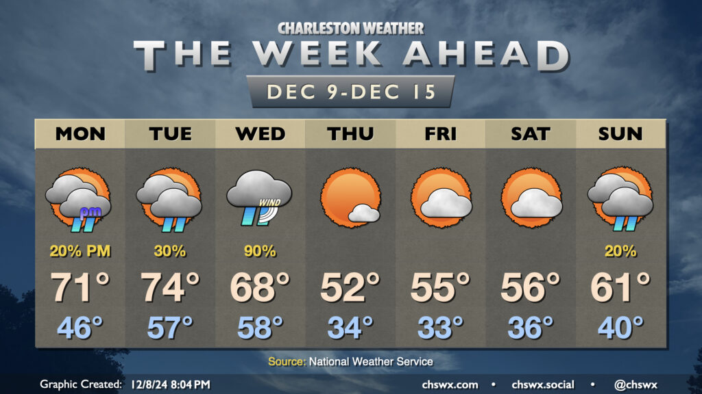
We get off to a warm start this week as temperatures return to the 70s for a few days (albeit with showers, especially Tuesday into Wednesday), followed by another cooldown that sends temperatures back below normal for the second half of the week, though not to the extent we saw last week.
Read more »
We are off to another frigid start on Saturday. Many spots in the metro will dip into the low 20s, with upper teens expected further inland. A Cold Weather Advisory is in effect for inland Berkeley and Dorchester counties, with the expected window of coldest air between 3-9am. Temperatures will moderate throughout the day, and we should get back above 50° once again, with highs topping out about in the low to mid-50s under sunny skies.
Temperatures will take another plunge toward freezing on Sunday morning, though we can expect lows to generally run some 10-12° above where they were on Saturday morning. This will mean that some spots inland will likely dip back into the low 30s once again, but much of the metro should stay just above freezing, especially the closer to the coast you are. We’ll see a few more clouds as high pressure starts to move offshore, and the resulting return flow will allow highs to peak in the mid-60s — much closer to normal for this point in December and some 20° warmer than we felt on Friday!
The warming trend continues for the first part of the week as the next storm system works into the area, with rain chances starting Tuesday and peaking Wednesday. The end of next week looks to close out below normal once more, though not to the advisory-level cold we’ve had recently.
Enjoy the weekend and don’t forget to bundle up!
We have a few more chilly days in store this week, especially on Friday, as another shot of cool air works its way through the area. (At least it won’t rain!)
Read more »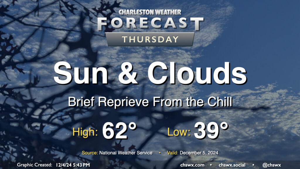
A warmer day is on tap Thursday as we sit between one Arctic-sourced high pressure system moving away and another approaching the area that’ll chill us right back out for Friday. We start the day in the upper 30s to around 40°, which will run much warmer than we ran on Wednesday morning after lows in the 20s for much of the area (and even some upper teens in northern Berkeley County!). Temperatures will top out in the low 60s in the afternoon as gusty southwest to westerly winds (perhaps approaching 30 MPH at times) ahead of the next front keep us a little warmer. We should see the front come through with little fanfare other than an uptick in cloud cover, especially in the first part of the day.
Read more »
We’ll add a little amplitude to the temperature rollercoaster as we get into the second half of the work week as one high pressure departs and another builds back in.
Read more »
A shot of cold air will drive temperatures back below freezing for Tuesday morning, with some upper 20s likely inland. The metro area should stay closer to the low 30s, but tomato, tomahto — it’s just gonna be cold. A decent northerly breeze will drive wind chills down into the mid-20s, too. Make sure you’ve got pets and plants in a safe and warm place overnight. Temperatures will struggle to the upper 40s at best in the afternoon despite plenty of sunshine, indicative of just how frigid of an airmass we’ve got to work with on Tuesday. Bundle up!
Read more »