Jared Smith founded @chswx on Twitter in 2008 as an experiment in disseminating weather data through social media. In the ensuing decade-and-a-half, @chswx has provided live coverage of tropical cyclones, tornadoes, severe weather, and even a couple bouts of winter weather to the good people of Charleston, SC.
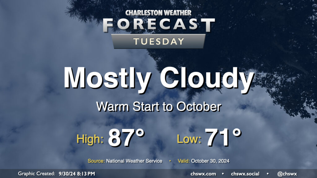
We’ll get October off to a warm but somewhat cloudy start before a cold front starts to regulate temperatures a bit more beginning Wednesday. We start the day rather mild for this time of year once again, with low 70s generally across the metro (and warmer toward the coast). Cloud cover does persist, but despite that, we’ll still warm into the upper 80s. Rain is not expected.
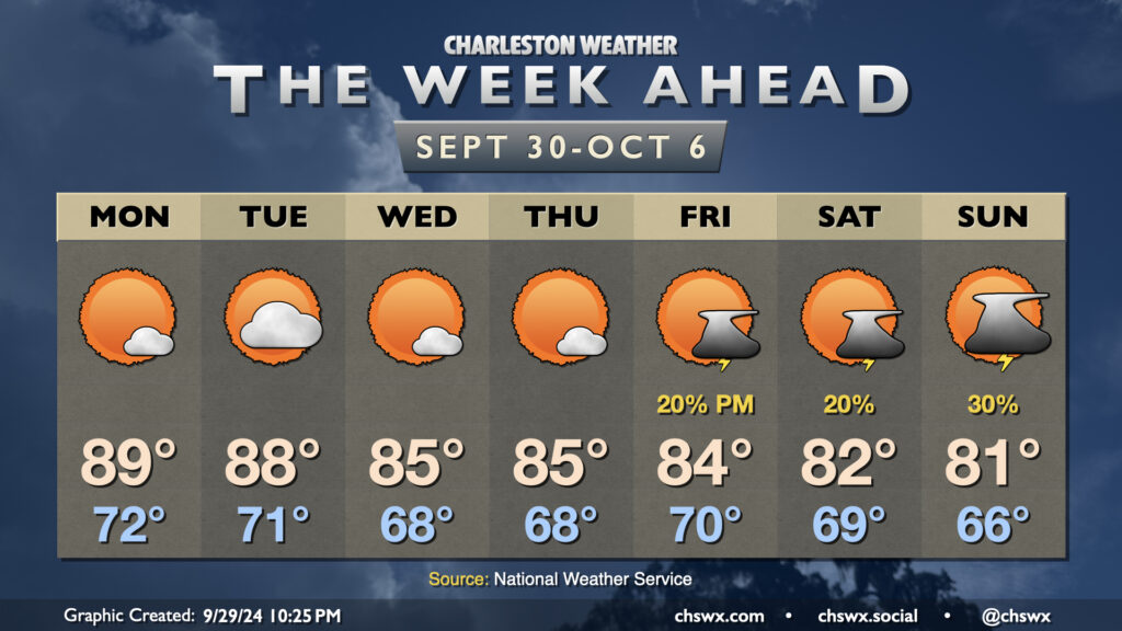
There’s not too terribly much to write home about in this week’s forecast so far, which is a fine departure from this point last week when we were looking at the genesis of what would become Hurricane Helene. We close September on a warm note, but a cooling trend begins to kick in by mid-week, with a few showers and thunderstorms — and much cooler conditions — possible by the weekend.
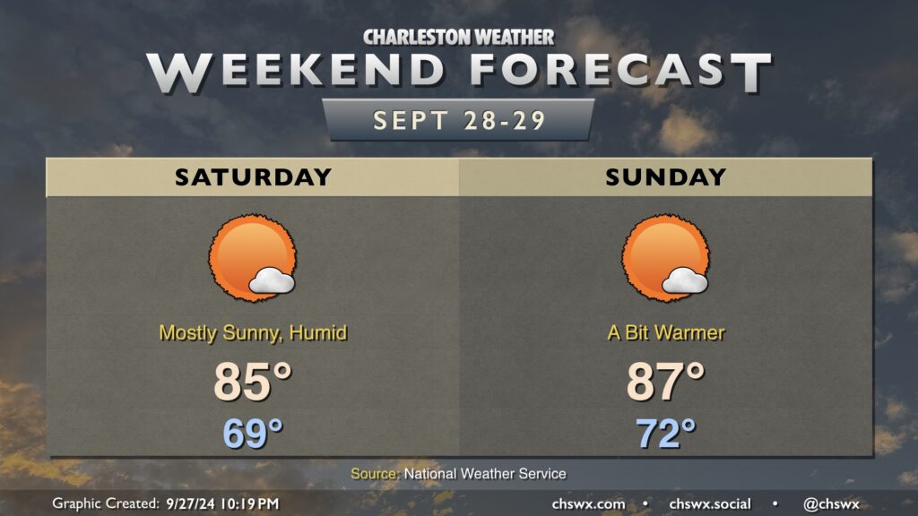
Quieter weather is in store for this weekend (though one could argue the bar is very low for that) in the wake of Helene. It’ll stay warm and muggy, though, as we head down the home stretch of September.
Saturday starts in the upper 60s to around 70°, warming to the mid-80s in the afternoon as a brief shot of cooler and drier air gets us off to a relatively cooler start. It’ll still feel closer to 90°, though, when factoring in dewpoints around 70-71°. The airmass modifies quickly, though, and by Sunday, we’ve got a late summer-ish day with lows in the low 70s warming to the upper 80s that’ll feel more like the mid-90s in the afternoon.
We have a few more days of the muggy airmass before another front sweeps through for the middle of next week, cooling us off pretty nicely as we head through the first week of October.
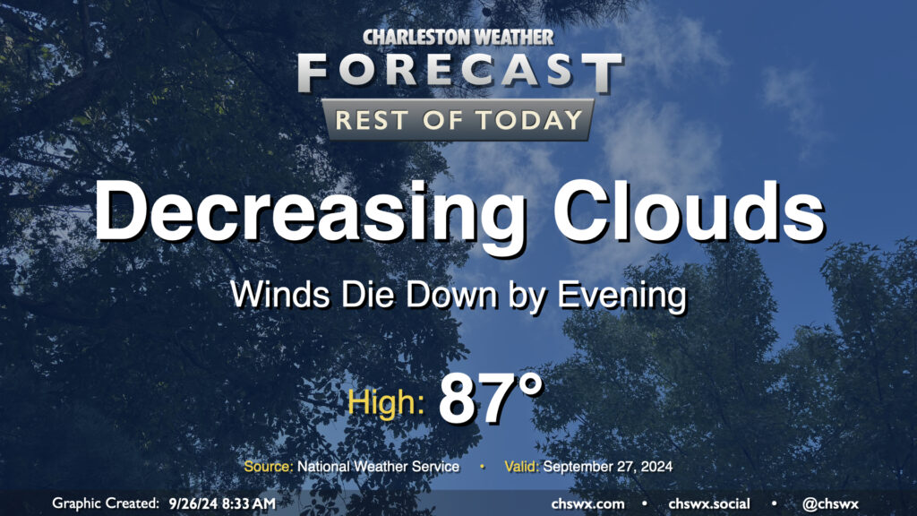
Improving weather is expected this afternoon into this evening as Helene continues to pull away from the area. Winds remain rather gusty — as of noon, a 48 MPH wind gust was reported at the airport — but will diminish as the afternoon wears on. It’ll stay warm and humid, with highs topping out in the low 80s as sun begins to peek through the cloud canopy. We’ll cool to around 70° overnight on our way back to the mid-to-upper 80s on Saturday.
Some housekeeping: The Flash Flood Warning that was in effect for the Charleston metro area, including downtown, has expired. The Tropical Storm Warning remains, but I expect that to be dropped by the 5PM advisory. And yes, the tornado threat has ended.
More on the weekend with this evening’s forecast post as the routine gets back to regular order. Thank you all again for your trust — it’s an honor to help guide y’all through these haranguing meteorological situations!
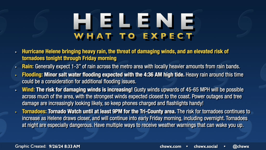
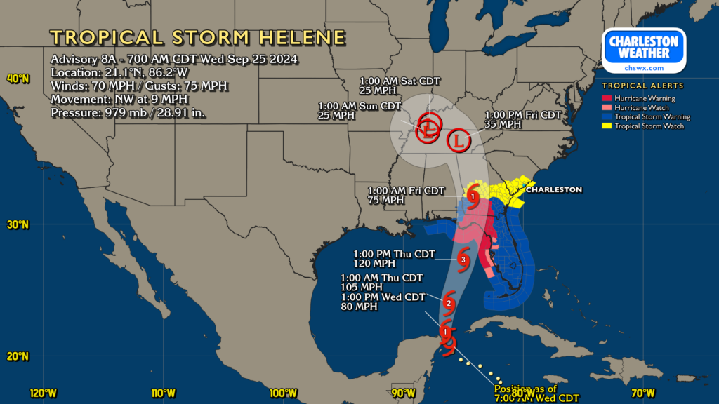
Category 4 Hurricane Helene continues to push toward a landfall in Florida this evening, intensifying rapidly as it does so. Here at home in the Lowcountry, we have been dealing with a fair bit of rain for much of the day, though the severe weather to this point has avoided the Tri-County. That may run out soon, though, as more rain bands develop and move ashore as we get into tonight and the overnight hours.
A potentially busy weather day awaits as Hurricane Helene strengthens again on approach to landfall late tonight on the Big Bend of Florida. A Tornado Watch is now in effect until at least 9PM, though I expect this to be extended overnight, as conditions continue to improve for the development of tornadoes. There has already been one tornado warning this morning in Beaufort County, likely with more to come. Tornadoes are the main concern with Helene, though heavy rain and gusty winds could still cause flooding and power outage issues.
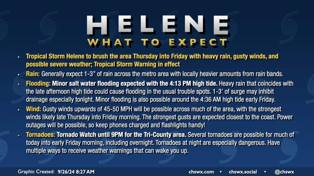
Hurricane Helene’s outer fringes will begin to affect the area on Thursday, with impacts peaking Thursday afternoon through Friday morning. Gusty winds, heavy rain, and a risk for tornadoes are the main concerns. A Tropical Storm Warning is in effect for the Lowcountry, including the entirety of the Charleston Tri-County area.
A Tropical Storm Watch is now in effect for the Lowcountry, including the Charleston Tri-County area, as Helene continues to organize and strengthen while it moves northward into the Gulf.
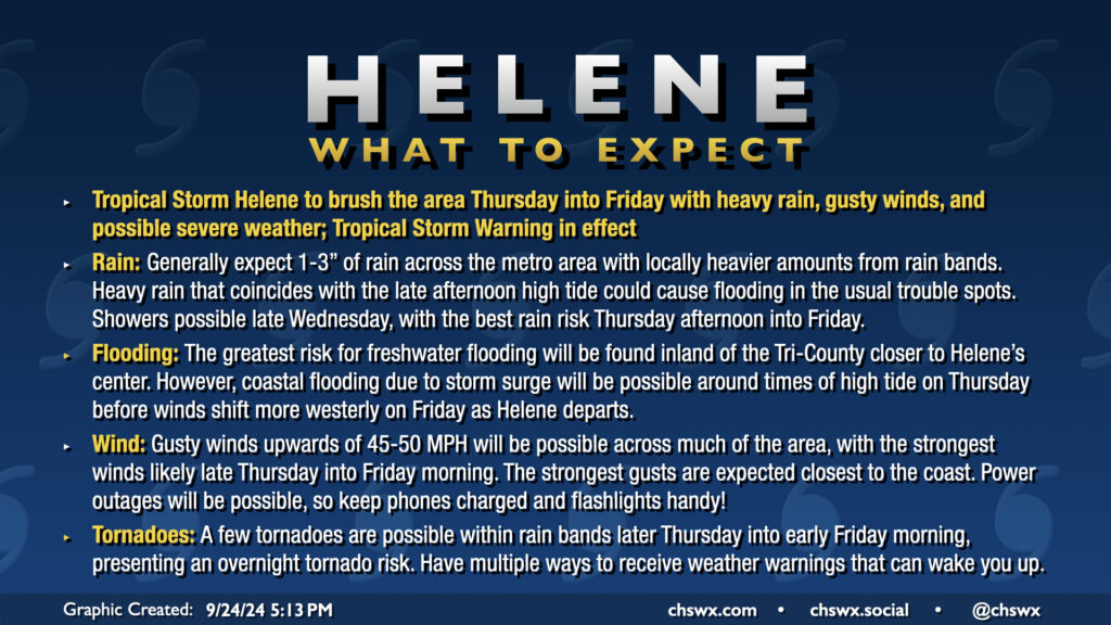
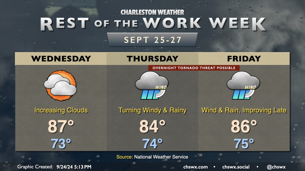
The rest of the work week will make you not want to hear the name “Helene” for a little while after it’s all over. We have one more day before wind and rain associated with the tropical storm arrive in the Lowcountry on Wednesday; it’ll be a warm and muggy day, but your last best opportunity to bring some loose things inside just to be safe. Temperatures start in the low-to-mid-70s, warming to the mid-to-upper 80s in the afternoon despite the increasing cloud cover. A few showers can’t be ruled out very late in the day, but the better chances for rain begin on Thursday.
On the current track, Helene will make landfall Thursday night in the Big Bend area of Florida as a major hurricane. It’ll be moving at a pretty decent forward speed, which should spread increasing showers and maybe thunderstorms into the area throughout the day Thursday. Helene’s impacts look to peak Thursday night into Friday morning, with gusty winds, heavy rain bands, and possibly a few tornadoes. Yes, we’ll need y’all to have your weather alerting devices in the on and alarming position Thursday night in case a tornado warning is issued. Some coastal flooding is also possible especially around high tide as onshore winds push some storm surge into the area, though the surge threat does not appear serious at this point.
Heavy rain and the tornado threat continue into Friday morning. Helene will be making quick work to the north and northwest, though, and we should see rain and wind gradually die down as the day goes on. Winds will start to take more of a westerly tack as Helene’s circulation moves away, and that should help blunt additional coastal flooding concerns on Friday. And by the weekend, we’re Helene-free.
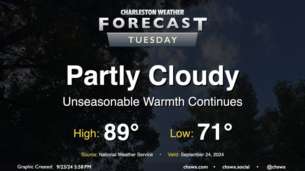
Quiet and unseasonably warm weather continues on Tuesday. Expect to start the day in the low 70s, warming to the upper 80s to around 90° in the afternoon. Dewpoints in the low 70s will yield heat indices in the mid-90s — not necessarily oppressive but certainly unpleasant considering where we are on the calendar. The ridge aloft will keep a lid on any shower activity, so no concerns there as we start to look ahead toward impacts from what is currently Potential Tropical Cyclone Nine later this week.