Jared Smith founded @chswx on Twitter in 2008 as an experiment in disseminating weather data through social media. In the ensuing decade-and-a-half, @chswx has provided live coverage of tropical cyclones, tornadoes, severe weather, and even a couple bouts of winter weather to the good people of Charleston, SC.
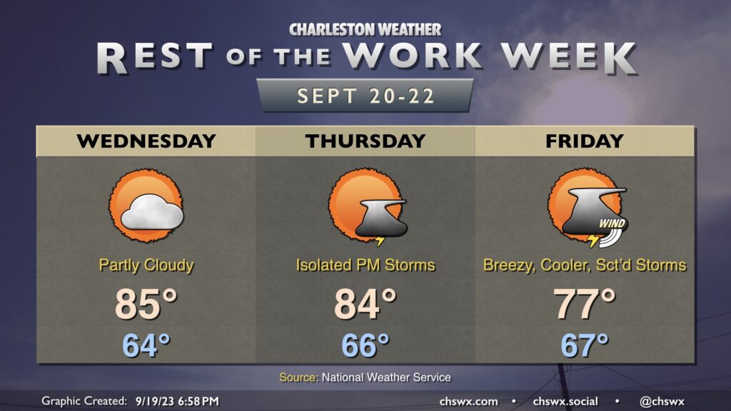
The rest of the work week will turn somewhat unsettled as a coastal low spins up later this week into the weekend. Wednesday still looks good, though, with seasonable warmth in the mid-80s under partly cloudy skies in the afternoon. We could see a couple isolated thunderstorms pop on Thursday as onshore flow becomes a little more pronounced as a coastal trough sharpens nearby. Temperatures will start in the mid-60s and top out in the mid-80s in the afternoon.
Friday is when we should start to see winds begin to kick up at the coast as the pressure gradient between low pressure developing offshore and high pressure over New England begins to tighten. The stronger onshore flow as well as a scattering of showers and a few thunderstorms will keep highs in the mid-to-upper 70s. Yes, there is still a low chance that this system could attain some tropical characteristics, but it’s not something I’d be overly concerned with. Could make for a less-than-ideal weekend at the beaches, though. Stay tuned to forecast updates as we get closer to the weekend.
We have another pretty day ahead for Tuesday (weather-wise, anyway). Temperatures start out quite nicely, with much of the metro starting in the low 60s. Some spots further inland could bottom out in the upper 50s, while places closer to the coast will generally feel warmer lows in the upper 60s. Temperatures head to the mid-80s in the afternoon. Dewpoints will mix down to the mid-50s except perhaps at the immediate coast, sending relative humidity values south of 40% once more. Overall, no complaints in the weather department.
After an incredibly soggy day across the Charleston metro, featuring another round of downtown flooding and rain totals exceeding 4″ in some spots, we get a couple days to dry out to start the work week. We start Monday in the mid-to-upper 60s and top out in the mid-80s as dewpoints fall into the low 60s throughout the day, which will make it an awfully nice day for an emotional support lunch outdoors as we head back to work. We keep the vibe going into Tuesday, with a somewhat cooler start thanks to the lower dewpoints in the area. A few more clouds are expected, but otherwise expect another nice day. Winds go northeasterly on Wednesday and could bring a few showers or storms into the area, but otherwise, much of us should stay rain-free.
Things get weird starting Thursday and heading into the weekend. Models are in good agreement that low pressure will spin up nearby in something resembling more of a nor’easter setup than anything else. However, if it stays over water (which is still plenty warm), there’s a chance it could try to acquire some tropical characteristics. Right now, the forecast is for some periods of rain and some gusty winds particularly near the beaches, and regardless of whether the storm is cold-core, warm-core, or hybrid, the impacts should be relatively straightforward. Obviously, we’ll keep an eye on this, but for now, not seeing anything extraordinary here. Stay tuned to forecast updates in the meantime.
After a fairly glorious day of weather Saturday, Sunday will make a 180° right back into more unsettled territory as high pressure moves offshore ahead of a cold front. A wave of low pressure will develop back in Georgia, helping to drag a warm front across the area in the morning. We’ll see an uptick in shower and thunderstorm activity possibly as soon as mid-morning, but the most likely time for rain will be in the afternoon hours through about sunset. Heavy rain will be possible, with the potential for rainfall in the 2-3″ range for some locations. Isolated flooding will be possible as a result. Additionally, the aforementioned surface low pressure looks to track inland of the area, and could enhance some low-level shear. If instability can develop — and that is a big if — a strong to severe storm or two will be possible, and there may even be a couple rotating cells. We’ll keep an eye on this, but the risk for severe storms generally remains low especially given the rain-cooled air. We start the day in the upper 60s, but highs only top out in the low 80s given the risk for widespread rain in the afternoon.
After this passes, it looks like we get off to a solid start to the work week (weather-wise, anyway), with mid-80s highs, comfortable low 60s dewpoints, and ample sunshine.
Well, if you’re going to do outside stuff this weekend, Saturday’s probably the day to do it. It’s going to be a gorgeous day — low humidity, plenty of sunshine, and comfortably warm temperatures in the mid-80s after starting out in the upper 50s to low 60s across the metro.
High pressure will slip offshore late Saturday, and dewpoints will climb back into the 70s for Sunday ahead of a cold front. Expect showers and thunderstorms to become somewhat numerous Sunday afternoon into the evening as the front approaches the area. We could see some enhanced rainfall, too, courtesy of a wave of low pressure moving along the front. Temperatures should stay in the low 80s with the expected showers and thunderstorms. Generally, expect .5-1″ of rain across the area, with locally heavier amounts. Severe weather is not expected.
We get a break in the humidity Friday and Saturday as cooler and drier high pressure builds in from the northwest. Temperatures get off to a nice start on Friday, and persistent northeasterly winds will keep highs capped in the mid-80s as cloud cover decreases. Dewpoints, meanwhile, will plummet into the mid-50s, and this will allow relative humidity values to drop below 40%, making for rather comfortable warmth.
Saturday is probably the best day of the set to get outside, as we start the day in the low 60s before heading back to the mid-80s in the afternoon under mostly sunny skies. Dewpoints will again mix out into the mid-50s during the day, and we’ll have another round of sub-40% humidity.
High pressure slips offshore overnight Saturday, and by Sunday dewpoints will be rebounding back into the mid-to-upper 60s. Another front will be approaching the area during the day, and this will be the impetus for showers and thunderstorms as we get later into Sunday and Sunday evening. Highs top out in the mid-80s. Overall, expect temperatures to remain at or a little below normal as we head into next week.
A cold front will slip offshore early Thursday morning, but we won’t quite be feeling it just yet as some showers and thunderstorms will still be possible as moisture lingers across the area during the day Thursday. Highs top out once again in the upper 80s before showers and a few storms fire. Instability isn’t great and severe weather is not expected, though some heavy rain will yet be possible at times. The best chance to see a shower or storm looks to be in the afternoon and early evening hours.
Shower and thunderstorm chances — as well as temperatures — peak on Wednesday ahead of a cold front approaching the area. We’ll start the day in the low 70s with highs heading into the upper 80s in the afternoon before thunderstorms erupt generally along the seabreeze. A few thunderstorms could produce some strong wind gusts, with heavy rain and frequent lightning the more widespread concerns. The front should stall out to our west for the balance of the day before making its move through the area overnight Wednesday.
The airmass change behind the front will be somewhat slow at first. We’ll certainly see slightly lower dewpoints Thursday with air temperatures topping out a few degrees cooler as well, generally in the mid-80s. However, there should be enough low-level moisture to allow for a few popup showers and storms in the afternoon, so be ready for the potential to dodge a storm or two.
The airmass change picks up steam later Thursday into Friday, which looks positively brilliant. Expect lows in the mid-60s Friday to be followed by highs in the low 80s in the afternoon under nearly unfettered sunshine. Dewpoints will fall into the low-to-mid-50s during the day, providing a comfortably warm feel to the air. We’ll keep this going into the weekend, too, with lows bottoming out near 60° on Saturday. (Might even record a few upper 50s in some spots!) Fall is indeed coming, but these transitional seasons can be a little frustrating at times as the weather see-saws back and forth. (Hence “transitional season.”
Tuesday’s forecast will once again feature a seasonably warm and humid airmass that’ll give rise to some showers and thunderstorms in the afternoon, generally along and ahead of the seabreeze. We start the day in the low-to-mid-70s. Some fog may be around as we start the day, so be ready for possible visibility reductions particularly as you get further inland. Highs top out around 90° in the afternoon before a few storms fire, which will cool things off for some of us. A couple strong storms are possible, but don’t expect a widespread severe weather issue.
We will get off to a warm start for the first part of the work week, but a front will bring another taste of fall for the second half into the weekend.