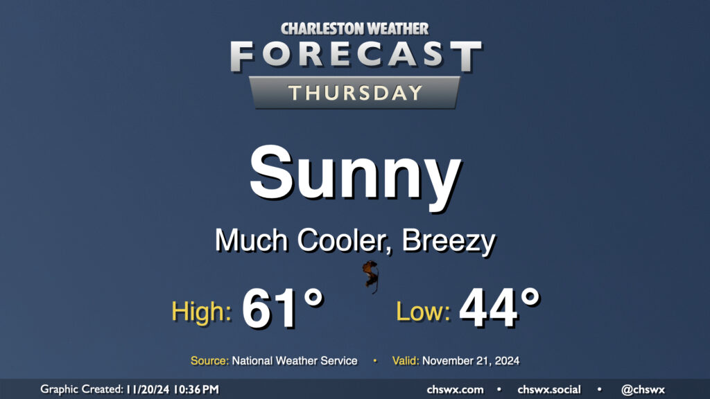
Thursday will kick off a stretch of below-normal temperatures that will continue into the first part of the weekend before we turn a little warmer for Sunday. We start Thursday in the mid-40s, but as cooler and drier air rushes into the area, producing some gusty winds at times, high temperatures will be limited to the low 60s at best despite full sunshine. This is closer to January normals than November normals — you’ll likely want to opt for some longer sleeves as a result, at least during the morning.
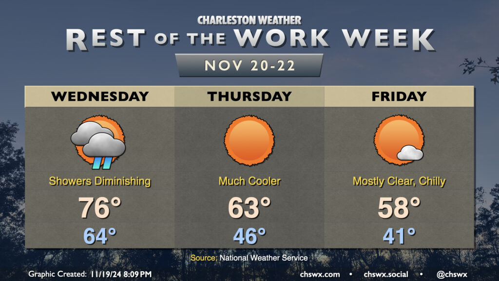
Showers will move into the area overnight and persist into a good chunk of Wednesday as a cold front moves by. We start Wednesday in the mid-60s, warming to the mid-70s in the afternoon. Showers should scour out by early evening, and from there, cooler and drier air will begin to work into the area. The airmass change will be very noticeable this go-around; we’ll start Thursday in the mid-40s, warming to the low-to-mid-60s in the afternoon at best. Friday will be even cooler, with lows in the low 40s warming to just the upper 50s in the afternoon despite full sunshine, roughly 10° below the normal temperature for November 22 and more reminiscent of normal highs for early January!
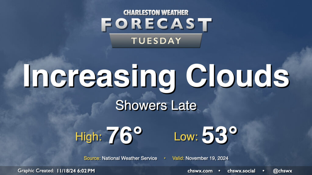
We’ve got another unseasonably warm day ahead Tuesday ahead of a front that will sweep through on Wednesday. Ahead of that front, we’ll see an increase in cloud cover, and eventually some shower activity later in the afternoon into the evening and overnight. Temperatures Tuesday start in the low to mid-50s, warming to the mid-70s in the afternoon. Southwesterly winds will keep the tides at bay, thankfully, and we should fall short of the coastal flooding threshold with the mid-morning high tide, with no coastal flooding expected for the next few days at least.
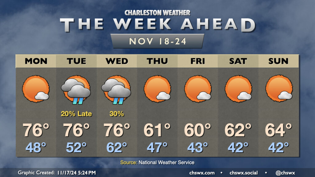
The week ahead gets off to a warm start, but some seasonably cool weather featuring temperatures a few clicks below normal sets in for the second half of the week.
Monday starts with temperatures in the upper 40s. As high pressure begins to shift offshore, we’ll start to see temperatures warm back to the mid-70s in the afternoon under mostly sunny skies. We’ll have one more round of coastal flooding in the morning, but it will not be nearly as severe as what we’ve seen the past few mornings as water levels should only peak around 7.2′ with the 9:31am high tide. Still, expect a few road closures in the more vulnerable trouble spots downtown for a few hours during the commute. From there, winds go more unfavorable and the astronomical impacts from the recent full moon continue to lessen.
The only period of unsettled weather looks to take place later Tuesday through Wednesday as a front comes through (the impetus for our cooldown beginning Thursday). Much of Tuesday should get in rain-free, but will be well on the warmer side of normal with lows in the low 50s yielding to highs in the mid-70s in the afternoon. Shower chances increase around and after sunset, and hang around through midday Wednesday. We’ll see cloud cover diminish as Wednesday goes on, but lagging cooler air will let temperatures back to the mid-70s for one more afternoon after an abnormally mild start in the low 60s.
Cool air begins to kick in overnight Wednesday, and we’ll start Thursday in the upper 40s. Highs on Thursday, though, will struggle above 60° despite considerable sunshine. We’ll repeat this performance on Friday, with an even cooler start in the low 40s. A slow warming trend begins over the weekend, but expect temperatures to remain below normal with highs in the low to mid-60s and lows in the low 40s each day with plenty of sunshine throughout.