Cool high pressure will be in control this weekend, and we will get a taste of more seasonable conditions for mid-November than we’ve had thus far this month.
First, though, there is the potential for major coastal flooding for the second time in three days with Saturday morning’s high tide, which is predicted around 7:46am. Water levels in Charleston Harbor are projected to peak between 8.1-8.3′ MLLW with this tide, and this will cause numerous road closures throughout downtown Charleston, as well as flooding issues on Isle of Palms, Mt. Pleasant, and perhaps even parts of James Island. Be vigilant and be ready to reroute in case you encounter a flooded road. A Coastal Flood Watch is in effect between 6-10am, and if trends continue, expect this to be upgraded to a Coastal Flood Warning. Also, if the predicted forecast height of 8.2′ comes to pass, it’d be a top-25 tide on record at Charleston Harbor.
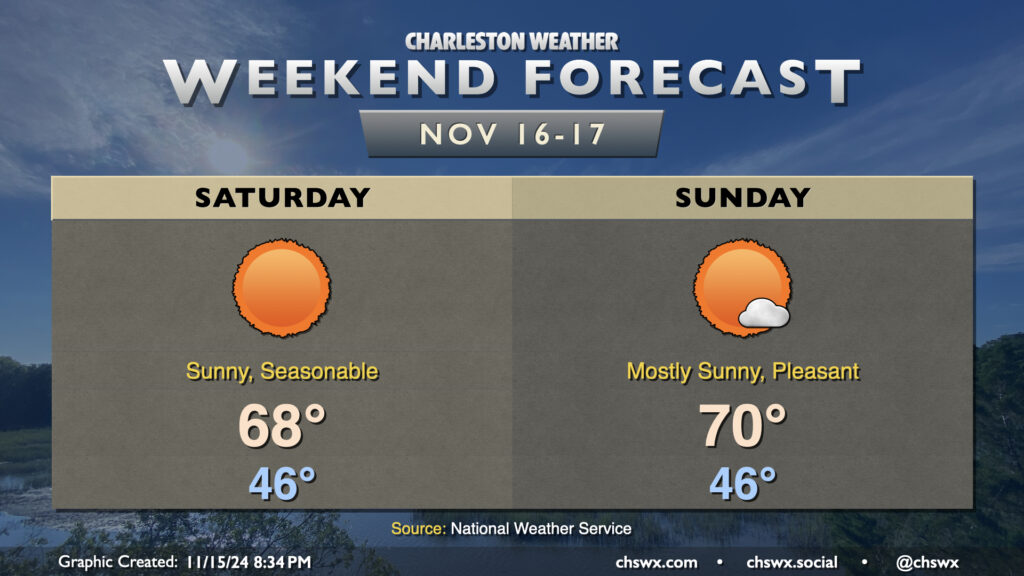
Water levels should diminish by mid-morning, and from there, a fairly nice Saturday commences. Expect quite a bit of sunshine, with temperatures warming from the mid-40s in the morning to the upper 60s in the afternoon, just about right on target for normal for this point in the year. Sunday should turn a touch warmer, but a high of 70° is just a teeny bit warmer than normal, so that seasonable feel will continue. Unfortunately, another round of moderate to major coastal flooding is possible with Sunday morning’s high tide, though it should not be as severe as Saturday’s.
From there, a warming trend commences for the first half of the week before a mid-week front. The second half of next week looks much cooler than normal, with highs possibly not making it out of the 50s next Thursday! But let’s enjoy the weekend first.
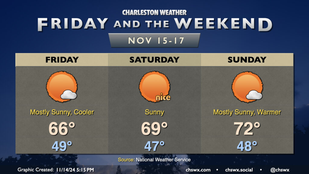
Showers scour out overnight Thursday, and by Friday morning, clouds will be diminishing as cooler and drier air works into the area. We’ll start the day in the upper 40s to around 50°, while the continued influx of cooler air will keep highs pinned to the mid-60s despite increasingly full sunshine. The only fly in the ointment will be the risk for minor to moderate coastal flooding around high tide, which should peak just before 7am. Water levels between 7.3-7.5′ are forecast, which will close some roads, though not as extensively as we saw Thursday morning.
Seasonable and quiet conditions continue for the weekend. Saturday should be a particularly nice day, with lows in the mid-40s yielding to highs in the upper 60s to around 70° in the afternoon, while temperatures turn a little warmer for Sunday as highs get to the low 70s after another upper 40s start. Sunshine will be very prevalent throughout the weekend, and I hope you get a chance to take advantage of weather that feels much more appropriate for mid-November.
Coastal flooding concerns will continue into the weekend, though, with major flooding expected with Saturday morning’s high tide as water levels are expected to peak around 8-8.2′ with the 7:46am high tide. Expect another round of numerous road closures in downtown Charleston on Saturday morning. Moderate to potentially major flooding can’t be ruled out for Sunday morning, either, as water levels once again approach 8′. Keep an ear out for Coastal Flood Watches, Warnings, and Advisories from the National Weather Service as your signal that travel could turn difficult.
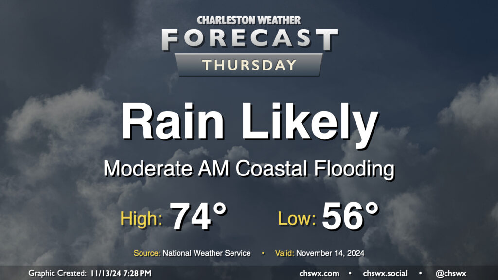
Thursday figures to be a somewhat wet day at times across the Lowcountry, starting with salt water flooding downtown and ending up with showers across much of the area by evening.
First, the salt water flooding: Water levels around 7.9′ MLLW are expected with the 6:07am high tide Thursday. This will produce fairly widespread coastal flooding in downtown Charleston, and should also affect Long Point Road and parking areas around Shem Creek in Mt. Pleasant. Expect numerous road closures early on in the commute, with improving conditions heading into 8-9am. Be alert to detours around the aforementioned road closures, and never cross through floodwaters even if a road is closed — remember, this is all going to be salt water and that is incredibly not good for your car’s undercarriage!
The risk for showers should, thankfully, miss the worst of the salt water flooding. It will begin to kick up around mid-morning to midday, with the best chance of showers on Thursday afternoon into the early evening hours. Rainfall amounts should generally stay under a half-inch in most spots, but locally higher amounts are possible where heavier showers develop. Temperatures start in the mid-50s, topping out in the mid-70s early in the afternoon.
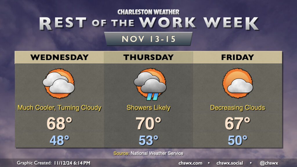
Cooler and drier air will push in overnight as high pressure wedges into the area from the north. This will make for a much cooler day on Wednesday than we’ve had in quite some time, with lows in the upper 40s in many spots away from the coast expected in the morning. High temperatures should only peak in the upper 60s as cooler air moves in. Increasing cloud cover as the day will also assist in keeping temperatures a little lower, too.
High pressure will break down Thursday as a cold front approaches, driving up the risk for showers particularly from midday into early evening. We’ll start the day in the low 50s, warming to around 70° in the afternoon. Rain should generally be on the light side, though some pockets of heavier rain can’t be totally ruled out, either.
The front clears the area for Friday, and cloud cover scours out during the day as a result. Temperatures, though, will once again struggle to the mid-to-upper 60s as cool air behind the front continues to push in. This sets the stage for a seasonably nice weekend, though, with lots of sunshine expected. Expect highs in the upper 60s Saturday, with low 70s returning for Sunday, right around where we should be at the midpoint of November.
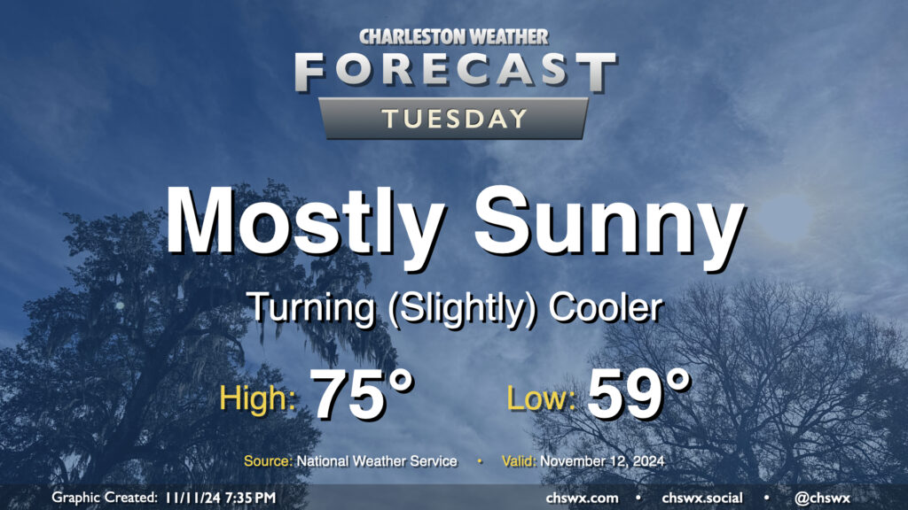
A front swinging through tonight will help start a cooldown across the area that will bring temperatures more in line with where they should be for this point in the year. Lows on Tuesday start in the upper 50s to around 60°, with highs only heading to about the mid-70s despite mostly sunny skies. Drier air will be moving in throughout the day, especially as winds start to go around to the northeast, and it should overall feel pretty nice especially given the recent swampiness that’s characterized November thus far.