A complex forecast lies ahead this weekend as we monitor for the potential for low pressure to spin up off the coast, which has a shot at potentially becoming tropical as it approaches the coast early next week.
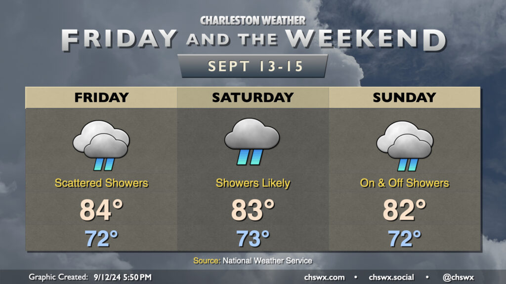
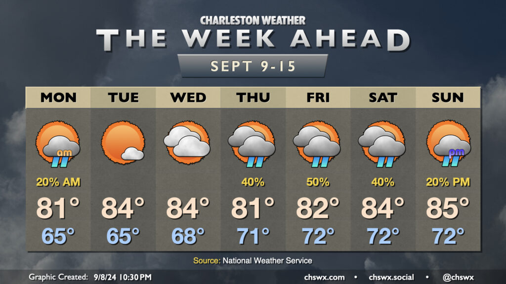
Showers will make a return to the forecast for Friday and the weekend as the dry air that’s been hanging on continues to erode. Models have been trending a bit drier for Friday, but scattered showers still appear to be a decent bet as lift improves atop the wedge of high pressure that remains in place, though it does look like the heaviest rain remains closer to the stationary front to our southwest. Temperatures start in the low 70s, warming to the mid-80s in the afternoon under predominantly cloudy skies, though some peeks of sun are possible from time to time.
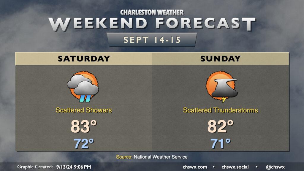
The weekend forecast turns a little lower-confidence as we watch for the potential for low pressure to spin up offshore on Sunday. Saturday, meanwhile, continues to look showery at times with the risk for a few rumbles of thunder as well as energy aloft interacts with a developing coastal trough. Temperatures generally run in the low 70s to start with highs in the low-to-mid-80s once again in the afternoon.
Sunday’s forecast could turn a bit on if and where low pressure spins up. For now, expect essentially a repeat of Saturday, with temperatures running in the low 70s to start the day, heading into the low 80s in the afternoon. A faster and more southerly low pressure system could increase the risk of heavy rain in the area later Sunday. Guidance is still a little split on where and when low pressure ultimately develops, but the general expectation is that it spins up offshore by Monday, trekking northwestward and reaching shore by Tuesday, with heavier rain on the northern side of the low. It’s hard to know right now if it will shed its fronts and turn tropical, but the Hurricane Center pegs the area of concern at a 30% chance (low risk) to develop over the next seven days. We’ll keep an eye on this, and you probably should as well, though it still doesn’t look like anything that develops will have much of a chance to get particularly strong.
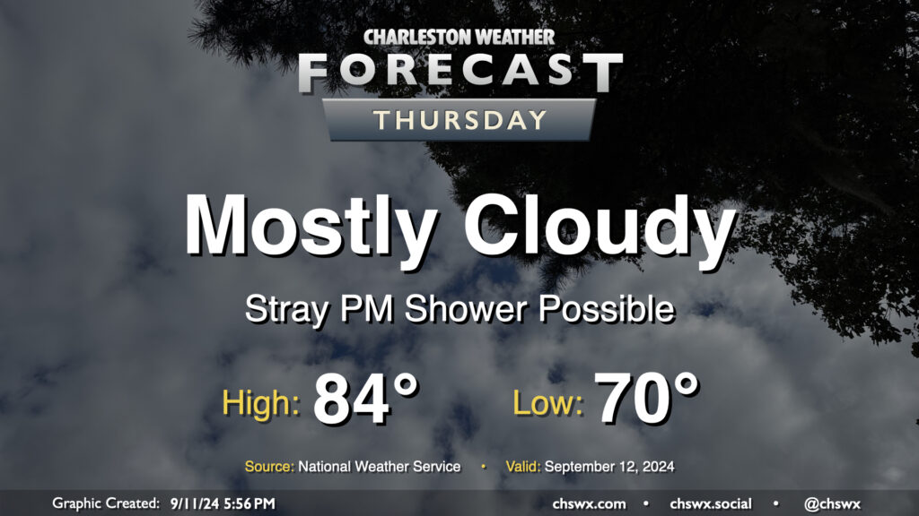
Cloud cover will continue on Thursday as moisture from Hurricane Francine, which has made landfall in Louisiana as a Category 2 storm with maximum winds of 100 MPH, continues to push northward across the Southeast and into the Lowcountry. High pressure will try to hang on across the East Coast, though Francine will continue to dislodge it north and east. Moisture moving atop high pressure will create plenty of clouds and may be enough to get a few showers going in the afternoon as well, though many of us should stay dry for one more day. We start Thursday around 70°, warming to the mid-80s in the afternoon despite the cloud cover.
After a beautiful Tuesday featuring plenty of sun and comfortably warm temperatures, cloud cover returns to the area as moisture from Hurricane Francine lifts northward across the area. While Francine won’t have direct impacts in the Lowcountry, its northward advance into the Mississippi River valley will shove high pressure offshore, allowing the stationary front that has been draped to our south to start to retreat northward a bit. Upglide across the frontal surface and high pressure will help produce showers and maybe a few thunderstorms as well.
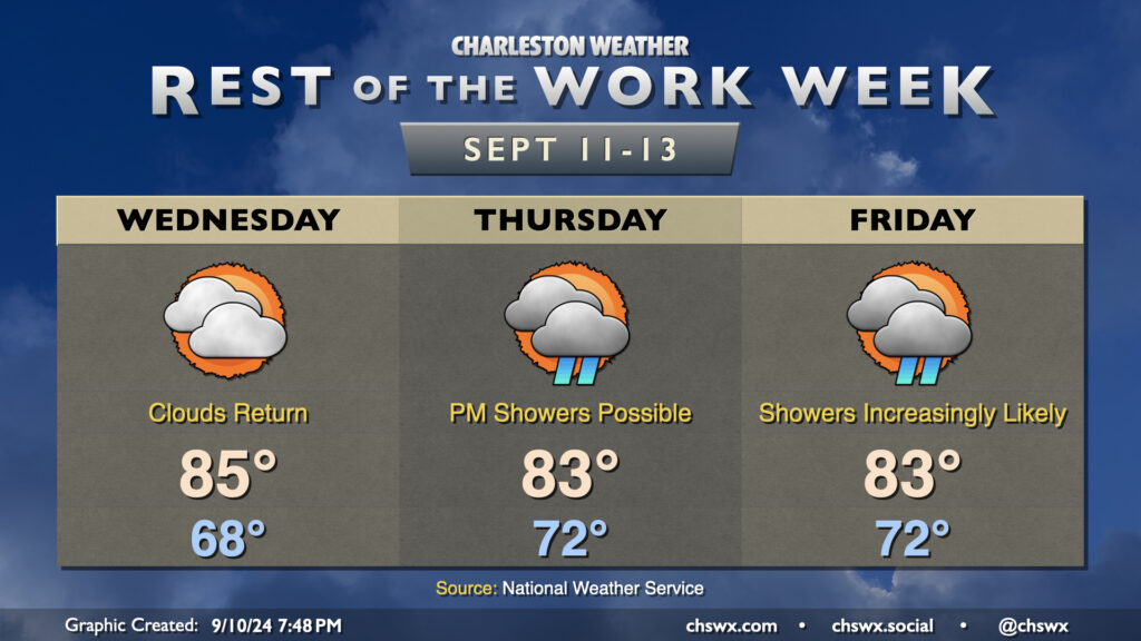
Wednesday looks to be rain-free with merely an uptick in cloud cover and dewpoints. We’ll start the day much warmer than we started Tuesday, with lows generally in the upper 60s to around 70°. Temperatures warm to the mid-80s in the afternoon despite the increasing cloud cover.
Much of the metro should get Thursday in rain-free as dry high pressure continues to hang tough at the surface, but we’ll start to see that erode with time, introducing some shower chances to the forecast starting Thursday afternoon. Cloud cover and persistent northeasterly winds will cap highs to the low to mid-80s after starting in the low 70s. Moisture more fully overtakes the area by Friday, and this leads to increasingly numerous showers and maybe some thunderstorms across the area as we get through the day, with rain chances peaking in the afternoon and evening hours. Once again, highs will be limited to the low to mid-80s with the cloud cover and expected rain.
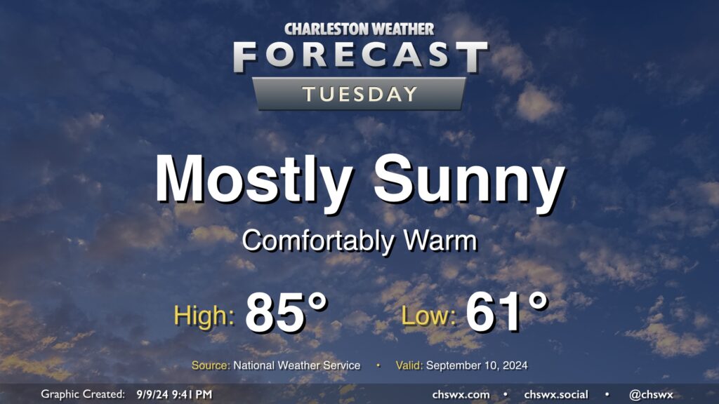
Tuesday looks like a rather nice day in our part of the world with mostly sunny skies, a seasonably cool start in the low 60s, and highs in the mid-80s with relatively low humidity as high pressure’s influence on the area peaks before moisture returns starting Wednesday. I hope you can take advantage! Unsettled weather will return to the area by Thursday.
Below-normal temperatures will continue this week as we remain under in the influence of high pressure anchored to the northeast, with showers taking a break for a few days before returning to the forecast for the weekend.
A few lingering showers will be possible Monday morning with a stationary front nearby, though high pressure will continue to nudge that front further and further south, clearing us out for a couple nice days. Mostly cloudy skies keep highs capped to the low 80s on Monday after a mid-60s start, but we should see gradual reduction in cloud cover throughout the day. Tuesday looks to be rather nice, with lows in the mid-60s yielding to highs in the mid-80s under partly cloudy to mostly sunny skies. We’ll start to see the front to our south buckle a little more as low pressure — which is forecast to become Hurricane Francine — moves toward the Louisiana Gulf Coast during the middle of the week. This will net us an uptick in cloud cover and dewpoints for Wednesday, but we’ll get one more rain-free day in.
The high pressure center to our northeast that’ll give us a relatively quiet start to the week will be nudged eastward, which will allow the persistent stationary front to retreat a bit northward. This will bring an uptick in shower chances beginning Thursday and lasting into at least Saturday. It won’t rain all the time, but you’ll want to consider indoor plans as a backup to any outdoor plans. High temperatures will head down a bit with the uptick in cloud cover and showers, with highs in the low 80s expected Thursday and Friday before winds get a little more due-east, bringing some warmer temperatures back to the area for the weekend. Still, though, we stay below mid-September norms, generally running in the mid-80s Saturday and Sunday.