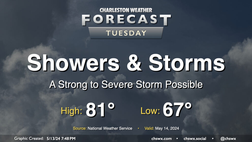
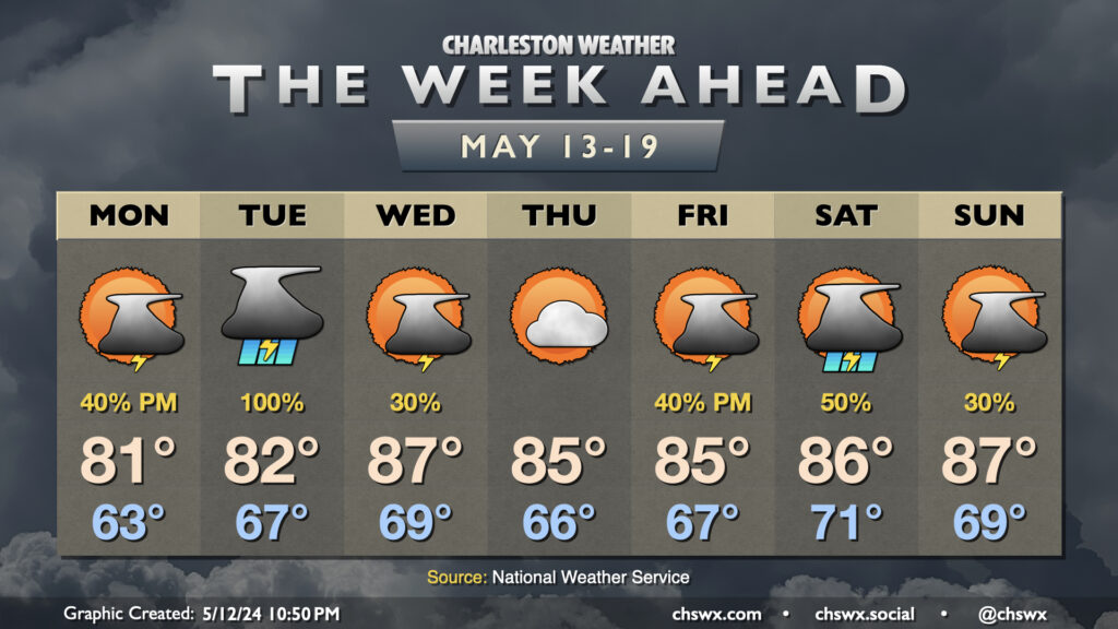
Tuesday figures to be a fairly active weather day with a couple rounds of storms expected. The first one will be ongoing as we wake up and commute; periods of heavy rain will be possible within thunderstorms, so be ready for delays in the morning. One other twist will be in the form of a warm front that will lift north across the area as we get into mid-morning; this could enhance low-level shear enough where the environment might support a brief tornado (though this risk is fairly low all things considered). The first round of showers and thunderstorms should get offshore roughly around midday, and many of us will catch a break from the rain early Tuesday afternoon. Heading into mid-to-late afternoon, expect additional scattered showers and thunderstorms to fire across the area. There will be a damaging wind risk within the strongest storms, so you’ll want to keep an ear out for possible weather warnings. Storms will be possible well into the evening before chances head back down around midnight or so.
Temperatures Tuesday start on the warm and muggy side in the mid-to-upper 60s. Expect highs to top out in the low 80s given the expected showers, thunderstorms, and overall cloud cover.
I hope everyone got to enjoy this fine Mother’s Day weekend, because we are getting back to storms for a good chunk of the upcoming week. We start Monday on a dry note, but shower and storm chances will increase as a disturbance moves across the Gulf Coast states toward the East Coast. We start Monday in the low 60s, warming to the low 80s in the afternoon with clouds on the increase ahead of shower and thunderstorm chances later in the day.
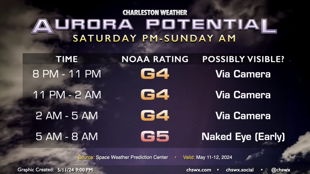
The latest forecast update from the Space Weather Prediction Center calls for G4-G5 geomagnetic storming overnight, with the peak of the activity expected right around sunrise (alas) as another round of G5 conditions is expected.
As of 9PM, the geomagnetic storm index is, well…G-Zero. It is expected to ramp back up, but weaker than last night when the storm remained at G5 levels for much of the evening. This will mean that it’ll be a later night for aurora-watchers here in the Lowcountry, and that y’all will indeed have your best chance at seeing something if you are in a dark place and using a camera. We just cannot expect that we will see aurora to the degree we saw it last night, and it may not even be close. And by the time the expected G5 conditions kick in, we’ll be getting into dawn, and that will end the chance for us to see aurora here. Sunday evening’s forecast right now doesn’t look too favorable here with generally G3 conditions at best as the storm dies down, so if we’re going to see any additional aurora, it’s going to have to be tonight.
If you are going to stay out a while tonight, pack a hoodie — lows dip into the upper 50s under clear skies. Good luck, aurora-hunters!
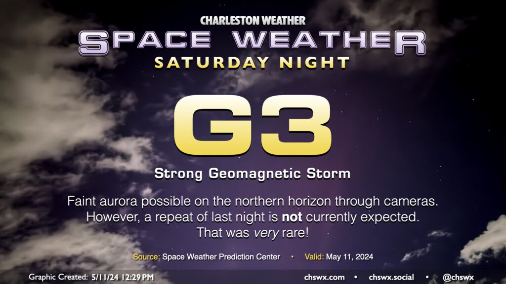
Well, last night was something else — you just don’t see aurora this far south every day, and the degree to which we saw it was so incredibly rare. The fact that many of you were able to see it with the naked eye speaks well to the strength of the storm: a G5 event, according to the Space Weather Prediction Center, which hasn’t happened since October of 2003.
The geomagnetic storm continues over the weekend. However, it probably peaked last night. G3 conditions are forecast for tonight, which would preclude most of us from seeing aurora unless we were in a dark place with a good view of the northern horizon using a camera with a wide-open aperture. Clouds will not be an issue tonight as fair-weather cumulus will diminish with the loss of daytime heating. If anything, you might want a hoodie if you’re going to go looking! But once again, I want to set expectations very carefully: we just cannot expect a repeat of last night’s display tonight. G5 geomagnetic storms are incredibly rare, and that’s the strength we need for the kind of display we saw yesterday here in the Lowcountry. (It’s not too late to head to the NC mountains, though!)