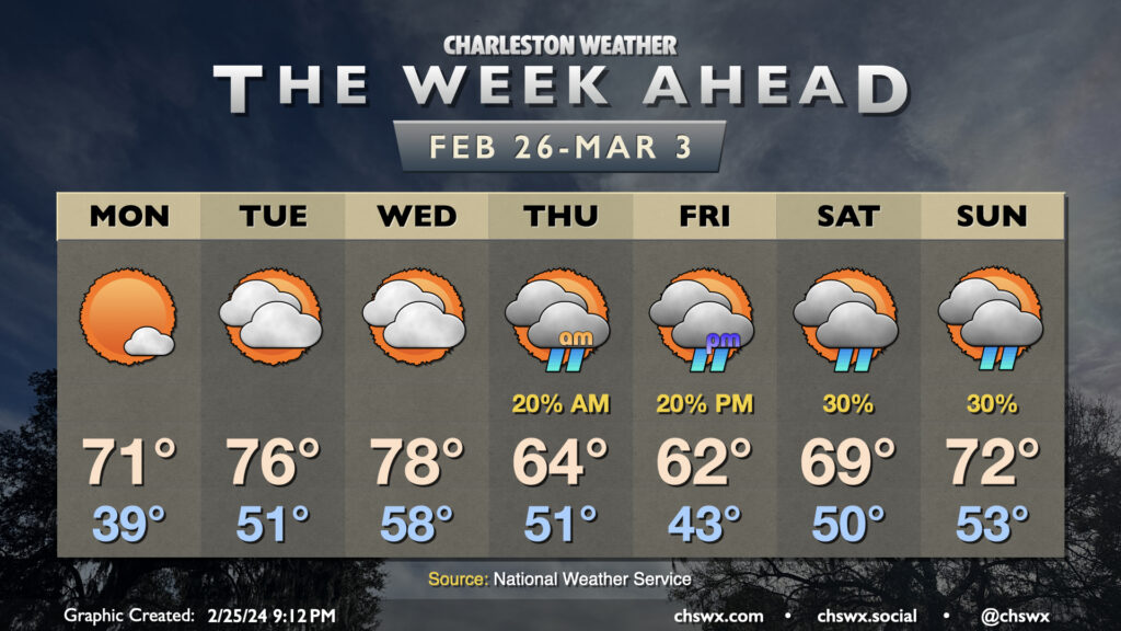
Sunday’s chill yields to a much warmer few days to start the new week and close out February. After a chilly start in the upper 30s, temperatures on Monday will rise into the low 70s, several degrees warmer than we reached on Sunday, thanks to plenty of sunshine and winds starting to go southerly as surface high pressure moves offshore. The warming trend continues for Tuesday and Wednesday, with lows in the low 50s on Tuesday yielding to highs in the mid-70s in the afternoon. Wednesday will start well above normal — think upper 50s — before temperatures make a run at 80° in the afternoon despite a mix of sun and clouds.
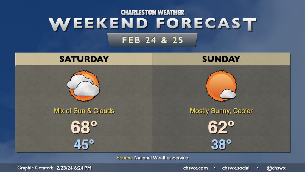
This weekend’s weather is generally looking quiet, with a fair bit of sunshine and temperatures generally a few degrees within normal. Saturday will run on the warm side of normal behind Friday night’s cold front, with lows bottoming out in the mid-40s before warming to near 70° in the afternoon. Another cold front will come through later Saturday accompanied by an uptick in cloud cover for most of us. A shower or two will be possible near the Santee, but other than that, the vast majority of us stay rain-free.
This front brings cooler-than-normal temperatures for Sunday, though not horrendously so: lows bottom out in the upper 30s with a slight north wind taking wind chills to the mid-30s. Sunshine looks to be more in abundance on Sunday than Saturday, and this will help temperatures head to the low-to-mid-60s in the afternoon. Temperatures rebound quickly into the 70s on Monday, with warming continuing through at least midweek as we put the finishing touches on another relatively warm climatological winter.
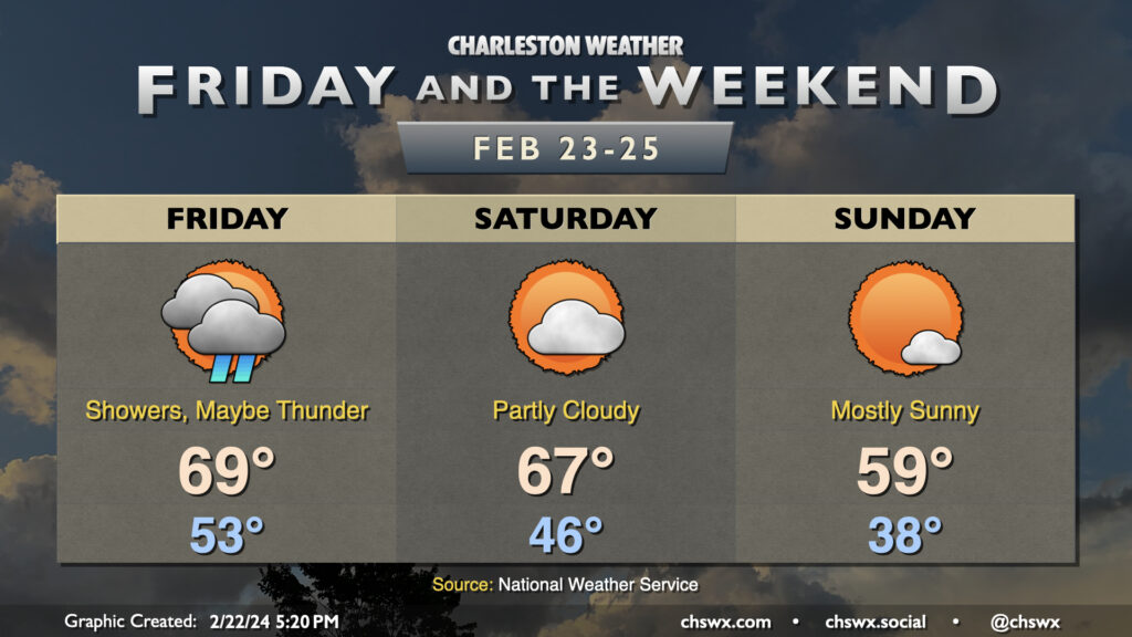
The first of two cold fronts to affect the area this weekend comes through on Friday, bringing showers to the area and maybe even a thunderstorm or two. It’ll be the warmest start to a day this week, with lows bottoming out only in the low 50s. Temperatures should warm to the upper 60s to around 70°, but the rain being around will make it decidedly less nice.
The first front clears the area in time for Saturday, which should be the warmer of the two weekend days. We start the day in the mid-40s while highs head to the mid-to-upper 60s once again under partly cloudy skies. Clouds will tick up as we head into Saturday afternoon and evening as the second front moves by, and there’s an outside shot at a shower or two as it moves through. This front will bring more of a cool shot of air to the area, with lows on Sunday bottoming out in the upper 30s and highs struggling to reach 60° under mostly sunny skies. The chill is short-lived, though: temperatures on Monday head into the upper 60s, while we’re well into the 70s by Tuesday as we close out February and climatological winter.
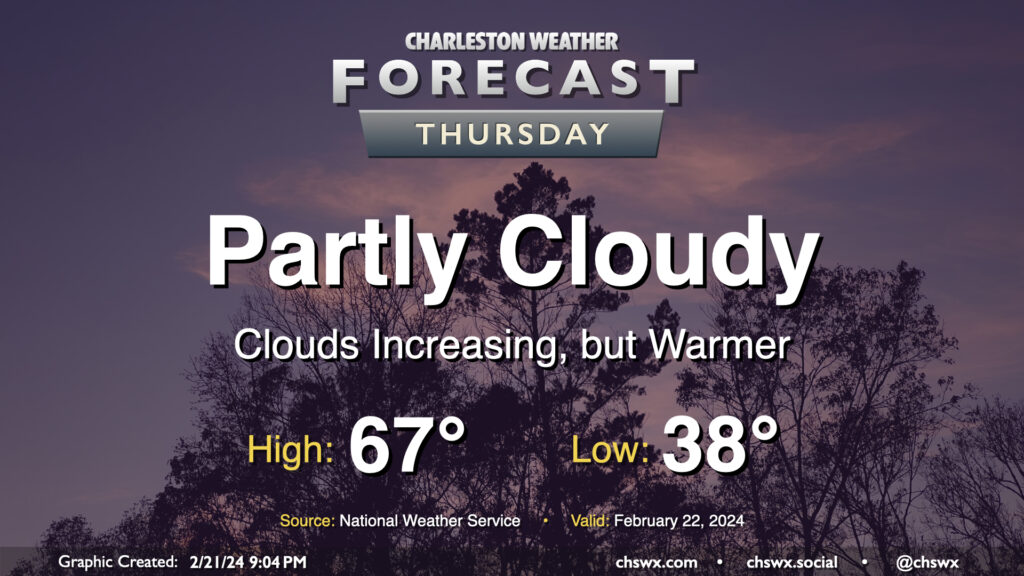
One more quiet day of weather lies ahead before a brief round of rain for Friday. Temperatures on Thursday start in the upper 30s — still running a little below normal for this point in February — but warm to the mid-to-upper 60s in the afternoon as southerly flow moderates the airmass a little bit more. We’ll start the day on the clear side, but clouds will gradually increase ahead of a cold front that’ll affect the area on Friday with the first shower chances in a few days.