The week ahead: A warm close to February and an unsettled start to March
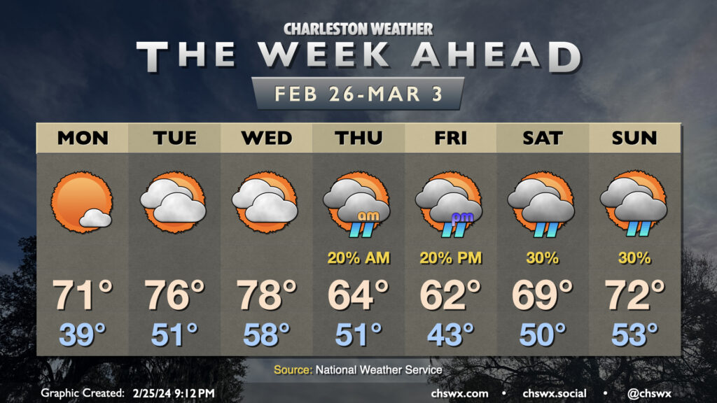
Sunday’s chill yields to a much warmer few days to start the new week and close out February. After a chilly start in the upper 30s, temperatures on Monday will rise into the low 70s, several degrees warmer than we reached on Sunday, thanks to plenty of sunshine and winds starting to go southerly as surface high pressure moves offshore. The warming trend continues for Tuesday and Wednesday, with lows in the low 50s on Tuesday yielding to highs in the mid-70s in the afternoon. Wednesday will start well above normal — think upper 50s — before temperatures make a run at 80° in the afternoon despite a mix of sun and clouds.
Cooling off and turning unsettled for the second half of the week
A cold front will come through overnight Wednesday, which could bring a few showers to the area for Thursday morning. The bigger impact will be to temperatures: after nearing 80° on Wednesday, temperatures will only top out in the mid-60s, making for more of a climatologically-appropriate Leap Day. High pressure will wedge into the area for Friday, keeping temperatures on the cool side of normal as we start March. Meanwhile, a disturbance moving in from the west could spawn low pressure offshore starting Friday afternoon into the weekend, but guidance is pretty far apart on if that happens. So, there is certainly a chance that we could see some rain late week, but how much and the timing remains very much to be seen. Stay tuned to updates as this forecast evolves.
Follow my Charleston Weather updates on Mastodon, Bluesky, Instagram, Facebook, or directly in a feed reader. Do you like what you see here? Please consider supporting my independent, hype-averse weather journalism and become a supporter on Patreon for a broader look at all things #chswx!