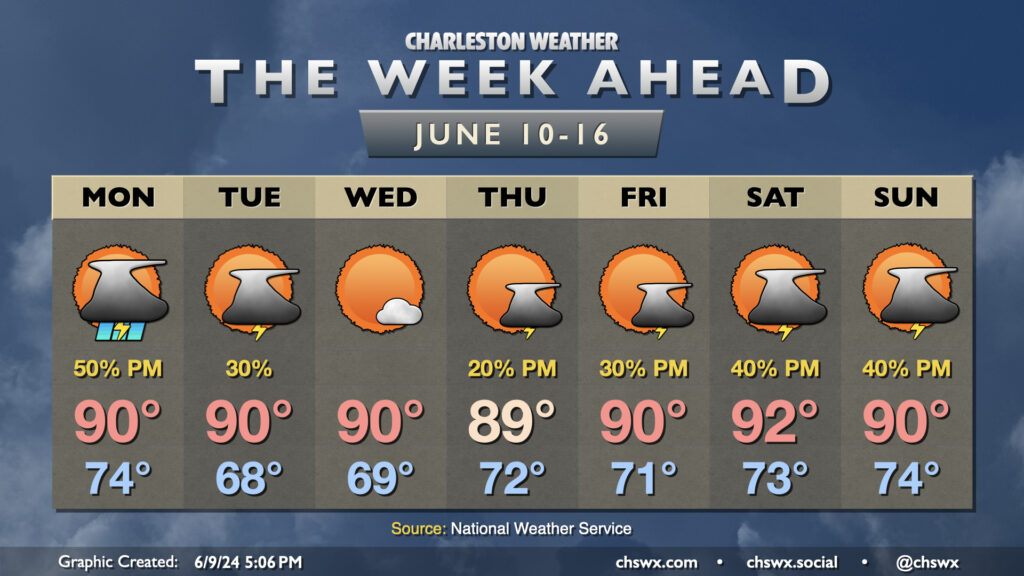
We may contend with a storm or two in the morning, but the weather story for Tuesday will be the return of the 90s in the afternoon. It’ll be a warm start with lows around 70°, but as the ridge aloft builds in, highs top out in the low 90s. If there’s one bit of good news here, it’s that it’s not summer-humid just yet, and dewpoints should run in the mid-60s, keeping heat indices reasonably in check. Cloud cover will be diminishing throughout the day as well, so expect plenty of sunshine as we get into the afternoon and evening hours.
The upcoming week will be on the warm side as ridging aloft builds in, sending mid-week temperatures well into the 90s and perhaps into record territory.
First, though, we deal with another round of scattered showers and thunderstorms for Monday. Temperatures on Monday start once again in the upper 60s to near 70°, warming to the mid-80s as one last upper disturbance makes its way through. We should see thunderstorms fire up around or a little after midday and generally remain scattered in nature. A few heavy downpours will be possible, and a strong storm can never be totally discounted near where boundaries collide — and on the flip side, some of y’all might not see any rain at all. (That time of year!)
Expect another round of scattered showers and storms on Sunday. Most of us could see rain at any point in the day. The best chances start closer to the coast in the morning and migrate inland during the afternoon, much as we saw on Saturday. It’ll be muggy, too: lows will barely get below 70°, while highs top out in the mid-80s as dewpoints continue generally in the mid-60s.
Once again, Sunday is not a washout threat, especially as you get closer to the coast. However, you’ll want to make sure your outdoor plans have a solid indoor backup. Remember: When thunder roars, go indoors!
A periodically unsettled weekend lies ahead as high pressure aloft gives way to a few disturbances rippling through the area. After another mild start in the mid-60s, Saturday will feature primarily isolated to scattered afternoon thunderstorms driven by the seabreeze. Temperatures will head into the mid-80s in the afternoon between any storms that fire. Overall, severe weather is not expected, but you’ll still want to take lightning into account for any outdoor plans you may have.
Sunday could feature perhaps slightly better coverage of showers and thunderstorms, but there is still no expectation of a total washout. Lows will bottom out just in the upper 60s, warming back to the mid-80s in the afternoon. Once again, you’ll want to make sure you’ve got a solid indoor backup for your outdoor plans, but don’t cancel anything, either. Just remember the old adage: “When thunder roars, go indoors.”
Get ready for another foggy start across much of the area Friday morning, as conditions appear favorable once again for some dense fog to develop and potentially have some commute impacts. Once again, if you’re encountering fog, slow down and use those low beams.
Once fog clears by mid-morning, expect generally partly cloudy skies with highs topping out once again in the mid-80s on Friday afternoon. A few inland spots could see a shower or storm, but the vast majority of us stay rain-free.
High pressure aloft will break down in time for Saturday, and some energy moving into the area will allow for isolated to scattered thunderstorms to break out particularly in the afternoon and early evening. It won’t rain all day in any one location, but having a backup indoor plan for your outdoor plans is a smart call. With the scattering of storms, expect highs to run a couple degrees cooler on Saturday, but still in the mid-80s. Sunday looks similar, with a slightly better chance of seeing some storms in the afternoon than on Saturday. Once again, expect lows in the mid-to-upper 60s to yield to mid-80s highs in the afternoon outside of thunderstorms.
From here, it turns hot…mid-90s may be in the cards by the middle of next week as we get a solid summer preview. (Whether that’s a good or bad thing is a thought exercise left to the reader.)