Weather much more becoming of June arrives this weekend as the upper low continues to pull away and we get a break in the action. We return to the 90s each day this weekend, with only a slight chance of afternoon thunderstorms on Saturday. Sunday could be even warmer, with highs approaching the mid-90s under partly cloudy skies. While a stray storm can never be totally ruled out, it’s looking like the vast, vast majority of us get Sunday in rain-free — some welcome drying out time after the soggy week that was.
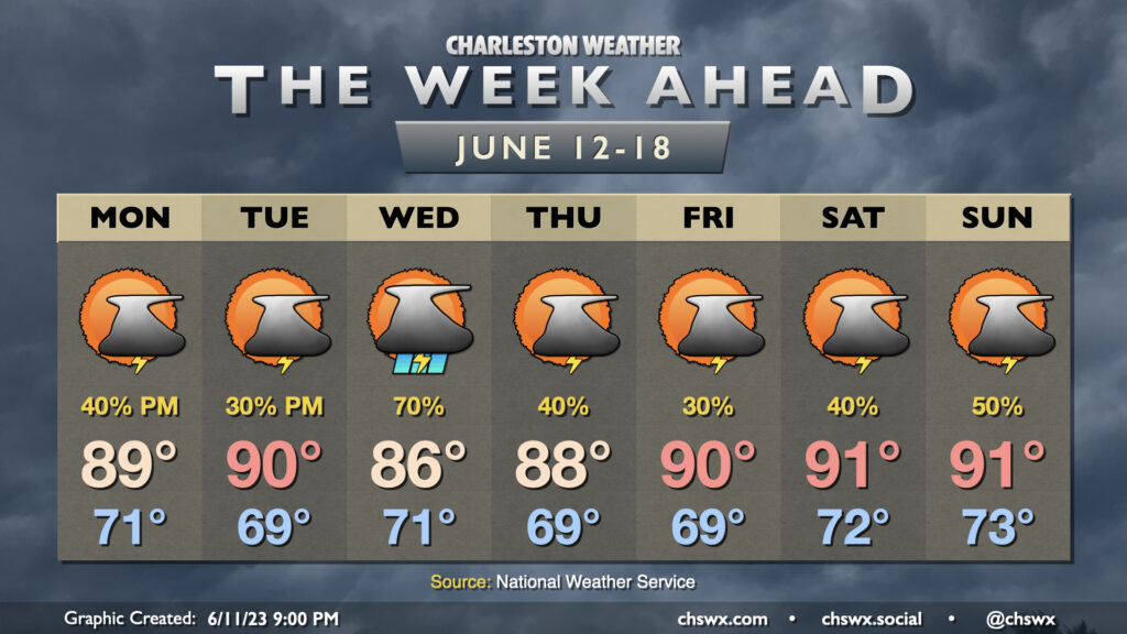
We will have one more day with off and on storms on Friday before improving weather arrives for the weekend. The blocking pattern that’s been plaguing us all week finally starts to dislodge, but a deep trough will remain across the area for Friday. This in conjunction with a front draped across the area will keep shower and thunderstorm chances in the forecast for pretty much any point during the day (though it will not be raining all the time, either). Some guidance this evening has been specifically hitting on some rainfall during the morning commute, so keep that in mind as you head out to work on Friday. Highs top out in the mid-80s with cloud cover and showers expected to be around once more.
The aforementioned upper low finally pulls away for the weekend. This will help move the front offshore and kick a little drier air into place starting Saturday. Highs top out in the upper 80s after we start the day in the low-to-mid-70s under partly cloudy skies, though a few thunderstorms should fire along the seabreeze in the afternoon (as is often the case during summertime). Sunday looks even quieter, with a such a low risk of a random shower or storm as to be unmentionable in the forecast. We should top out around 90° Sunday, and I suspect that’ll help get many folks out to the beaches, so use some patience as you may very well be dealing with traffic.
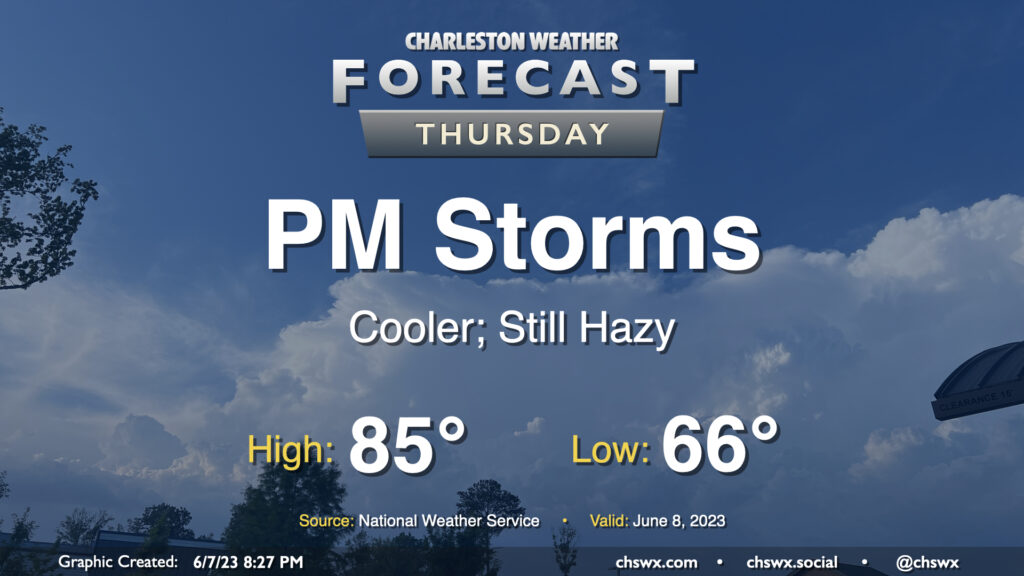
Thursday will be another active weather day across the region as a warm front draped across SC interacts with low pressure aloft to generate numerous showers and thunderstorms. A few of these storms could be on the strong side, with damaging wind gusts the main concern, though some hail can’t be ruled out either. Highs on Thursday top out in the mid-80s before storms get rolling once more. It won’t rain all day in any one spot, but when it does, it could be quite heavy. Keep rain gear handy, allow additional travel time, and keep an ear out for flood advisories as well.
The forecast for the rest of the work week will remain on the wet side especially Wednesday and Thursday before the upper low finally starts to dislodge from the blocking pattern on Friday. Until that happens, though, showers and thunderstorms will be possible at pretty much any point in the day, though the afternoons and evenings will be the favored time for storms given daytime heating. We’ll start each day in the low 70s before warming into the mid-80s before thunderstorms put a damper on temperatures. Friday does look a little less soggy with a little more in the way of scattered vs. numerous storms, and that pattern should continue to improve heading into the weekend. Stay tuned for updates as things continue to evolve.
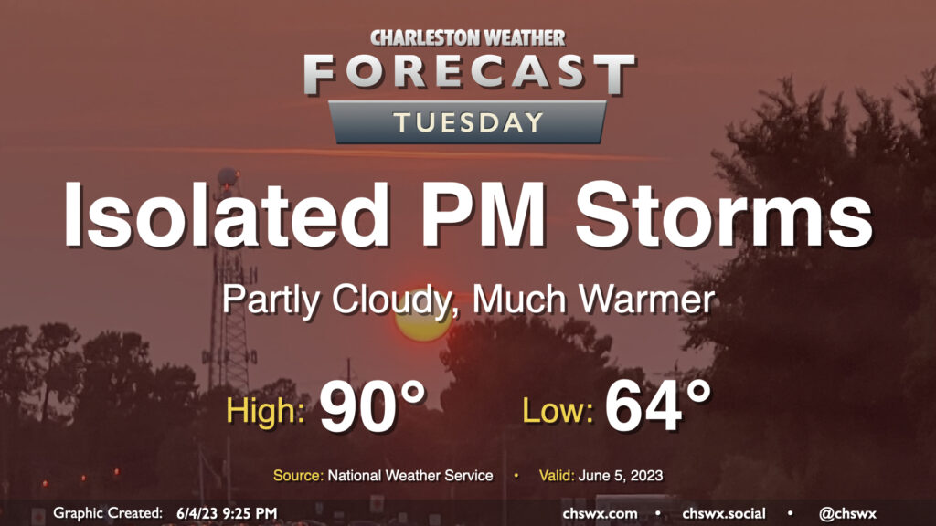
Showers and thunderstorms remain in the forecast for Tuesday and beyond as a Rex block (high pressure to the north, low pressure to the south) sets up across the area, feeding in plenty of moisture and sufficient forcing to keep things quite unsettled. Expect the day to start out in the upper 60s to around 70° before warming to about the mid-80s before storms get going. There’s the potential we could even be dealing with some showers and storms advancing through the area in the morning if some of the high-resolution guidance is correct, too, but the best chance for showers and thunderstorms will arrive in the afternoon. Bottom line: Keep the rain gear handy throughout the day, and be patient getting to where you’re going.
We have an unsettled week of weather ahead as an upper low cuts off across the Southeast, blocked in by high pressure to the north — much as we saw at the start of the month, in fact, though we’ll do without the highs in the 60s this go-around.
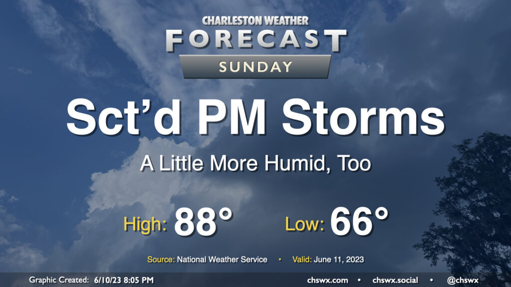
We have another warm day in store for Sunday, though with a better shot at an afternoon or evening thunderstorm. We start the day in the low 70s before warming into the upper 80s with a little more humidity than we saw on Saturday. (Hopefully a little less smoke, too.) Temperatures could feel a little warmer, generally around 90° or so, when factoring in the humidity.
With a little more available moisture, so it goes with instability. We could see the seabreeze get a little more active than it did on Saturday across the area, with scattered showers and thunderstorms possible in the afternoon and evening hours. Not everyone sees storms, so don’t cancel plans — just be ready to move indoors if a thunderstorm approaches.
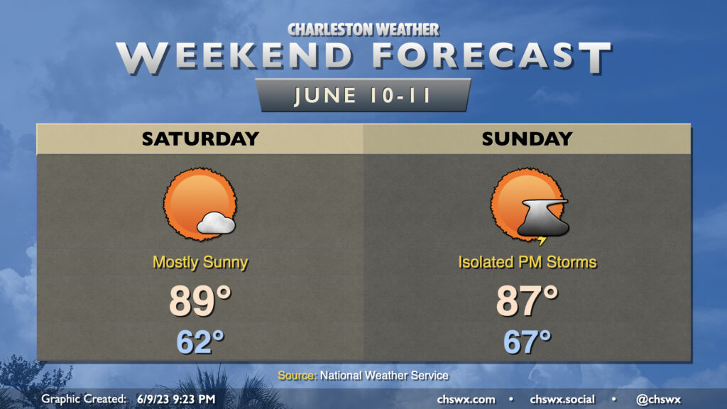
This weekend is looking mostly quiet (weather-wise, anyway). Expect standard mid-June fare across the Lowcountry with highs topping out around 90° each afternoon. Saturday will feel a little drier than we’d normally feel at this point in the year, in fact, with dewpoints mixing out to around 60° in the afternoon. We may see an isolated storm later in the evening, but the vast majority of us stay dry.
It stays mostly that way for Sunday, though we’ll feel a little more in the way of humidity with winds turning more onshore. Once again, a stray afternoon storm is possible, but overall we look to get much of the day in rain-free. Expect highs to once again top out around 90°, with heat indices in the low 90s.
A stretch of quieter weather begins Friday and lasts through the weekend, in what is a bit of a role reversal for 2023. A few showers could be around the area Friday morning, but those will get out of here by mid-morning and we should stay largely quiet for the rest of the day. Highs head to around 90° in the afternoon under partly cloudy skies.
Saturday and Sunday will both be pretty solid mid-June days: we’ll start each day in the low 70s and top out in the low 90s each afternoon under partly cloudy to mostly sunny skies. A stray shower or storm may be possible well inland — one can never totally rule that out especially with a trough still hanging around — but otherwise, it’s looking good, and I hope you can take advantage.
Another round of scattered to numerous showers and thunderstorms is expected Thursday, particularly in the afternoon and evening as daytime heating and some upper-air help kicks in, though a shower or storm will be possible for much of the day. Before storms fire, expect to start the day in the upper 60s, warming to the mid-80s under a mix of sun and clouds. Dewpoints around 70° will yield heat indices around 90°.
The risk for severe weather is looking a little lower than it did on Wednesday, with the best risk displaced to the south, but a storm with a damaging wind gust or two and some hail can’t totally be ruled out.