Rest of the work week: Temperature rollercoaster

We’ll add a little amplitude to the temperature rollercoaster as we get into the second half of the work week as one high pressure departs and another builds back in.
Read more »Forecast explanations, atmospheric science, and other cool weather-related stuff for Charleston, SC
We’ll add a little amplitude to the temperature rollercoaster as we get into the second half of the work week as one high pressure departs and another builds back in.
Read more »
A shot of cold air will drive temperatures back below freezing for Tuesday morning, with some upper 20s likely inland. The metro area should stay closer to the low 30s, but tomato, tomahto — it’s just gonna be cold. A decent northerly breeze will drive wind chills down into the mid-20s, too. Make sure you’ve got pets and plants in a safe and warm place overnight. Temperatures will struggle to the upper 40s at best in the afternoon despite plenty of sunshine, indicative of just how frigid of an airmass we’ve got to work with on Tuesday. Bundle up!
Read more »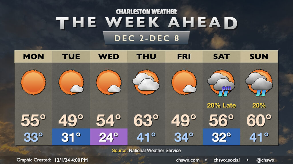
Seemingly on cue for climatological winter, temperatures will remain below normal pretty much all week, with a couple reinforcing shots of cool air to keep us honest interspersed throughout. We stay mostly rain-free, with the possible exception of later Saturday night into Sunday as another front with a few showers looks to move by.
Read more »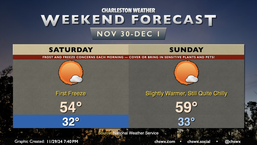
Bring in your pets and sensitive plants (or cover them if you can’t bring them in) as the first freeze of the season is expected tonight into Saturday morning to close out climatological fall and welcome in climatological winter on December 1. Temperatures will fall into the low 30s across much of the metro by morning, and a Freeze Warning is in effect for the entire Tri-County area as a result. Despite several days of cold air ahead, including even colder air next week, this will be the only Freeze Warning of the season as the growing season will come to an end on December 1, regardless of how far to the east freezing temperatures penetrate. Frost and freeze alerts resume on March 1, 2025.
After that very chilly start, we’re warming to only the mid-50s in the afternoon despite mostly sunny skies. Northerly winds 5-10 MPH will keep temperatures feeling like the mid-40s through early afternoon.
Winds go calm overnight Saturday into Sunday morning, and we’ll see another very chilly morning as a result, with the potential for widespread frost particularly inland. Lows should bottom out in the low 30s once more. (If it doesn’t freeze again, it’ll be close.) Highs will recover a bit to the upper 50s on Sunday afternoon, but that’s still well below normal for the first of December.
We have another shot of even colder air in store for early next week, with lows in the 20s across the metro possible Tuesday and Wednesday mornings. Tuesday may not even get out of the 40s! Colder-than-normal temperatures and rain-free conditions look to continue through next Friday.