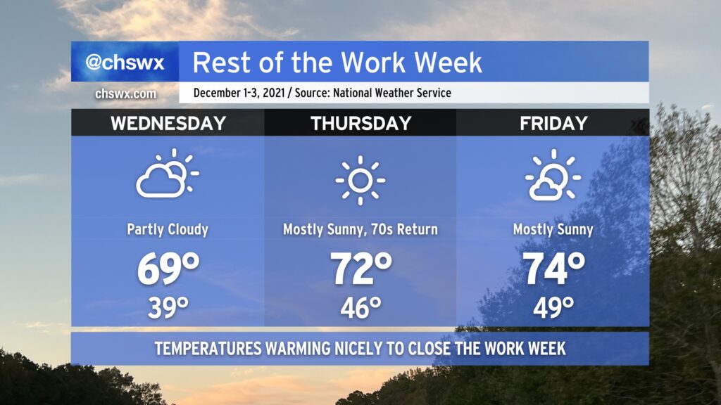
Meteorological winter begins tomorrow, running from December 1 through February 28, 2022. It sure won’t feel like it, though: temperatures will warm to near 70° on Wednesday, and then peek into the low to mid-70s on Thursday and Friday. We’ll have some cloud cover associated with a weak disturbance aloft Wednesday, but other than that, expect quite a bit of sunshine over the next few days.
The only weather concern looks to be a small risk for minor coastal flooding beginning with Friday morning’s high tide as we head toward the new moon phase. So far, the NWS forecast has that tide peaking just shy of 7’, which is the minor coastal flooding criteria. Peeking a little further down the road, guidance indicates that Saturday morning’s high tide may scrape that 7’ threshold as well. So far, though, it certainly does not appear to be a repeat of the last new moon, which brought us top-15 tides during the first week of November.
Finally, we bid adieu to the 2021 hurricane season, which was another extremely busy season in terms of named storms (21). For the second consecutive year, the primary storm name list was exhausted — but we did not have to crack open the supplemental list, at least. Once again, our luck has held here — aside from the quickly-developing Tropical Storm Danny and the nocturnal tornado outbreak associated with Tropical Storm Elsa, it was another rather quiet season for the Lowcountry, and for that I am grateful.
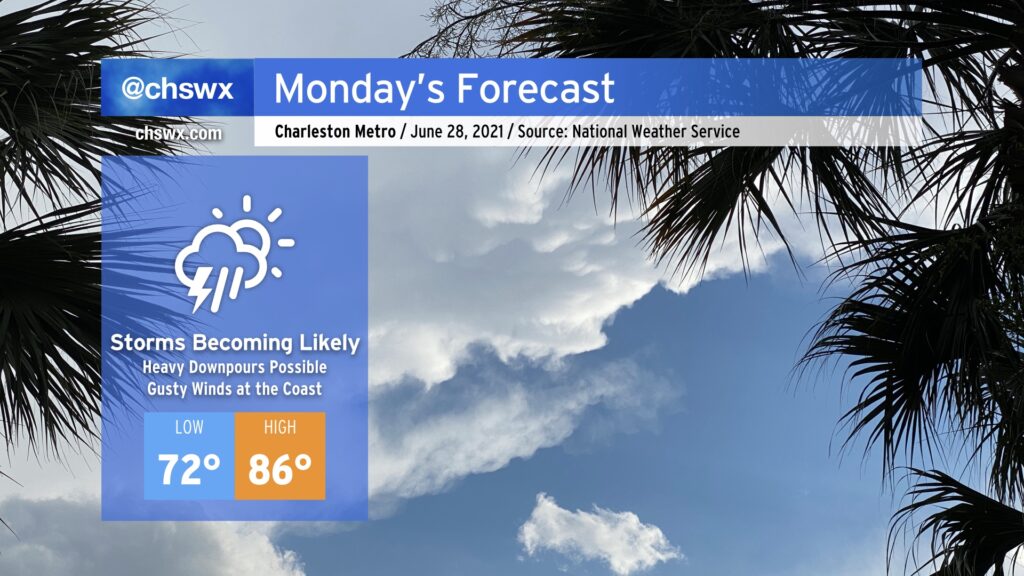
Get ready for periods of showers and thunderstorms tomorrow with heavy rain and gusty winds at the coast as a tropical disturbance of some kind comes ashore south of the Charleston metro area in the afternoon. While it’s unclear what state the disturbance will be in by the time it arrives tomorrow, the impacts are largely expected to remain the same.
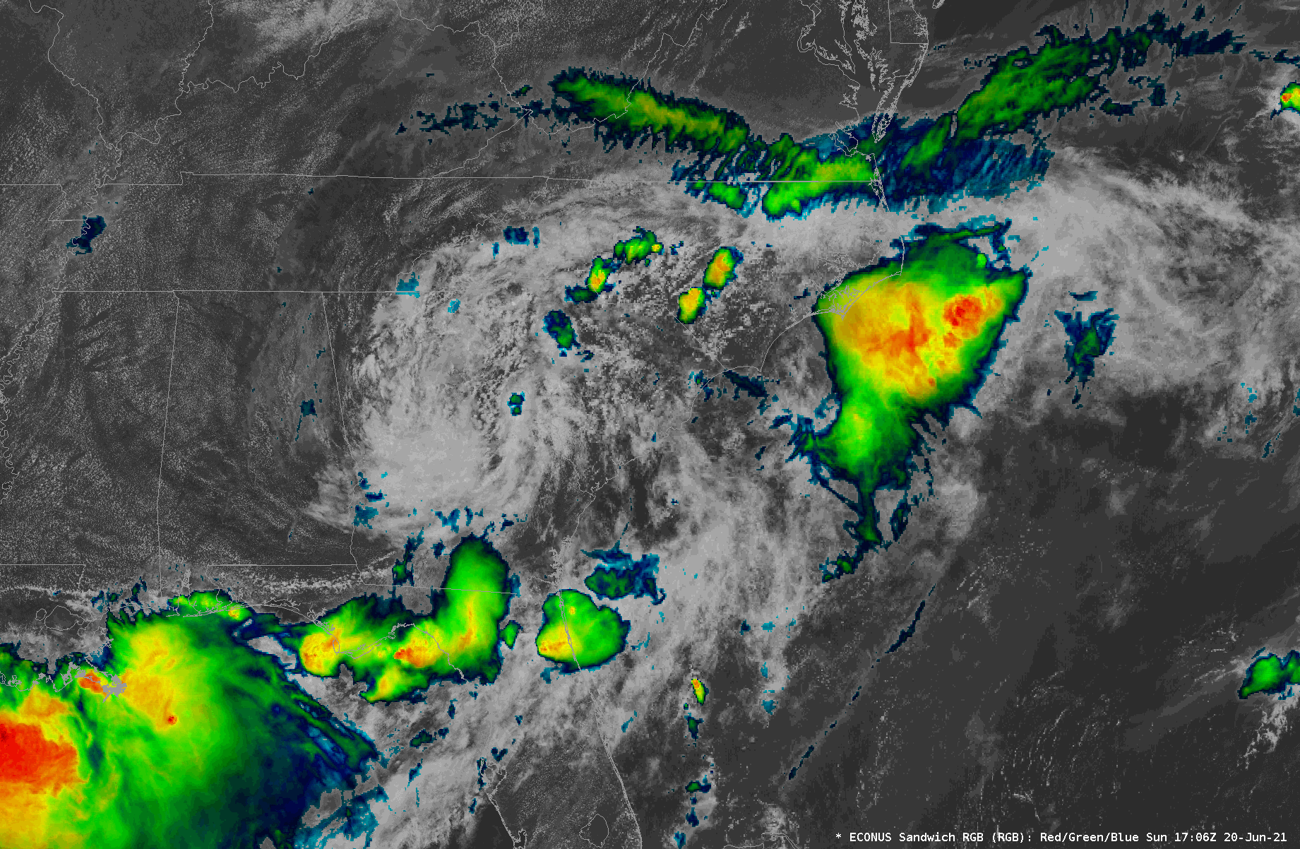
We continue to watch Tropical Depression Claudette’s circulation move through northern Georgia into the Upstate and Midlands of South Carolina this afternoon. NHC’s last fix at 2PM had it roughly around Athens, GA, heading east at 17 MPH. So far, a few spots have seen some brief rainfall, but we have been largely within a dry slot surrounding the inner bands of the circulation. Indeed, it appears that moisture inflow may have been disrupted in part due to vigorous thunderstorms along the Gulf Coast — a common occurrence for choking off more widespread rainfall in our neck of the woods. However, we continue to watch a decent rain band stretching from roughly Mt. Vernon, GA up toward Augusta. This band is steadily making eastward progress, and satellite data suggests it could be becoming a little more vigorous as it moves eastward into a more unstable atmosphere.
A blend of timing tools and model guidance puts this rain band in the Charleston Tri-County area roughly in the 4-6 PM timeframe. It will undoubtedly bring the greatest risk for very heavy rainfall, with models suggesting 1-2″ of rain will be common. 3″+ cannot be ruled out in some spots, either, and wherever this heaviest rain falls could be in line for flooding issues.
High tide is at 4:55 PM. Right now, it appears that the heaviest rain will arrive about an hour or two afterward, but trends will need close monitoring. I would still be prepared for flooding this evening in downtown Charleston.
We’ve had gusty winds in the area thanks to a strong low-level jet — a gust to 32 MPH was recently recorded at Charleston International Airport. Guidance suggests the core of the low-level jet looks to move atop the SC coastline around the time the rain band is moving in, so that could increase the risk for a damaging wind gust or two. This strengthening low-level jet will also assist in creating favorable conditions for a tornado or two, so we’ll want to monitor these trends as we go throughout the day.
Stay weather aware — more updates here and on Twitter as needed.
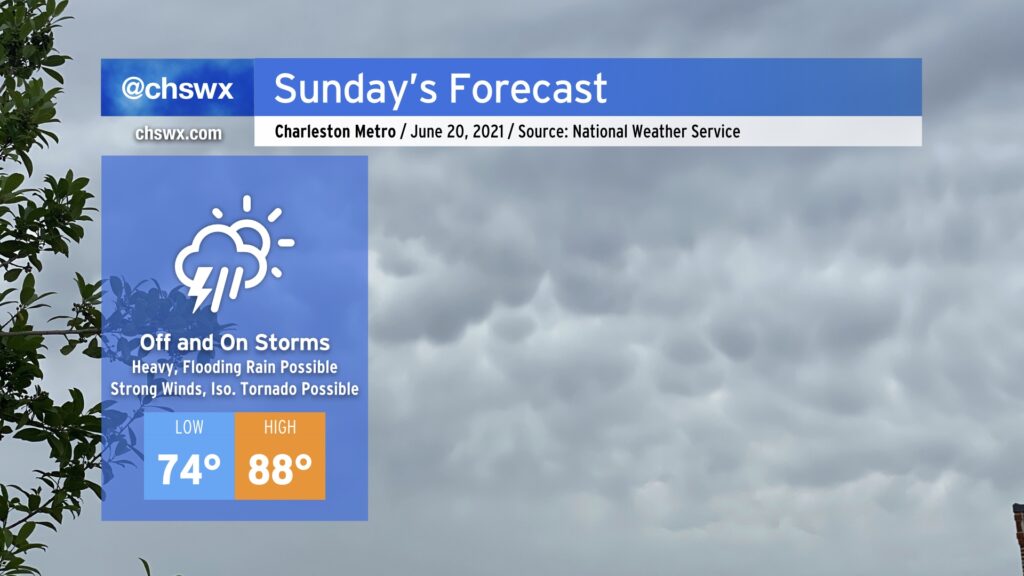
Tropical Depression Claudette, which is moving through western Alabama this evening, will be taking a bit more of an easterly turn around the subtropical ridge, heading through northern Georgia and SC during the day on Sunday. This will, in turn, bring along another plume of tropical moisture into the area, setting up another round of heavy and perhaps flooding rain in spots, along with the risk for strong to severe thunderstorms with damaging wind gusts and maybe a tornado or two.
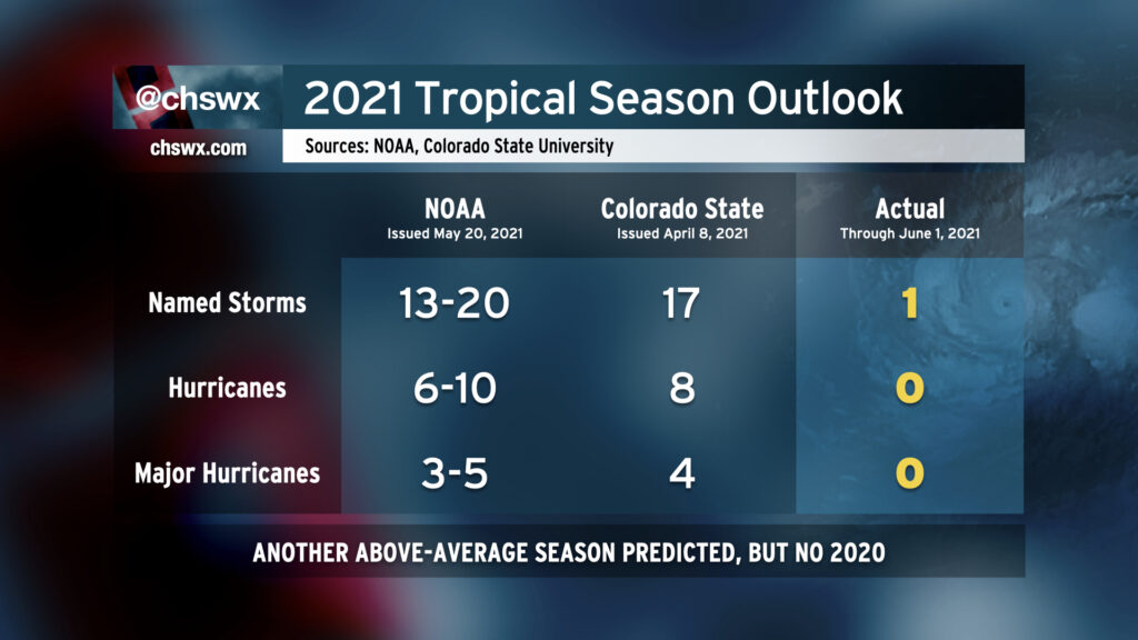
Well, friends, it’s that time of year again: The Atlantic hurricane season begins today and runs through November 30. Seasonal forecasters from Colorado State University and NOAA are calling for another above-average season when considering continued warm sea surface temperatures and ENSO-neutral conditions (read: no La Niña nor El Niño is expected). While a repeat of the sheer volume of the 2020 hurricane season is unlikely, it still looks to be busy out there.
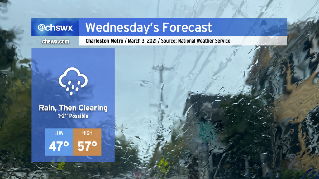
Expect a soaking rain to pick up overnight and last through early Wednesday afternoon. Rain totals should end up being around 1-2″ across much of the Tri-County with locally heavier amounts. If there’s a piece of good news in this, right now it appears that the heavier rain is going to miss our next two times of high tide (10:33 PM Tuesday, 10:49 AM Wednesday). Salt water flooding remains a concern around times of high tide, though, with a Coastal Flood Advisory until midnight as the 10:33 PM high tide will approach 7′ in the harbor. If rain does pick up around that time, there could be more trouble on area roads, so be aware of that possibility through tomorrow.
Low pressure will depart the area Wednesday afternoon, which will shut the rain off and allow skies to begin to clear out. Depending on the timing of the clearing, we should see temperatures rise to the mid-to-upper 50s in the afternoon, setting up a rather nice Thursday with clear skies and highs in the mid-60s.