Tropical disturbance to bring heavy rain and gusty winds to the Lowcountry tomorrow
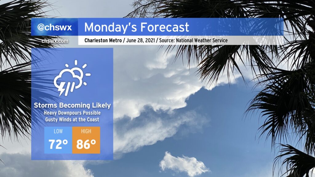
Get ready for periods of showers and thunderstorms tomorrow with heavy rain and gusty winds at the coast as a tropical disturbance of some kind comes ashore south of the Charleston metro area in the afternoon. While it’s unclear what state the disturbance will be in by the time it arrives tomorrow, the impacts are largely expected to remain the same.
Latest on the tropical disturbance
As of 8PM, NHC has not yet initiated advisories on the tropical disturbance in the southwest Atlantic. There certainly is evidence of a closed low on satellite, and a recent microwave pass may indicate some banding features trying to develop. However, wind shear is pretty consistent in displacing the thunderstorms to the west of the center, which is disrupting much in the way of organization right now. The storm has yet to reach the Gulf Stream, though, and could yet become classified as a depression or even Tropical Storm Danny before it comes ashore tomorrow afternoon, probably somewhere between Brunswick, GA and Edisto Beach.
If the storm should be classified as a tropical cyclone, it is conceivable that we could see Tropical Storm Warnings hoisted for a short time along our coastline tomorrow. Regardless of whether warnings are required, impacts look to remain largely the same, with rain the main weather feature to affect much of the area.
Heavy rain and flooding threat
As usual with weak tropical disturbances, heavy rain and isolated bouts of flooding are the most concerning threats, and are absolutely what you should be most on guard for tomorrow. High-resolution guidance has generally placed the bullseye of the best heavy rain chances south of the Tri-County area (particularly in the Savannah, GA region), but there will still be the potential for a half-inch to an inch of rain across our neck of the woods with locally higher amounts in heavier tropical downpours. If the storm tracks a little further north than is depicted in a lot of the guidance, then our heavy rainfall and flooding threat increases.
We will want to watch the 11:45 AM high tide carefully in case heavy rain coincides a couple hours in either direction. It does not appear that salt water will become a major factor as the daytime high tide will be the lower of the two tides, and the peak surge should be arriving as the tide heads out. However, as June has reminded us all too frequently, it doesn’t take much rain to cause problems downtown. Thus, it’s something to watch, but the probability of a long-duration flood event is quite low at this point. Again, a more northerly storm track would increase our risk for flooding problems, so this will continue to be monitored.
Wind threat mostly at the coast
Winds will not play a major role in this event outside of at the coast, where gusts 20-30 MPH will be common. This northeast to easterly wind combined with increased swell will enhance the risk for rip currents at area beaches. Otherwise, do not expect too many issues with the wind. We could see some gusty winds further inland within some heavier rain showers, but as of this writing, nothing is pointing to a substantial risk of wind-related issues. Additionally, despite being on the northern side of the system, tornadoes do not appear to be a concern outside of the NAM model, which always gets a little too excited about these kinds of things.
Bottom line
- There are tropical systems that threaten our area from time to time that are legitimately “scares.” This is certainly not one of them, even if warnings are hoisted.
- Named or not, focus on the impacts, because that’s what matters and won’t change regardless of classification: Periods of heavy rain, gusty winds at the coast, and the potential for isolated bouts of flooding.
- This is nothing we can’t handle! In fact, I suspect that many of you will find some of this past month’s summer thunderstorms to be far more disruptive than tomorrow’s storm.
I’ll have more updates tonight if needed, otherwise, see you first thing in the morning!
Follow my Charleston Weather updates on Mastodon, Bluesky, Instagram, Facebook, or directly in a feed reader. Do you like what you see here? Please consider supporting my independent, hype-averse weather journalism and become a supporter on Patreon for a broader look at all things #chswx!