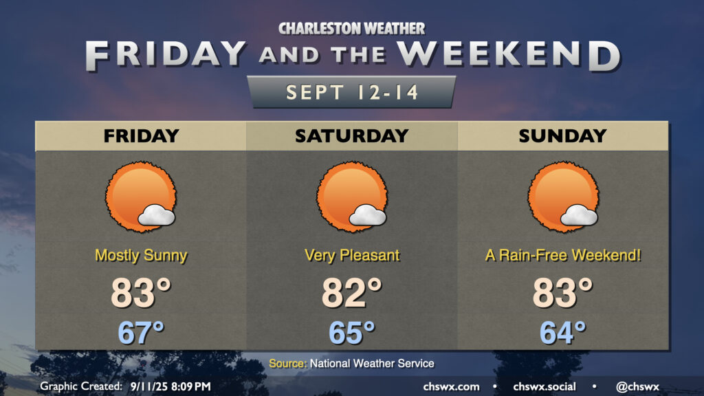
More sunshine will show itself starting Friday and lasting into the weekend courtesy of continued high pressure and northeasterly winds keeping a feed of cooler and drier air coming in. All in all, we can expect lows in the mid-60s each morning, with highs peaking in the low to mid-80s in the afternoon. Fun fact: This looks like the first weekend since July 26-27 without at least a trace of rain at either of the climate sites, so suffice it to say, we are very, very due for a quiet weekend of weather.
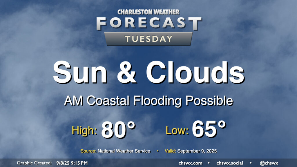
Another quiet weather day is ahead as high pressure wedges across the area from the northeast. Expect a mix of sun and clouds with comfortable temperatures. We start the day in the mid-60s, warming to about 80° in the afternoon. It’ll be a bit breezy, with winds gusting around 15-20 MPH especially near the coast. These northeasterly winds will continue to drive tidal departures in Charleston Harbor above flood stage, and we should see minor to moderate flooding with the 9:35 AM high tide. Some flooding may have impacts on the tail end of the commute, so be prepared for delays if downtown is your destination.
A front which helped stir up another round of heavy rain and flooding in downtown Charleston on Sunday will clear the area overnight into early Monday, yielding a week of comfortable temperatures with occasional slight shower and storm chances.
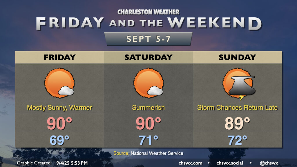
Warmer and a little more humid air will return to the area Friday as winds go more southerly. With high pressure remaining in control for a few more days, though, we’ll stay largely quiet weather-wise this weekend before a front starts to affect the area later Sunday.
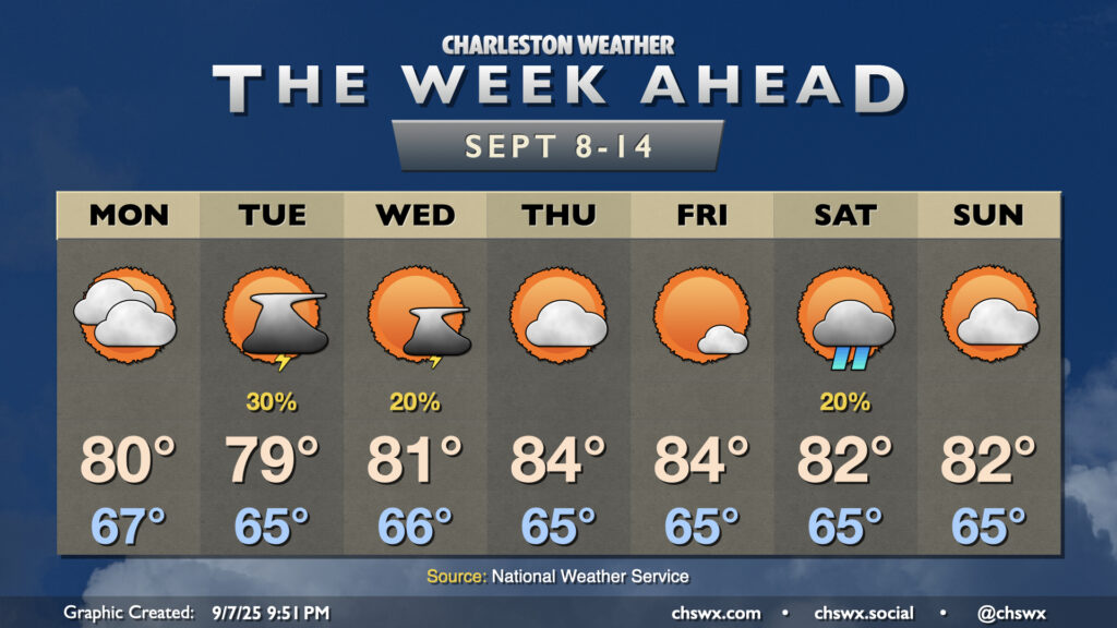
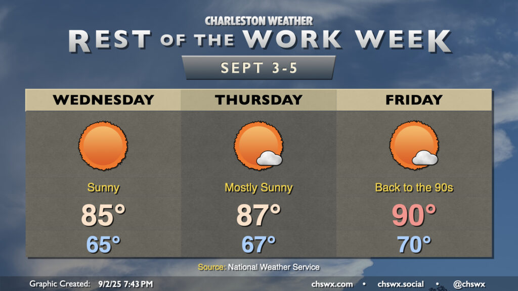
The rest of the work week will remain generally quiet (weather-wise, anyway), as high pressure remains in control at the surface. Temperatures will be on a warming trend as we get over the hump and into the second half of the work week as the mid-level trough that’s kept us on the cool side flattens out and retreats a bit north. We’ll also start to see high pressure build back in from the Atlantic for a few days, which turns the flow at the surface more southerly and starts to bring that more warm and humid air back to the area. We’re in the mid-80s Wednesday, upper 80s Thursday, and likely back to around 90° on Friday, with lows steadily climbing with the dewpoints back to around 70° by Friday morning. However, we look to stay rain-free through about Saturday before another front approaches for late weekend/early next week.
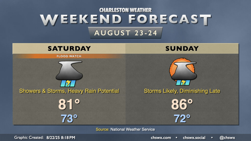
After record-breaking rainfall on Friday, more heavy rain appears likely for Saturday and to a lesser extent on Sunday as waves of low pressure along a stalled front continue to traverse the area, which has been well-moistened by an influx of tropical air.
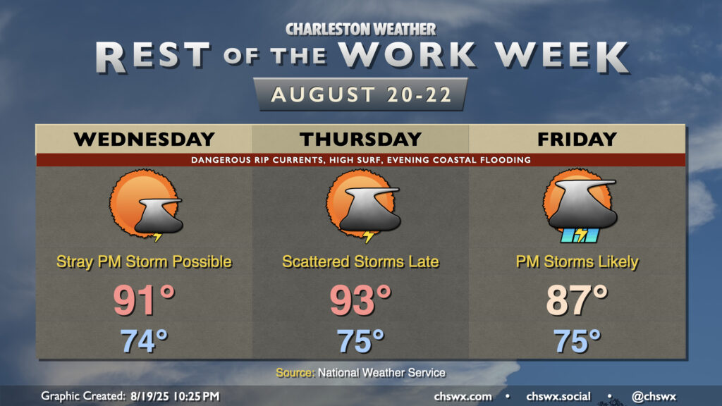
The main story for the next couple days will be Hurricane Erin’s impacts on the Lowcountry. While not a direct hit — the storm will pass hundreds of miles offshore — the strong, dangerous rip currents and high surf will cause beach erosion and coastal flooding issues over the next few days.
High pressure will be the main weather feature for the next few days, with comfortable warmth and plenty of sunshine expected through Thursday before the next isolated storm chance arrives Friday.
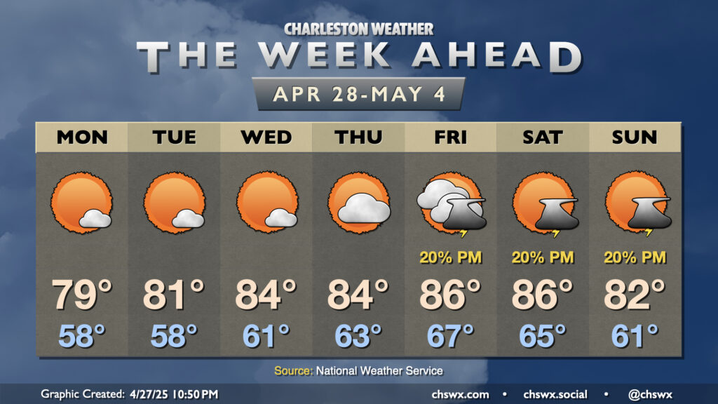
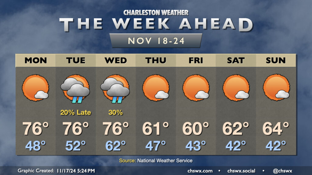
The week ahead gets off to a warm start, but some seasonably cool weather featuring temperatures a few clicks below normal sets in for the second half of the week.
Monday starts with temperatures in the upper 40s. As high pressure begins to shift offshore, we’ll start to see temperatures warm back to the mid-70s in the afternoon under mostly sunny skies. We’ll have one more round of coastal flooding in the morning, but it will not be nearly as severe as what we’ve seen the past few mornings as water levels should only peak around 7.2′ with the 9:31am high tide. Still, expect a few road closures in the more vulnerable trouble spots downtown for a few hours during the commute. From there, winds go more unfavorable and the astronomical impacts from the recent full moon continue to lessen.
The only period of unsettled weather looks to take place later Tuesday through Wednesday as a front comes through (the impetus for our cooldown beginning Thursday). Much of Tuesday should get in rain-free, but will be well on the warmer side of normal with lows in the low 50s yielding to highs in the mid-70s in the afternoon. Shower chances increase around and after sunset, and hang around through midday Wednesday. We’ll see cloud cover diminish as Wednesday goes on, but lagging cooler air will let temperatures back to the mid-70s for one more afternoon after an abnormally mild start in the low 60s.
Cool air begins to kick in overnight Wednesday, and we’ll start Thursday in the upper 40s. Highs on Thursday, though, will struggle above 60° despite considerable sunshine. We’ll repeat this performance on Friday, with an even cooler start in the low 40s. A slow warming trend begins over the weekend, but expect temperatures to remain below normal with highs in the low to mid-60s and lows in the low 40s each day with plenty of sunshine throughout.
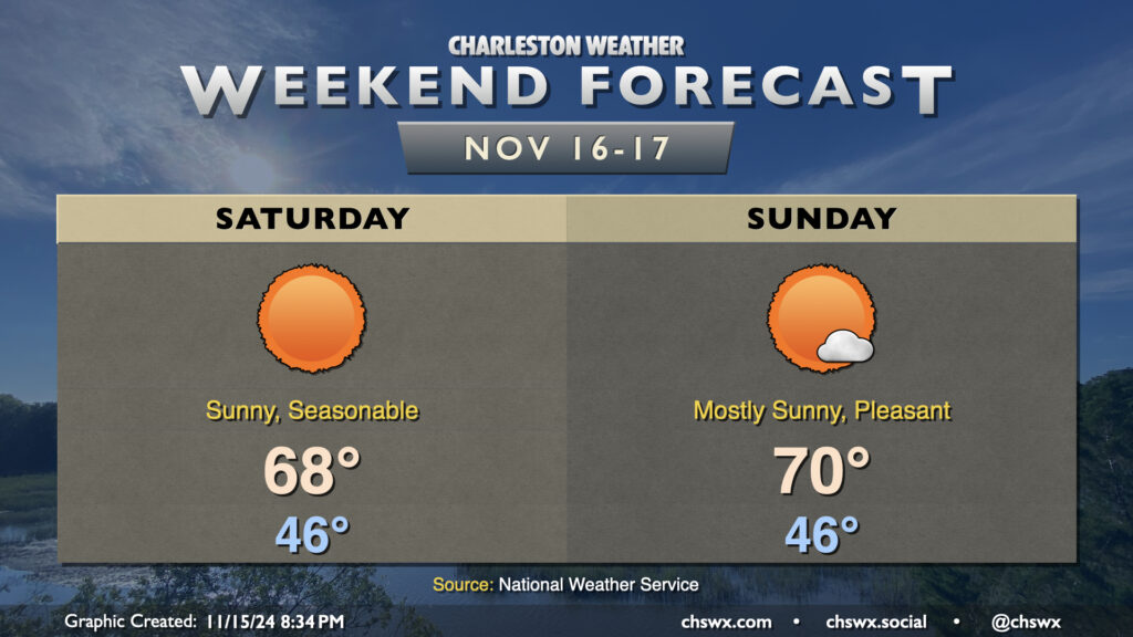
Cool high pressure will be in control this weekend, and we will get a taste of more seasonable conditions for mid-November than we’ve had thus far this month.
First, though, there is the potential for major coastal flooding for the second time in three days with Saturday morning’s high tide, which is predicted around 7:46am. Water levels in Charleston Harbor are projected to peak between 8.1-8.3′ MLLW with this tide, and this will cause numerous road closures throughout downtown Charleston, as well as flooding issues on Isle of Palms, Mt. Pleasant, and perhaps even parts of James Island. Be vigilant and be ready to reroute in case you encounter a flooded road. A Coastal Flood Watch is in effect between 6-10am, and if trends continue, expect this to be upgraded to a Coastal Flood Warning. Also, if the predicted forecast height of 8.2′ comes to pass, it’d be a top-25 tide on record at Charleston Harbor.
Water levels should diminish by mid-morning, and from there, a fairly nice Saturday commences. Expect quite a bit of sunshine, with temperatures warming from the mid-40s in the morning to the upper 60s in the afternoon, just about right on target for normal for this point in the year. Sunday should turn a touch warmer, but a high of 70° is just a teeny bit warmer than normal, so that seasonable feel will continue. Unfortunately, another round of moderate to major coastal flooding is possible with Sunday morning’s high tide, though it should not be as severe as Saturday’s.
From there, a warming trend commences for the first half of the week before a mid-week front. The second half of next week looks much cooler than normal, with highs possibly not making it out of the 50s next Thursday! But let’s enjoy the weekend first.