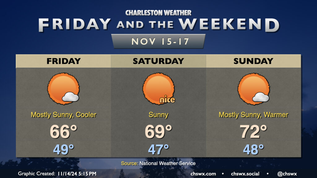
Showers scour out overnight Thursday, and by Friday morning, clouds will be diminishing as cooler and drier air works into the area. We’ll start the day in the upper 40s to around 50°, while the continued influx of cooler air will keep highs pinned to the mid-60s despite increasingly full sunshine. The only fly in the ointment will be the risk for minor to moderate coastal flooding around high tide, which should peak just before 7am. Water levels between 7.3-7.5′ are forecast, which will close some roads, though not as extensively as we saw Thursday morning.
Seasonable and quiet conditions continue for the weekend. Saturday should be a particularly nice day, with lows in the mid-40s yielding to highs in the upper 60s to around 70° in the afternoon, while temperatures turn a little warmer for Sunday as highs get to the low 70s after another upper 40s start. Sunshine will be very prevalent throughout the weekend, and I hope you get a chance to take advantage of weather that feels much more appropriate for mid-November.
Coastal flooding concerns will continue into the weekend, though, with major flooding expected with Saturday morning’s high tide as water levels are expected to peak around 8-8.2′ with the 7:46am high tide. Expect another round of numerous road closures in downtown Charleston on Saturday morning. Moderate to potentially major flooding can’t be ruled out for Sunday morning, either, as water levels once again approach 8′. Keep an ear out for Coastal Flood Watches, Warnings, and Advisories from the National Weather Service as your signal that travel could turn difficult.
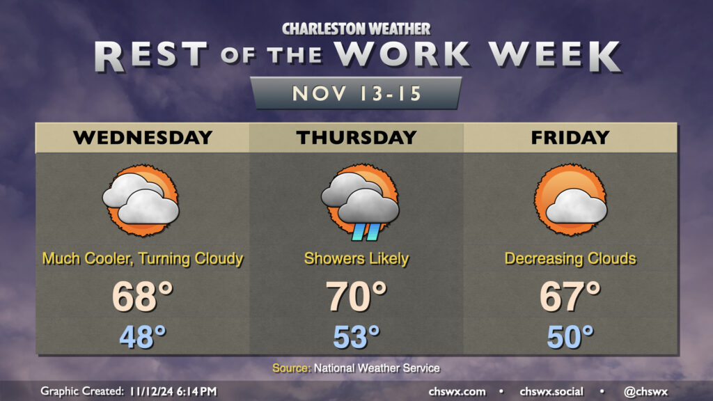
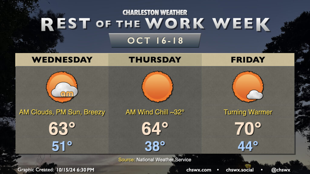
Cooler and drier air will push in overnight as high pressure wedges into the area from the north. This will make for a much cooler day on Wednesday than we’ve had in quite some time, with lows in the upper 40s in many spots away from the coast expected in the morning. High temperatures should only peak in the upper 60s as cooler air moves in. Increasing cloud cover as the day will also assist in keeping temperatures a little lower, too.
High pressure will break down Thursday as a cold front approaches, driving up the risk for showers particularly from midday into early evening. We’ll start the day in the low 50s, warming to around 70° in the afternoon. Rain should generally be on the light side, though some pockets of heavier rain can’t be totally ruled out, either.
The front clears the area for Friday, and cloud cover scours out during the day as a result. Temperatures, though, will once again struggle to the mid-to-upper 60s as cool air behind the front continues to push in. This sets the stage for a seasonably nice weekend, though, with lots of sunshine expected. Expect highs in the upper 60s Saturday, with low 70s returning for Sunday, right around where we should be at the midpoint of November.
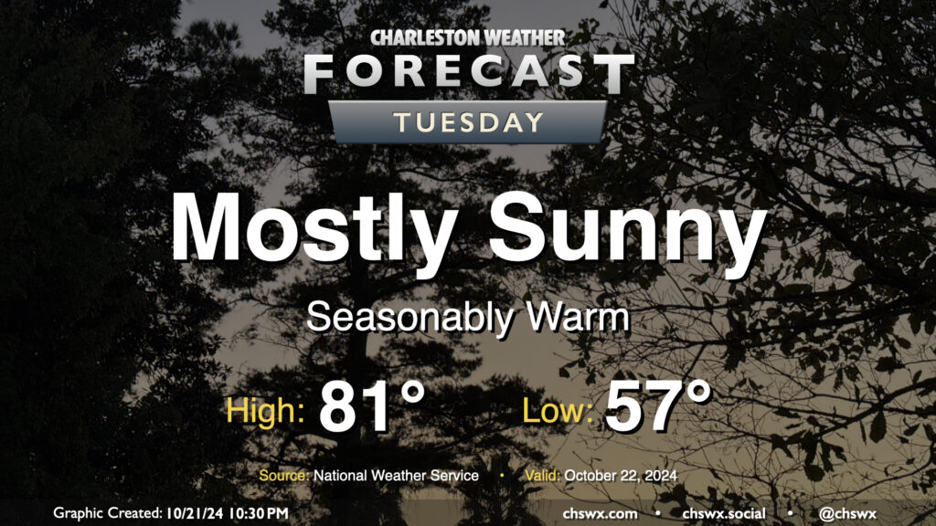
The status quo continues for our weather on Tuesday, and with the way things have been going, that’s not necessarily a bad thing. Expect to start the day in the mid-to-upper 50s (warmer near the coast), warming to the low 80s in the afternoon under mostly sunny skies. (The normal high for October 22 is 76°, so we’ll be running a few degrees above climatology.) We’ll have a little bit of a northeast breeze once again, but nothing too bad.
The high tide at 12:45 PM should fall short of the 7′ flood stage in Charleston Harbor, though it’ll be a bit of a close call. We may still see some salt water encroach onto some of the more vulnerable roads as a result. Otherwise, that’ll do it for this cycle of coastal flooding. The next new moon arrives November 2, and we’ll watch around that time for additional coastal flooding concerns.
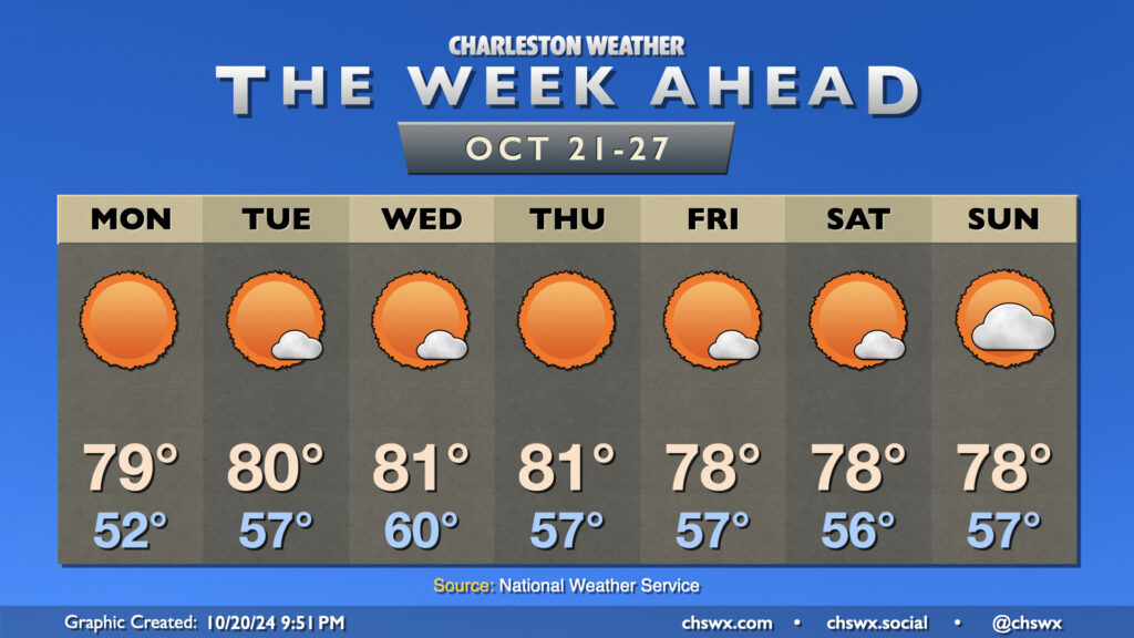
Not a whole lot to discuss this week, weather-wise. Our winning streak of quiet weather continues for next week as high pressure remains the dominant feature across the eastern US. Temperatures will generally run a little above normal each afternoon, heading into the upper 70s to low 80s each day, while clear skies at night and reasonably calm winds will help temperatures fall back toward about normal, which for this point in the year is in the mid-50s. Monday will start off a little cooler, but will rebound to near 80° in the afternoon with very few, if any, clouds to be found. A dry front brings a slightly cooler airmass to the area for the weekend, but this will only knock temperatures down a couple degrees.
Looking for rain? Not much to be found in the seven-day, as you can see. Offshore shower activity mid-week should stay there with high pressure in place on land. It may be next week before we get some showers back into the picture based on some of the longer-range models, but even then it doesn’t look like we will get much, if any. We are getting into a climatologically drier period of the year — in fact, November is typically the driest month of the year. Still, we’re running about a 2″+ surplus thanks to Debby back in August.
Finally, this most recent round of coastal flooding concludes with Monday’s midday high tide, when water levels should peak around 7.1-7.3′ in the harbor, causing some salt water flooding a couple hours on each side of the 11:47 AM high tide. From there, expect high tides to stay below flood stage for at least the rest of this week as we head into the third quarter phase on Thursday.
High pressure continues to be the main weather driver at the surface this weekend, and as an upper low departs, will build in aloft to help temperatures warm up for the weekend. Friday starts on the chilly side once again, with lows bottoming out in the low 40s away from the coast. Wind chills will be less of a factor Friday morning, but a light breeze could still make it feel a couple degrees cooler. Temperatures will warm to the upper 60s to around 70°, making for a nice Fall day across the Lowcountry.
Warm weather fans will rejoice as the aforementioned ridge of high pressure aloft begins to build in. We get Saturday off to a warmer start, with lows in the upper 40s away from the locally warmer coastline. From there, highs peak in the mid-70s for the first time in a few days with just a few passing clouds from time to time. We turn even warmer on Sunday, with temperatures in the low 50s in the morning rebounding to the mid-to-upper 70s in the afternoon, with a few clouds once again dotting an otherwise brilliantly sunny sky.
The only weather-related concern for this upcoming weekend will be the risk for minor to moderate flooding around the morning high tides. Friday morning’s high tide between 7.4-7.6′ may be commute-impacting as it takes place around 9:05am. Flooding would take place a couple hours on either side of high tide, and at this height, road closures in downtown Charleston begin to become more numerous. Even higher tides are expected Saturday and Sunday, with water levels forecast to peak solidly in moderate flood stage (7.5-8′ MLLW in Charleston Harbor). Once again, road closures are likely, though the impact may be lessened as it’ll be the weekend. The highest tides will take place around 9:58am on Saturday and 10:51am on Sunday. Keep an ear out for Coastal Flood Advisories this weekend as they will let you know when the roads are most likely to be disrupted.
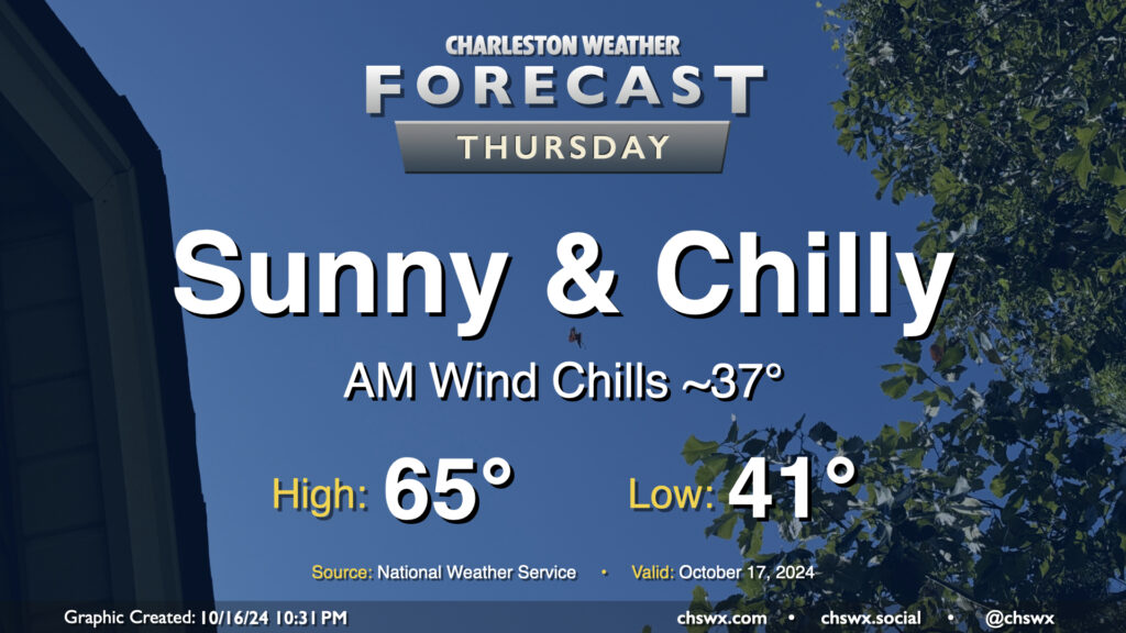
Temperatures reminiscent of November rather than mid-October continue on Thursday despite unfettered sunshine. We’ll start the day in the low 40s in the metro, with some upper 30s possible further inland. The wind chill will feel closer to the mid-to-upper 30s, so once again, layers are a good idea tomorrow morning. Temperatures head to the mid-60s in the afternoon, so keeping some sort of long sleeves around for when you’re not in sunlight is a smart play. Northerly winds will once again be breezy, generally 10-15 MPH in the afternoon with higher gusts.
We’ll also need to watch for minor coastal flooding during the Thursday morning commute. Water levels are expected to peak around 7.1-7.3′ with the 8:13 AM high tide. The more northerly component of wind will minimize coastal flood impacts a little, but we can still expect a few road closures in the more vulnerable locations of downtown Charleston. Be ready to reroute.
A reinforcing cold front will swing through overnight tonight, ushering in the coldest air so far this season. We’ll start the day in the low 50s, but gusty north winds will cause temperatures to struggle to the low 60s despite increasing sunshine as clouds from the frontal passage dissipate. This certainly qualifies for sweater weather in our neck of the woods — have the warm clothes at the ready!
Thursday morning will be the coldest of the set as the cool air continues to push into the area, though winds will diminish a little. Temperatures in much of the metro could dip into the upper 30s to around 40° — quite possibly the coldest morning since February 22, when it was 37°. The wind chill will be a factor (pun somewhat intended), and could make it feel close to freezing. A couple layers aren’t the worst idea heading out the door in the morning. Despite full sunshine, temperatures will still only recover to the mid-60s at best in the afternoon. This is well below normal for this point in the year (think upper 70s), and may flirt with record cold high temperatures as well (62° set in 1970).
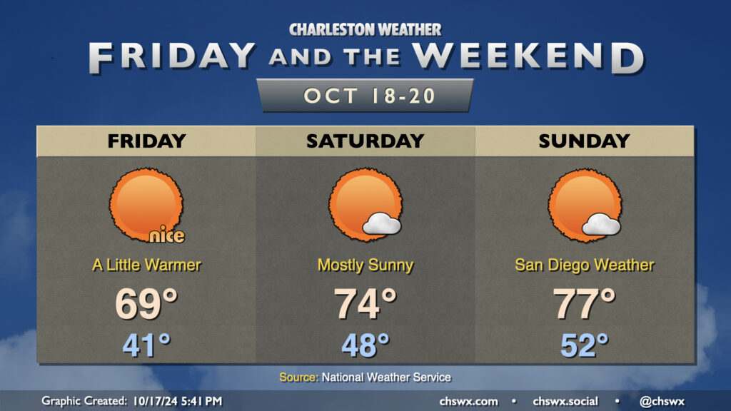
Temperatures start to bend back toward climatology on Friday, though. We’ll start the day in the mid-40s as a bit more of an onshore component to the wind develops, heading to about 70° in the afternoon under sunny skies once again. As we get into the weekend, temperatures will continue to run a bit below normal, but mid-70s will mean short sleeves are back on the menu. With plenty of sunshine, it’ll be a solid weekend of San Diego-like weather (if you know, you know).
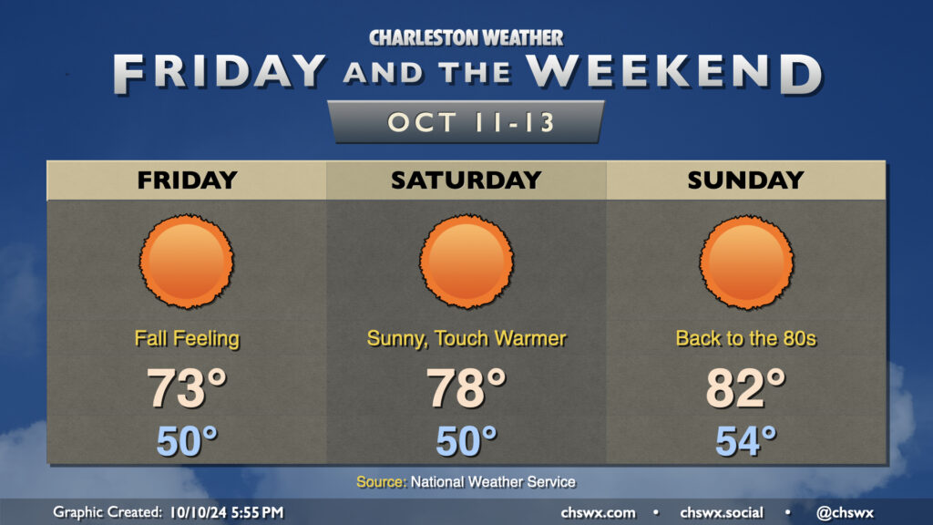
Get ready for the first low 50s of the season starting tomorrow morning! Lows are forecast to bottom out around 50° — and into the upper 40s further inland — for the first time since April 24 on Friday morning. This will yield to highs in the low 70s in the afternoon under predominantly sunny skies. The northeast breeze will still be elevated in the morning, gradually winding down as we get into the evening.
Saturday gets off to a similarly chilly start, though the airmass will begin to moderate as highs climb back into the upper 70s in the afternoon with nearly uninhibited sunshine expected. The warming trend continues Sunday, with a slightly warmer start in the mid-50s warming to highs in the low 80s in the afternoon.
The only weather-related concern of note will be the risk for some minor flooding around the afternoon high tides Friday and again on Saturday as the northeast breeze persists. However, major flooding disruptions do not appear to be in the cards.
Finally, there’s nothing in the tropics we need to be worried about. In fact, it may be a while before we get any more rain. A dry front early next week could usher in even cooler weather, well below normal for mid-October standards. Watching it…
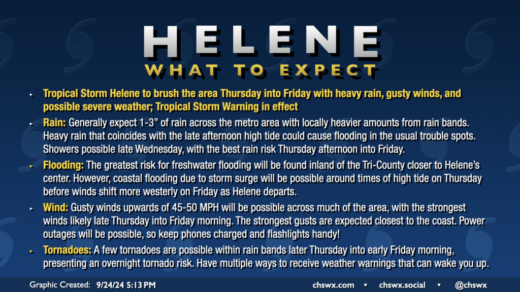
Hurricane Helene’s outer fringes will begin to affect the area on Thursday, with impacts peaking Thursday afternoon through Friday morning. Gusty winds, heavy rain, and a risk for tornadoes are the main concerns. A Tropical Storm Warning is in effect for the Lowcountry, including the entirety of the Charleston Tri-County area.
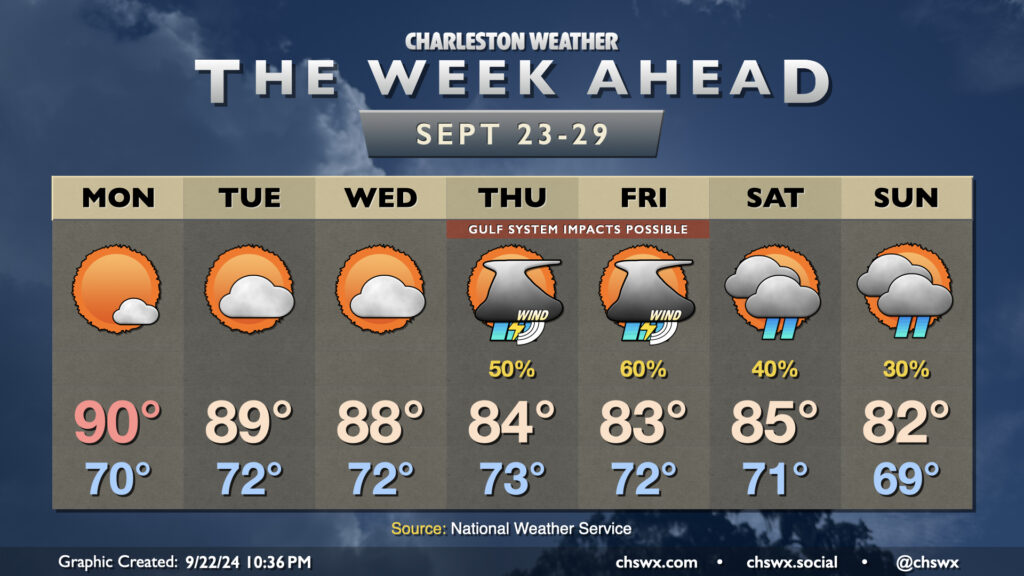
Well, it might be fall, but our local weather will continue to betray the calendar for a few more days as Atlantic high pressure to our east and ridging aloft keeps things warmer than normal as we head into the last week of September (already?). Then, things turn a little more interesting as we watch for the potential for a tropical cyclone to move northward through the Gulf of Mexico. Depending on how far east the storm develops and tracks, it’s possible we may see some impacts here at home, but it’s very tough to say exactly what that will look like just yet.