Thursday: Another hot day before turning unsettled this weekend
Heat peaks on Thursday before a cold front affects the area this weekend, bringing more widespread unsettled weather to the area starting Friday.
Read more »Heat peaks on Thursday before a cold front affects the area this weekend, bringing more widespread unsettled weather to the area starting Friday.
Read more »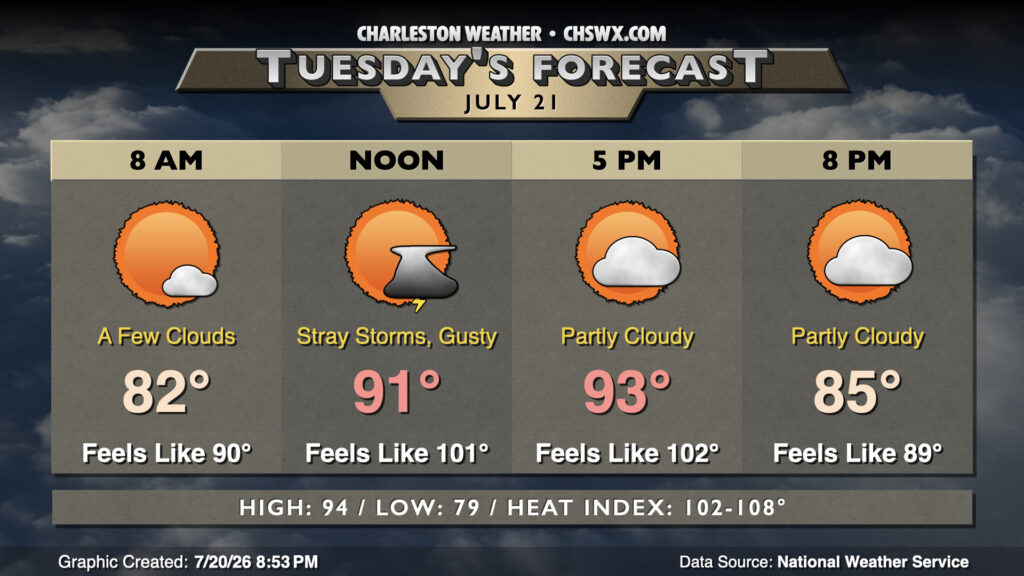
Tuesday looks similar to Monday, with temperatures warming into the low-to-mid-90s in the afternoon after another sultry start in the upper 70s to low 80s. Heat indices inland will run in the low 100s, but may push 108° as we get closer to the coast and the higher-dewpoint air. Southerly winds will continue to be breezy, with gusts pushing 30 MPH at times midday.
Read more »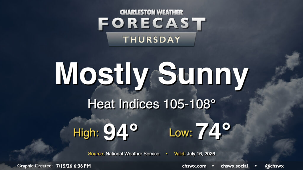
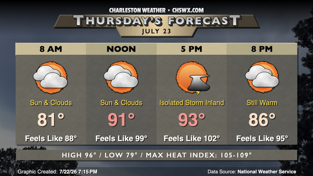
High pressure rebuilding aloft will bring more sunshine — but more heat, too. We’ll start Thursday in the mid-70s inland to upper 70s near the coast. From there, plenty of sunshine will drive highs into the mid-90s. Dewpoints will be fairly juicy — generally in the mid-to-upper 70s — and this will drive heat indices well into the mid-100s. Closer to the coast as well as in downtown, dewpoints near 80° will help drive the heat index up toward 108° for at least a brief period. Heat Advisory criteria is a heat index 108°-112° for two hours or more, and we certainly could be close in the coastal corridor. Regardless, be sure you’re taking frequent breaks in the shade with plenty of water if you’re working outside.
Read more »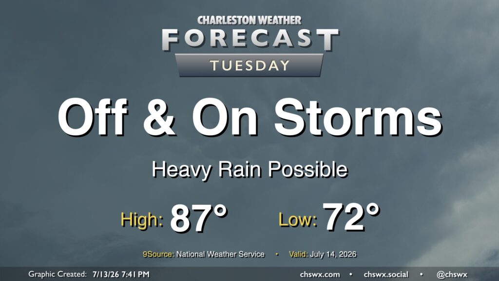
Showers and thunderstorms will feature prominently in the forecast on Tuesday as they develop around a stalled boundary lingering to the south. Periods of heavy rain will be possible, and an area or two of freshwater flooding can’t be totally ruled out. However, severe weather is unlikely, and this will largely be a beneficial rainfall event. Even better, highs should peak below 90° for the first time since June 24. So, even though there will be rain, it’ll be awfully nice to not be baking.
The main flooding concern arrives with the evening high tide; minor to moderate coastal flooding will be possible between 7-10 PM. We’ll need to monitor where the rain is carefully; any rain that coincides will cause issues downtown.
Read more »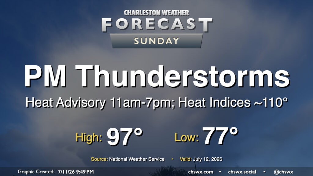
A slower frontal progression from the north will allow air temperatures to head back into the mid-to-upper 90s on Sunday, prompting another round of Heat Advisories and juicing up the atmosphere for another round of strong to potentially severe thunderstorms in the afternoon and evening.
Read more »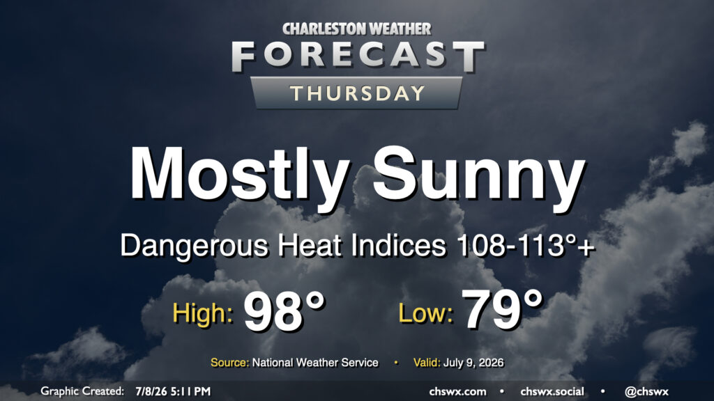
It was a stifling hot Wednesday in the Lowcountry, with highs reaching the upper 90s and heat indices peaking between 113-116° in parts of the metro area. Another round of high heat is in store for Thursday, as temperatures once again return to the upper 90s. Dewpoints near the coast and behind the seabreeze should surge well into the mid-to-upper 70s once again, sending heat indices between 108-113° (with locally higher readings possible) in the Highway 17 corridor. This has prompted another Extreme Heat Warning for Charleston County as well as the southern portion of Berkeley County that includes Hanahan and Daniel Island. Elsewhere, a Heat Advisory will be in effect for heat indices around 108-110°. Model guidance still suggests a few showers and thunderstorms will fire off along and ahead of the seabreeze, which will help cool some of us off. Coastward storm motions moving against the inland-moving seabreeze could cause some back-building of thunderstorms with some locally heavy rain. The strongest storms could produce damaging wind gusts, and a warning or two can’t be totally ruled out as a result.
Read more »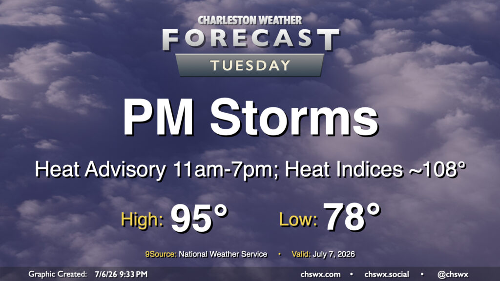
The heat wave continues Tuesday with another hot and humid day on tap, followed by a scattering of afternoon thunderstorms. We’ll start in the upper 70s inland to low 80s near the coast and downtown, warming to the mid-90s in the afternoon. Dewpoints in the mid-70s will drive heat indices toward 108-110°. Another Heat Advisory will be in effect for Charleston and Berkeley counties as a result. Further inland toward Dorchester, dewpoints should be ever so slightly low enough to stay out of Heat Advisory criteria, but it’s still going to be plenty hot.
From there, a few thunderstorms should fire along and ahead of the seabreeze. Storm motions should be a little more coastward, so keep an eye out at the beaches for possible thunderstorms. A stray severe storm is not out of the question, with damaging wind gusts and hail to the size of quarters possible.
Read more »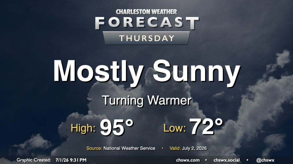
High pressure continues to dominate the weather pattern, which keeps things toasty and rain-free for Thursday. Fortunately, drier air will still be in place for one more day, which will allow for lows to drop to the low 70s in the morning. From there, we’ll warm to the mid-90s in the afternoon. Dewpoints will mix down to the mid-60s, keeping heat indices within a degree or two of the air temperature. It’ll still be plenty hot, but a drier heat will be appreciated.
Read more »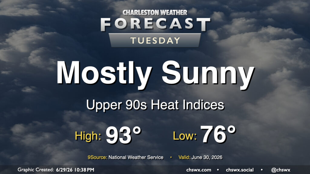
High pressure wedging southward into the Lowcountry and the resulting northeasterly flow will take a slight edge off the heat for Tuesday after another day in the mid-90s on Monday. It’ll still be a steamy start, though, and the low of 78° will get awfully close to the record warm low temperature of 79° set in 2024. We’ll warm into the low 90s in the afternoon, but dewpoints running in the low to mid-70s will drive the heat index into the upper 90s (standing in contrast to the mid-100s we’ve felt the past few days). High pressure ridging in aloft will put a lid on thunderstorm activity, though some of the convection-allowing models still try to squeeze out a few showers in the afternoon. Rain is highly unlikely, though, so don’t count on it.
Read more »
Another quiet day is on tap for Thursday with high pressure in control. Lows bottom out in the low 70s, warming to around 90° in the afternoon. Dry air (for this time of year, anyway) will hang on for one more day, though it will be a bit more humid than it was on Wednesday. High pressure and warm air aloft should keep a lid on thunderstorms for one more day as well.
Read more »