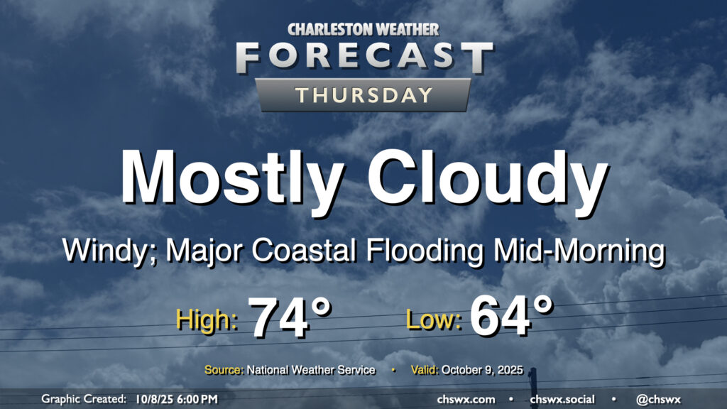
A cold front will pass through overnight, bringing with it a chance for showers and maybe even some thunder as it moves by. Behind that front will be a significant airmass change as high pressure builds southwestward into the area. We’ll wake up to lows in the mid-60s, with temperatures climbing just to the mid-70s under mostly cloudy skies. It’s going to be quite breezy, with northeasterly winds gusting 30-35 MPH at times, especially near the coast.
The strong northeasterly winds will drive water levels in the harbor quite high on top of already high astronomical tides, especially during the day on Thursday (and for the next several days). High tide will peak around 10:06 AM around 8-8.2′ MLLW, which is comfortably in the major flooding threshold. A Coastal Flood Watch is in effect and will likely be upgraded to a warning if trends continue overnight. Be ready for numerous road closures in downtown Charleston as well as salt water impingement onto roads on James and Johns Islands as well as Daniel Island. Moderate coastal flooding is expected with the evening high tide as well, with water levels peaking around 7.5-7.7 MLLW between 9 PM and midnight. This should be high enough for another round of road closures downtown, so be mindful if your travels take you there Thursday night.
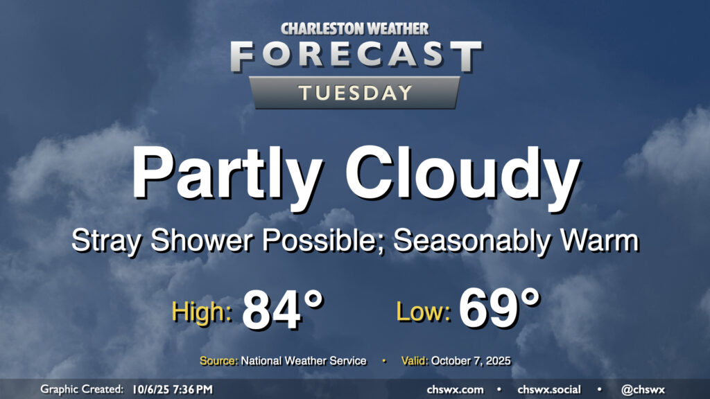
We stay warm on Tuesday with another day of high pressure at the surface and aloft driving temperatures above normal across the area. We’ll start the day near 70°, warming to the mid-80s in the afternoon under partly cloudy to mostly sunny skies. A few showers appear possible near the coast during the morning and early afternoon hours, but otherwise, many of us should get a rain-free day in.
We will need to continue to monitor the risk for coastal flooding around times of high tide, especially during the morning, with minor to moderate coastal flooding likely between 6-11 AM. (High tide peaks around 8:23 AM.) When we get into moderate flood stage, we start to run into more widespread road closures downtown, and given the timing, commute impacts appear likely. Allow extra time to reach your destination if downtown is where you’re headed in the morning. Another round of minor coastal flooding will be possible generally between 7-11 PM, which may yet close a few vulnerable roads but should not get as high as the morning high tide.
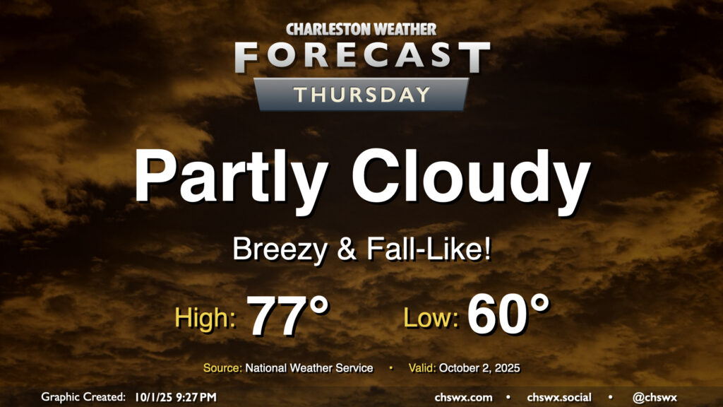
Thursday will give us a really nice taste of fall as cool high pressure wedges southward into the area. We’ll start the day with temperatures around 60°, warming to just the mid-70s under partly cloudy to mostly sunny skies. The northeasterly breeze will still be somewhat elevated, which may contribute to some minor tidal flooding around the 4:45 PM high tide. Otherwise, it’ll be an enjoyable day to get outside and touch some grass.
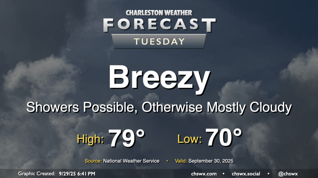
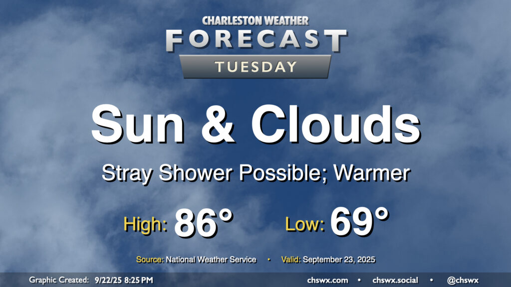
The pressure gradient between high pressure to the north and Imelda to the southeast will be tightening on Tuesday, and we should have a fairly breezy and seasonably cool day once again thanks to those northeast winds as well as cloud cover and a few lingering showers. Temperatures start around 70°, but should only warm to the upper 70s to maybe 80° depending on breaks in the clouds. The decaying coastal front will still be able to contribute to a few showers, but we should see shower chances diminish as we get through Tuesday and Imelda pulls further and further offshore.
There’s a chance that we could see some minor tidal flooding Tuesday afternoon courtesy of elevated water levels due to the onshore, northeasterly flow. The better chances for coastal flooding will begin Wednesday, though, and may be with us for a little bit as we head toward a full moon next week.
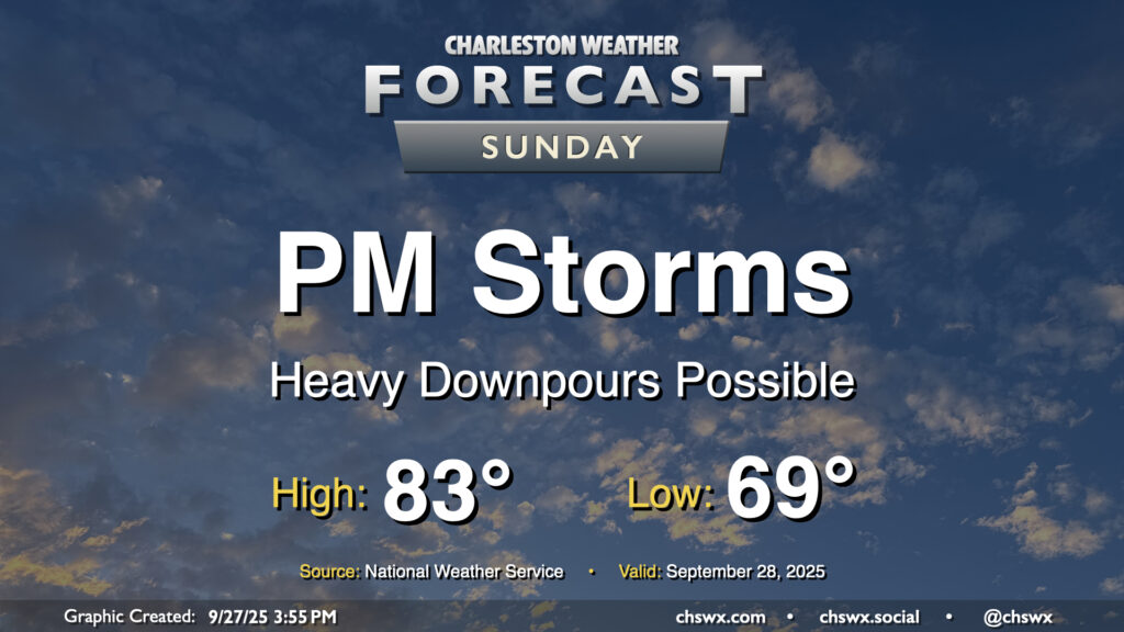
Sunday should feature another round of showers and storms, most likely in the afternoon, as a front in the vicinity starts to retrograde westward a bit courtesy of TD Nine (which should soon get the name Imelda; it hasn’t yet as of this writing). Temperatures will be near if not slightly cooler than normal once again Sunday with the prevalence of cloud cover (especially in the afternoon) and the slightly cooler and drier airmass behind the front. We start the day in the upper 60s in the metro to the low 70s at the coast, warming to the low to mid-80s in the afternoon before scattered showers and storms kick back up. From there, we will see several more days of inclement weather courtesy of the approaching tropical cyclone.
I’ll have a more detailed post specific to the tropics a little later this evening once we have the new track and intensity forecast in hand.
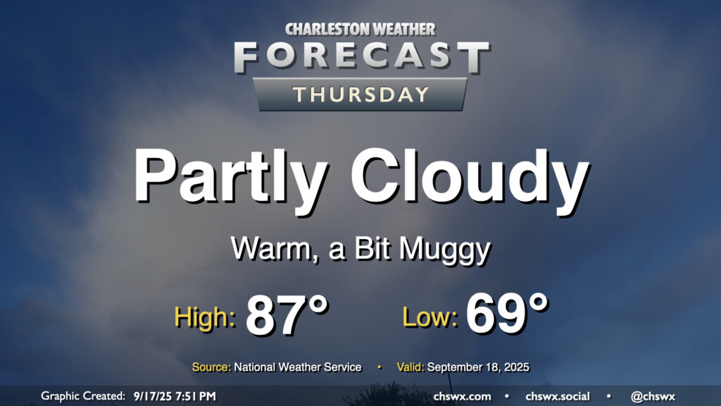
After hitting 91° on Wednesday, we look to take another trip to the 90s on Thursday as ridging aloft combines with Atlantic high pressure to keep us well on the warm side of normal for another day. Temperatures start in the low to mid-70s, well above normal for this point in the year, warming to the 90s in the afternoon with heat indices making it feel more like the mid-90s. We could see a stray shower or thunderstorm in the afternoon and evening along and ahead of the seabreeze, but most of us should stay dry.
A warming trend begins Tuesday as high pressure to the north continues to weaken and winds turn more onshore, ushering in a much more summer-like feel over the next few days. Temperatures Tuesday start in the upper 60s to around 70°, warming to the mid-80s in the afternoon with a mix of sun and clouds. Factor in the upper 60s-lower 70s dewpoints and it’ll feel more like 90°. Like we saw on Monday, a few afternoon showers are possible, though the weakening high also will portend a weakening coastal trough, which should keep the risk for showers relatively low.
Another warm day is ahead for Thursday as high pressure generally remains in control with winds coming a bit more out of the west and southwest. Temperatures Thursday start much warmer than they did on Wednesday, with lows in the upper 60s to around 70° expected. We’ll warm to the mid-to-upper 80s in the afternoon under generally partly cloudy skies. A stray shower or storm is possible well inland, but the vast, vast majority of us will stay rain-free.
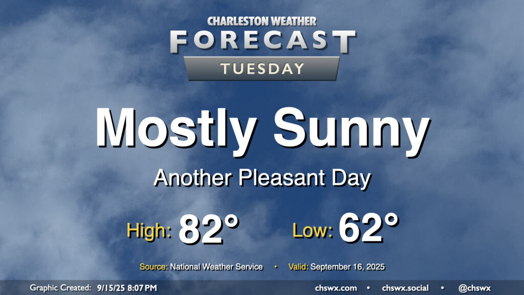
There’s not too much to write home about weather-wise for Tuesday other than it will be a really nice mid-September day across the Lowcountry. Below-normal temperatures continue, with lows in the low 60s warming to the low 80s in the afternoon under mostly sunny skies. Dewpoints mix down to the mid-50s in the afternoon, making the warmth comfortable. Plus, water levels will fall short of flood stage Tuesday as we get further away from the full moon and the recent perigee, so there are no coastal flooding concerns for the rest of the week, either.
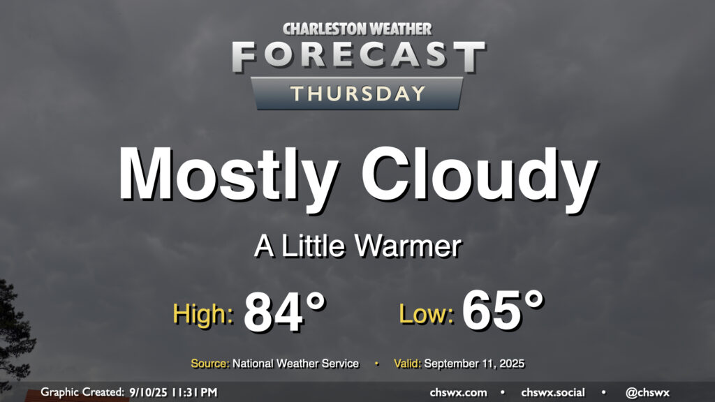
Thursday will run a bit on the cloudy side, but we’ll still see some peeks of sun at times to allow temperatures to warm from the mid-60s in the morning to the mid-80s in the afternoon. Northeasterly winds persist, keeping dewpoints relatively low and the air comfortably warm as a result. We will continue to contend with some salt water flooding around the midday high tide, which could close a few roads for those of us headed for an early lunch downtown.