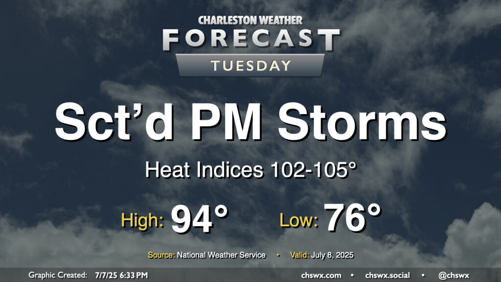
It’ll be another hot and humid July day across the Lowcountry on Tuesday as high pressure at the surface and aloft remain the predominant weather features, at least for one more day. The morning starts in the mid-70s inland to near 80° at the coast and downtown, warming to the mid-90s once again in the afternoon. Heat indices should rise in the 102-105° range, especially in the immediate wake of the seabreeze thanks to the dewpoint surge that typically accompanies it. We should see showers and thunderstorms fire along and ahead of the seabreeze by afternoon. Storms that fire could dump a good bit of rain in some spots in a short period of time thanks to the tropical airmass left behind by Chantal, so we will need to monitor for the potential for minor flooding in poor drainage areas. A stronger storm or two can never be ruled out this time of year, either, with gusty winds the main concern.
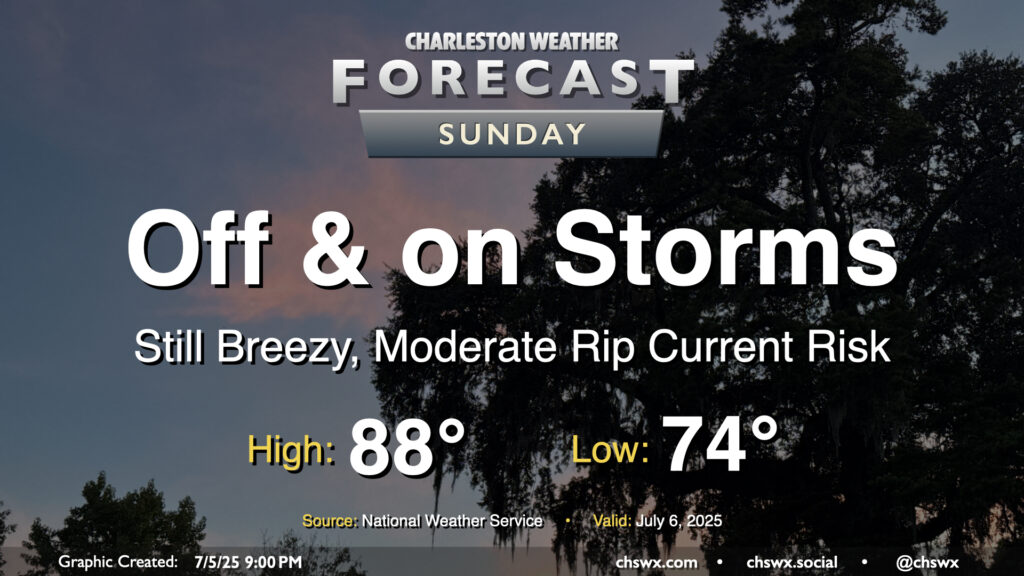
Tropical Storm Chantal will make landfall overnight somewhere between Georgetown and Myrtle Beach, keeping the risk for some showers around overnight into Sunday. We should see an uptick in shower and thunderstorm activity as the heating of the day helps to wring out some wrap-around moisture on the southwest side of Chantal’s circulation. Overall, though, this storm hasn’t been a major rainmaker for the area, and that shouldn’t change much on Sunday with the scattered nature of the individual showers and thunderstorms. Severe weather is not expected as we sit within the weaker side of Chantal’s circulation, but the risk for rip currents will continue and we should still have some breezy conditions at the beaches and on the bridges. Temperatures will start in the mid-70s again, but highs should stay below 90° for one more day with the clouds and rain in the area (though we should see a decent amount of sun between showers, too).
By the way, our 90° streak ended today at 21 days — the high at the airport topped out around 85°. Don’t worry, though — we’ll kick off a new streak starting Monday, and temperatures for the upcoming work week will certainly have that July feel to them, complete with Advisory-level heat indices.
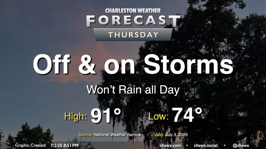
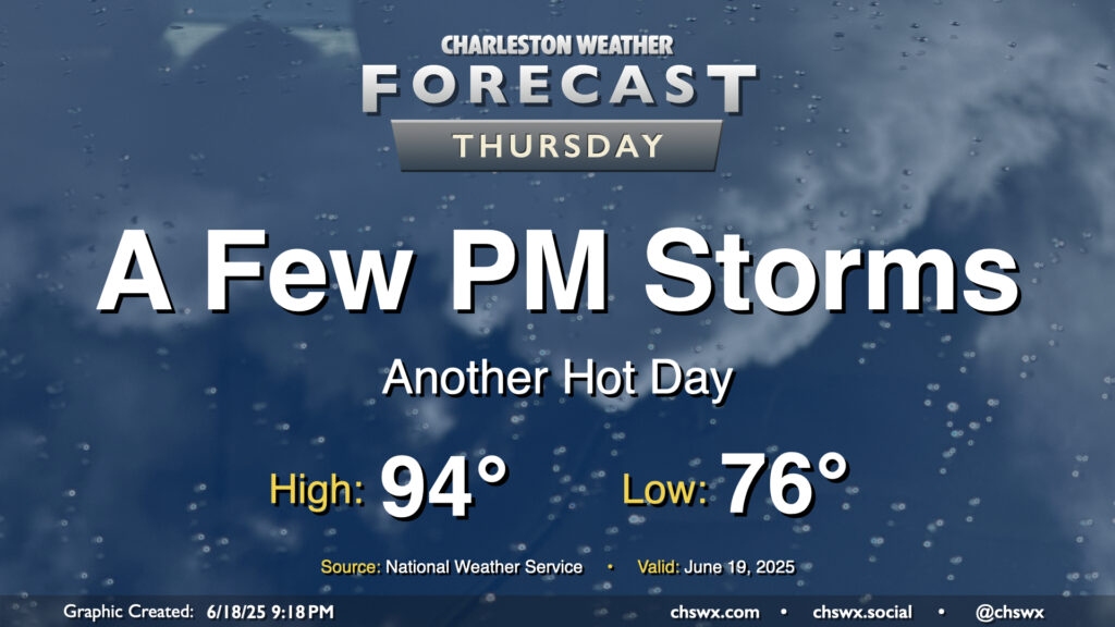
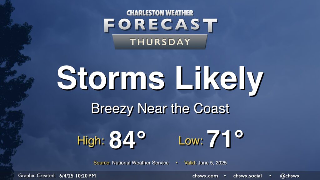
While storms so far on Wednesday were more off than on, more chances for rain arrive on Thursday with the heating of the day and a stalling front that will be in the neighborhood. Temperatures start in the mid-70s, warming to the low 90s in the afternoon — right on the line for what to expect from early July. Showers and thunderstorms will be capable of heavy rain and frequent lightning, and an isolated severe storm can never be ruled out this time of year where boundaries collide.
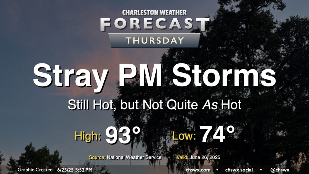
The high heat of the past couple days — we hit 98° again on Wednesday, just one degree off the record high — will let up on Thursday as high pressure aloft continues to weaken. Don’t misunderstand: it’ll still be plenty hot, but not to the Advisory-level thresholds we’ve hit recently. After a start in the mid-70s, likely in the wake of thunderstorms that are expected late tonight into early Thursday morning, temperatures in the afternoon warm to the low 90s. Dewpoints will mix down to around 70°, so heat indices should stay relatively tame, with a brief spike into the upper 90s possible as the seabreeze pushes inland. A few showers and thunderstorms could pop on the seabreeze, as is often the case this time of year, but nothing out-of-bounds is expected.
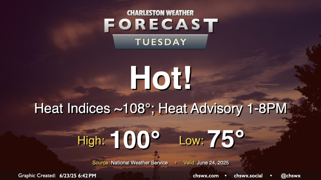
A very hot Tuesday is in the offing as high pressure at the surface and aloft remain in place, allowing temperatures to head into the upper 90s to around 100° across the area away from the coast, where temperatures should peak in the low to mid-90s. Regardless of where you are, heat indices should peak around 108-109° as well, prompting a Heat Advisory for the Tri-County area — the first of 2025 — that’ll go from 1-8 PM. If you are working outdoors during that period in particular, be sure you’re getting plenty of fluids and taking frequent breaks in the shade or, preferably, an air-conditioned environment. Be very vigilant about any children or pets in the car, too — it doesn’t take very long at all for temperatures to become very dangerous in cars, and we don’t want any hot car deaths. Look before you lock!
If a high of 100° verifies at the airport, it would be the first time since May 29, 2019 (the Before Times!) that the temperature at the airport reached 100° or higher. Triple-digit heat isn’t expected east of 17, including in downtown Charleston and at the beaches, but the closer proximity to higher-dewpoint maritime air will still send heat indices into the danger zone despite the lower air temperatures.
Looking for thunderstorms to cool you off? I wouldn’t count on it, though a stray storm can never be fully ruled out this time of year.
More heat and humidity are on tap for Thursday, but with a slightly better chance of storms in the afternoon especially as a front gets closer to the area. We’ll start the day in the mid-70s once again, warming back to the mid-90s in the afternoon. We’ll be keeping an eye on a line of thunderstorms to our northwest, which could help induce some stronger storms in the metro later in the afternoon through the evening hours. Damaging wind gusts would be the primary concern in the strongest storms, though the risk for severe weather is generally low (but not zero) across the area.
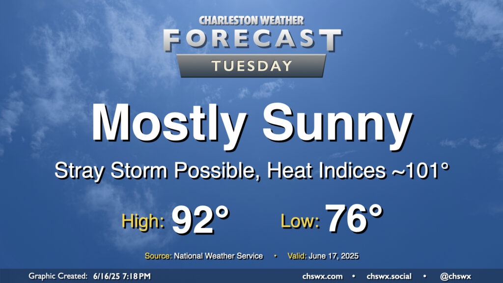
High pressure will continue to build in aloft, sending temperatures upward and storm chances downward. Tuesday will be another rather warm day, with lows in the mid-70s to start the day warming to the low 90s in the afternoon. Mix in dewpoints running in the low 70s, and that’ll yield heat indices right around the 100-101° mark during the height of the afternoon. Heat indices could even briefly spike in the immediate wake of the seabreeze as dewpoints surge before temperatures start to fall.
A storm or two will be possible along and ahead of the seabreeze, but with the capped atmosphere, it’s going to be tough to get much, if anything, to break through, much less sustain itself. Still, though, you can never completely rule it out this time of year.
After a quiet start to the day, another round of afternoon showers and thunderstorms are expected to develop and move across parts of the Tri-County on Thursday as we remain in an unsettled pattern. Alas, we will keep this going into the weekend, too.
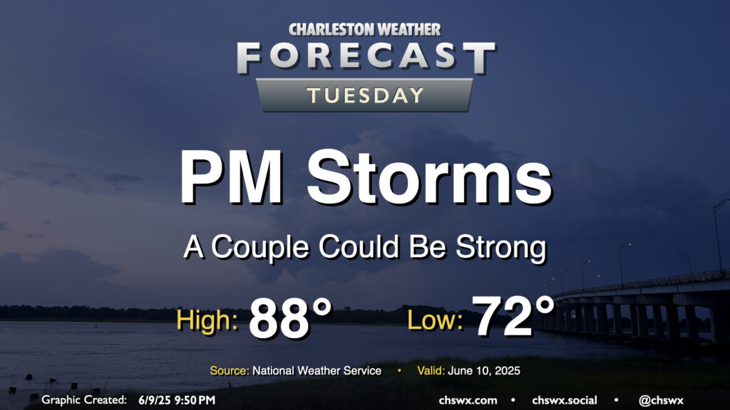
Showers and storms, a few of which could be on the strong side, will be possible again on Tuesday, particularly in the afternoon, as low pressure aloft remains in place and the heating of the day kicks in. The warm and muggy airmass stays in place, with lows in the low 70s warming to the upper 80s in the afternoon before storms develop. Guidance suggests showers and storms develop in the 2-3 PM timeframe, and there will be the risk for a storm or two to become severe once again with damaging winds the main threat. The risk for severe weather is a little lower Tuesday, but will still need to be monitored especially after a rough day for Summerville.
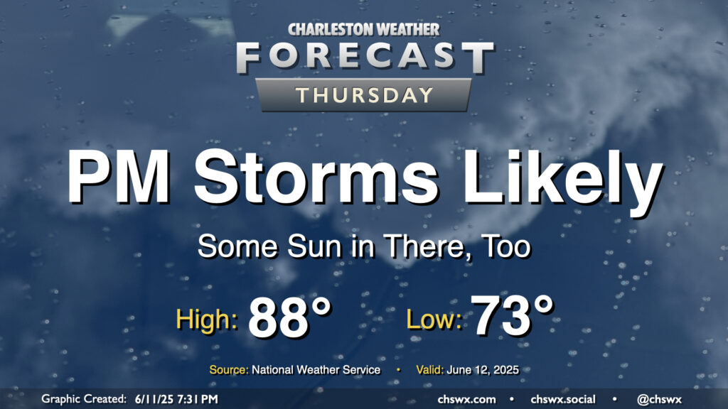
Thunderstorms remain likely, especially in the afternoon, as low pressure lifts north and away from the area throughout the day. A warm and humid airmass remains in place, and this will get us off to a balmy start in the low 70s. Scattered to numerous showers and thunderstorms should redevelop by afternoon, keeping highs suppressed to the mid-80s. Rain could still be heavy at times, with spots potentially reaching another inch of rain or so before it’s over. Not everyone will see that kind of rain, though.
Breezy conditions remain possible especially at the coast and over the waters, so it’ll be another day where boating and beaching will be generally unadvisable. The good news, though, is that with the low pushing inland, the risk for any sort of tropical development — low as the risk was this entire time — has ended. (Take the wins where you get them.)