Tropical Storm Danny to make landfall in the next couple hours
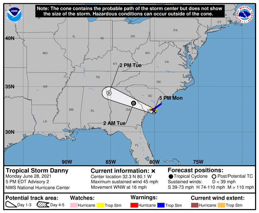
Tropical Storm Danny, which was named in a tropical cyclone update a little after 3PM after radar and recon data indicated it had strengthened, is on course to make landfall somewhere between Hilton Head and Edisto over the next couple hours.
At 5PM, it had maximum sustained winds of 45 MPH — a little up from the previous advisory. It’s still moving WNW at 16 MPH, and the NHC center fix had it 35 miles east of Beaufort and 35 miles SSW of Charleston. A tropical storm warning remains in effect for the Charleston County coastline, where gusts to tropical storm force remain possible through this evening.
On and off rain squalls have been pelting much of the Charleston area over the past few hours, with winds consistently gusting 20-30 MPH at the airport. It is worth noting, though, that with much of the heavy thunderstorm activity remaining displaced well to the west of the center, rainfall estimates have been rather tame across much of the area. The main exception is a small swath from Kiawah to Edisto, which received upwards of 1.5″ of rain after a heavy squall came through then. There have been no reports of flooding in the Charleston metro area, and so far only one report of a downed tree.
Model data and radar trends indicate that we are through the worst of it here in Charleston. The eastern semicircle of the storm is much drier, owing to the persistent wind shear that has been blowing the thunderstorms out to the west. Scattered showers continue across inland locations, but we are seeing a marked decrease in rainfall rates and coverage over the last couple hours. Still, tropical storm-force gusts will be possible especially from Charleston Harbor southward to Folly, Kiawah, Seabrook, and Edisto Islands through tonight, so we cannot totally rule out isolated power outages or additional downed trees.
Next intermediate advisory will be at 8PM.