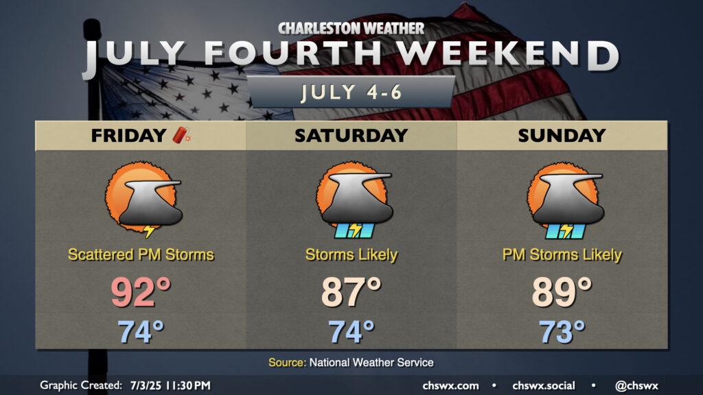
The weather for the Fourth of July weekend looks a bit on the unsettled side as low pressure — perhaps tropical in nature — spins up offshore and increases the risk for rain near the coast.
Independence Day itself looks okay with a bit of drier air working into the area in the wake of a stalling front. There’s still enough juice for a few thunderstorms along and ahead of the seabreeze in the afternoon, so be sure you have indoor alternatives to your outdoor plans just in case thunderstorms threaten. Temperatures start in the mid-70s, warming to the low 90s in the afternoon. Heat indices will run in the mid-90s to around 100° in the afternoon, particularly in the immediate wake of the seabreeze, so be wary of the heat especially if you are more vulnerable to it.
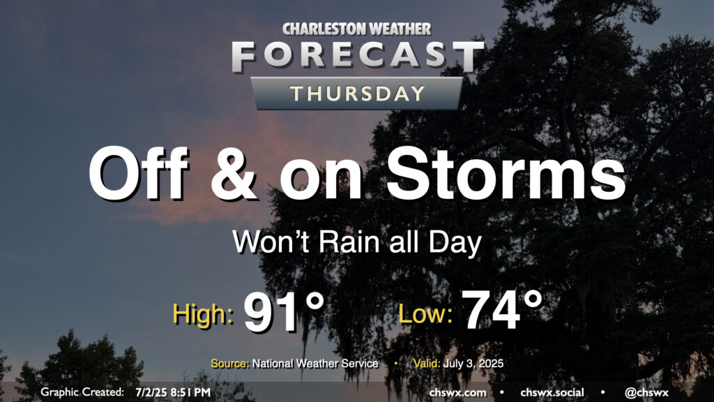
While storms so far on Wednesday were more off than on, more chances for rain arrive on Thursday with the heating of the day and a stalling front that will be in the neighborhood. Temperatures start in the mid-70s, warming to the low 90s in the afternoon — right on the line for what to expect from early July. Showers and thunderstorms will be capable of heavy rain and frequent lightning, and an isolated severe storm can never be ruled out this time of year where boundaries collide.
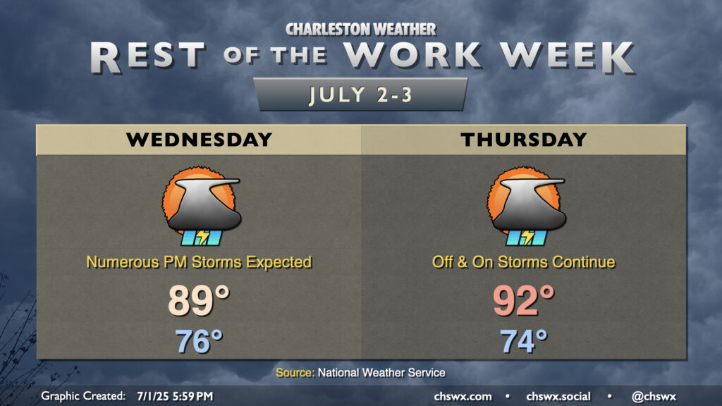
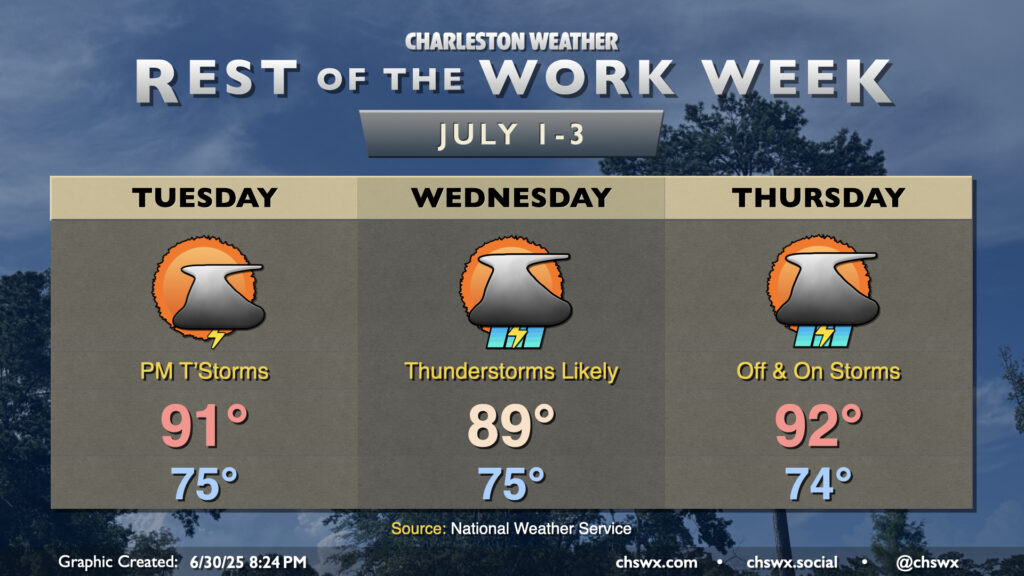
A cold front will draw nearer to the Lowcountry on Wednesday before stalling out, which will help kick up the risk for thunderstorms especially during the afternoon and evening hours. It won’t rain all day, but many of us should measure some rainfall as storms push across the area from west to east through late night. Temperatures in the mid-70s will warm to the upper 80s to around 90°. There’s a chance our 18-day streak of 90°+ highs will come to an end thanks to the proliferation of cloud cover, showers, and thunderstorms on Wednesday, but we will see. Regardless, expect a steamy and eventually stormy day across the metro; be ready for rain to cause some slowdowns.
Thursday is looking a little better, though some storms could linger midday. But drier air will be moving in, and we should see improving conditions by evening. It’ll be another warm day, with highs returning to the 90s in the afternoon after another mid-70s start.
The rest of the work week will turn increasingly stormy as a cold front encroaches on the area by midweek. A trough aloft will help drive the front close to the area — but not quite through — and contribute to an influx in lift and moisture that’ll bring us scattered to numerous thunderstorms, particularly on Wednesday.
We will not get to declare independence from hot weather this July 4th, that’s for sure: After a balmy start in the upper 70s, temperatures will once again head into the mid-90s in the afternoon with heat indices running between 105-110°. Once again, you’re going to want to make sure you’re getting plenty of water and getting in the shade at times. Headed to the beach? Definitely deploy the sunscreen with the UV index forecast to be at 11, in the “Extreme” category.
As we get further into the afternoon and the seabreeze begins to move inland, we’ll see showers and thunderstorms begin to fire in a reasonably unstable environment. A storm or two could be on the strong to even severe side with gusty winds the main concern. Regardless of severity, the lightning a thunderstorm produces makes them all dangerous. This is especially important on a big outdoors day like the Fourth. Remember: When thunder roars, go indoors!
Finally, there will be a risk for minor coastal flooding with high tide around 9:53 PM. This tide has already caused Folly Beach to cancel their fireworks, unfortunately, and may be problematic for other beach displays as well. Be ready to avoid flooded roadways an hour or two around high tide.
The weather story of this Fourth of July holiday looks to be the first big heat episode of the season across the Lowcountry. After highs in the low 90s on Saturday, air temperatures should top out in the mid-90s on Sunday, with heat indices running above 105° in the afternoon thanks to dewpoints in the low 70s. There will be a chance for an isolated shower or thunderstorm or two on the inland-advancing seabreeze in the afternoon, but the vast majority of us will stay rain-free — and hot.
The weekend forecast basically screams “first weekend of July in Charleston.” Morning lows bottom out in the mid-70s, while highs reach the mid-90s each afternoon with a few showers and storms possible along and ahead of the seabreeze. Humidity will be on the increase throughout the weekend. Heat indices on Saturday top out around 100-101°. On Sunday, the dewpoints head into the mid-70s and sends the heat index to around 106° in the afternoon. By virtue of it being July 2nd, there will not be a heat advisory as the criteria heads up to 110° on July 1, but anything past 105° is dangerous heat, and you should take the appropriate precautions.
The only potential fly in the ointment could arrive late Saturday/early Sunday as a thunderstorm complex rounding a ridge of high pressure approaches the area. It should be weakening, but a couple models suggest that it could hang on to bring some overnight/early morning rain. These are hard to pin down beyond a day or so, so stay tuned to forecast updates. For now, though, the going forecast for isolated PM thunderstorms looks solid.
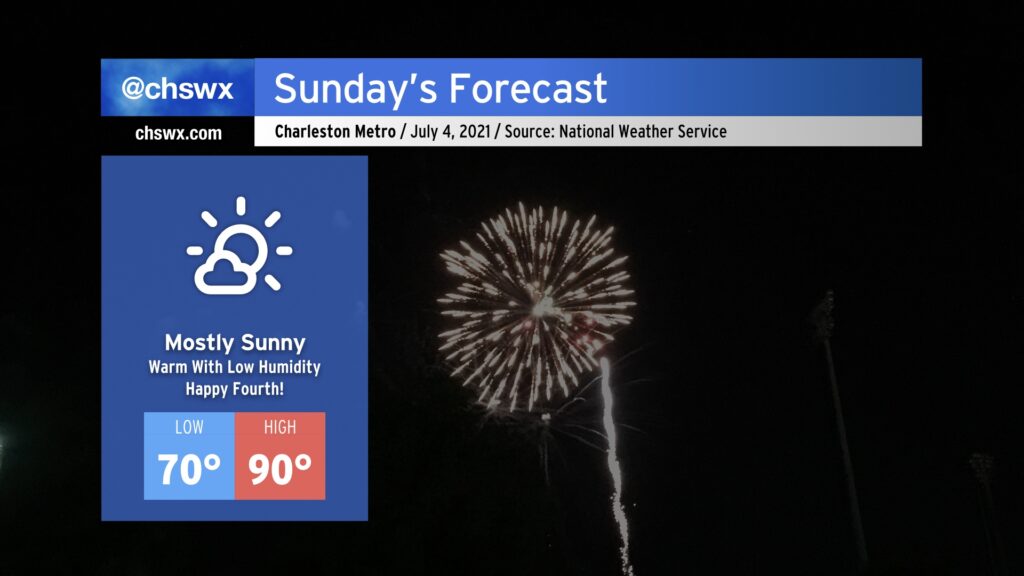
This is going to be one of the better Independence Days for weather in the Lowcountry thanks to an exceedingly rare cold front that came through this morning. Tomorrow will be warm, for sure — highs topping out around 90° away from the beaches — but the humidity (or lack thereof) will be the real story. NWS forecast dewpoints are in the low to mid-60s, which is almost unheard of around here in July. Drier air throughout the atmosphere will keep cloud cover to a minimum, making for a fantastic outdoors day across the Lowcountry. Don’t forget the sunscreen and be safe going to the beach!