Solid weather day for the Fourth as we continue to watch Elsa
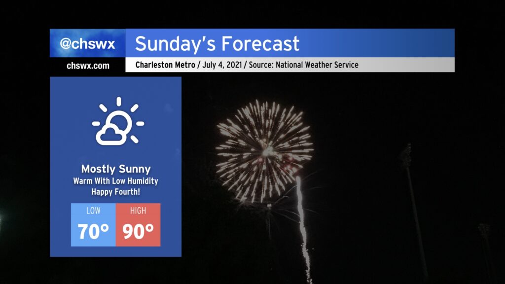
This is going to be one of the better Independence Days for weather in the Lowcountry thanks to an exceedingly rare cold front that came through this morning. Tomorrow will be warm, for sure — highs topping out around 90° away from the beaches — but the humidity (or lack thereof) will be the real story. NWS forecast dewpoints are in the low to mid-60s, which is almost unheard of around here in July. Drier air throughout the atmosphere will keep cloud cover to a minimum, making for a fantastic outdoors day across the Lowcountry. Don’t forget the sunscreen and be safe going to the beach!
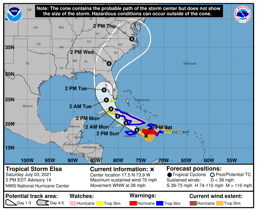
The latest on Elsa: Weaker, ultimate destination still very much in flux
I’m beginning to understand how those of you parents of young children out there felt when Frozen came out: I’m already tired of hearing about Elsa, and there’s not really much of an end in sight to that through the middle of next week.
As of 5PM, Elsa’s center was located just south of Haiti, moving WNW at 28 MPH. NHC expects the storm to slow its forward speed over the next couple days, with a turn to the northwest expected by tomorrow as it rounds high pressure in the Atlantic. Notably for the continental U.S., this advisory hoists a Tropical Storm Watch for the Florida Keys. Expect these watches to extend northward over the next couple days.
Elsa’s gotten weaker today thanks to the wind shear endemic to this part of the Caribbean, especially early in the season. It has struggled to stay organized, and as a result, it was downgraded back to a Tropical Storm earlier today. It remains a strong tropical storm, though, with max sustained winds of 70 MPH. It’s not out of the realm of possibility that it briefly regains hurricane status, especially if it can stay over water a little longer. However, the wind shear remains rather strong — certainly, the odds are against Elsa strengthening much more.
As for potential Lowcountry impacts, it’s still a really tough call. The NHC track continues to keep us within the extended forecast cone, bringing the center roughly up I-95 Wednesday. With that in mind, though, analyzing the guidance continues to be about as clear as mud. The GFS is faster and further west, and the ECMWF is slower and stays offshore (though it is worth noting that its ensemble has come significantly further west in the last few runs to better match the GFS, owing to a little better agreement on the strength of the Bermuda high). Thus, it remains very difficult to determine exact impacts and timing at this point. The best I’ve got right now is that we could see some gusty rain Wednesday and perhaps into Thursday, depending on the forward speed and position of the storm. After we get through the weekend, the details on impacts will become a little more clear. For now, enjoy a beautiful Fourth of July. I’ll have another Elsa blog update tomorrow.
Follow my Charleston Weather updates on Mastodon, Bluesky, Instagram, Facebook, or directly in a feed reader. Do you like what you see here? Please consider supporting my independent, hype-averse weather journalism and become a supporter on Patreon for a broader look at all things #chswx!