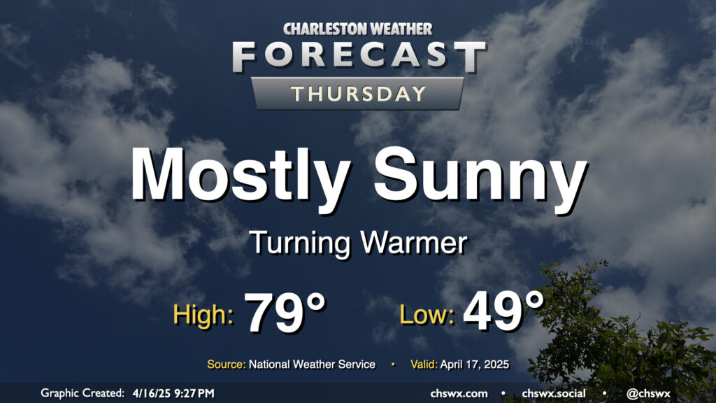
Above-normal temperatures return to the Lowcountry on Thursday as high pressure at the surface begins to head eastward. We’ll start the day in the upper 40s to around 50°, warming to near 80° in the afternoon under mostly sunny skies. I hope you get a chance to get out and about at some point because it should be another nice day!
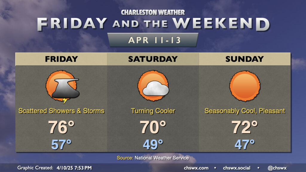
Unsettled weather makes a brief return to the area overnight into Friday as a cold front works its way toward the coast. We’ll start the day on the mild — and perhaps the wet — side as temperatures bottom out just to around the mid-to-upper 50s. We’ll warm to the mid-70s in the afternoon with scattered showers and thunderstorms continuing to affect the area. Severe weather looks highly unlikely at this stage with meager instability, thankfully. Showers and thunderstorms will end by evening as the front moves by, setting the stage for a cool but quiet weekend.
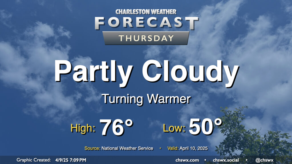
High pressure to our north, which has kept a cooler onshore flow in place that limited highs to the low 70s today, will slip offshore for Thursday, and we turn a bit warmer as a result. Expect to start Thursday right around 50°, just a touch below April 10 normals, warming to the mid-70s in the afternoon under partly cloudy skies. Should be a pleasant springtime day, all in all, especially if you like it a little warmer.
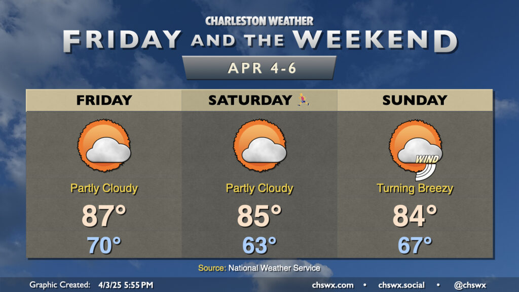
It will be a very warm Bridge Run weekend as deep-layered high pressure atop the Southeast, in a configuration more reminiscent of summer, hangs around for a few more days. We’re working on a record warm low temperature for Thursday — the low so far of 70° would blow past the previous record of 67° set in 2012 — with maybe a couple more to fall before the weekend is out.
Lows on Friday should only bottom out around 70°, which would tie the record warm low temperature last set in 1970. Highs would then soar to the upper 80s in the afternoon before the seabreeze moves through and cuts temperatures down a bit. Partly cloudy skies will be the general rule, while we stay breezy during the day owing to the pressure gradient between high pressure to the east and the stalled storm system to the west.
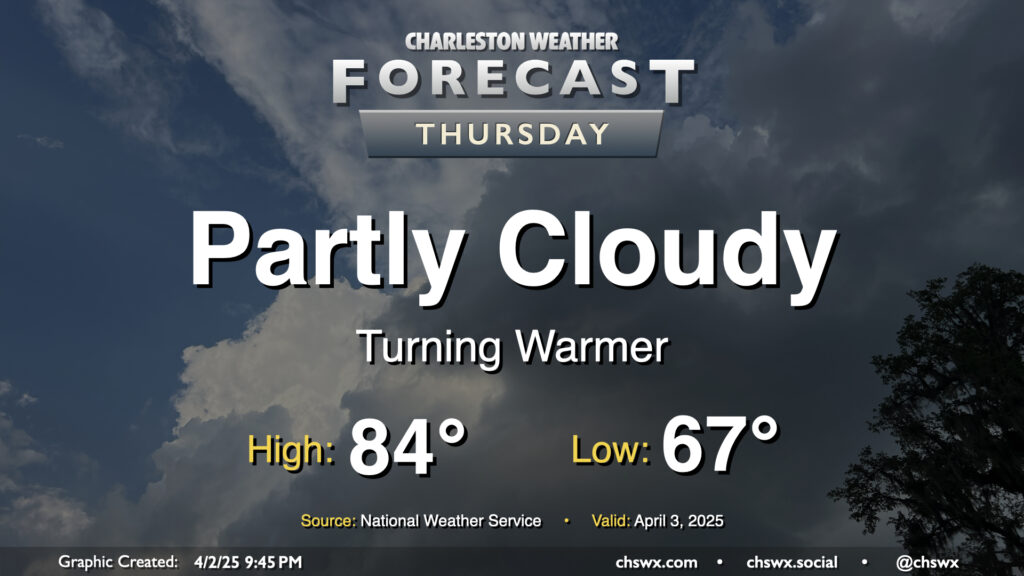
Atlantic high pressure at the surface and aloft will bring on progressively warmer weather as we hit Thursday and the rest of the Bridge Run weekend. We may set some record warm low temperatures during this stretch, starting with Thursday’s forecast low of 67°, which would tie the record warm low set in 2012. It’ll be a partly cloudy day, and the increasing influence of high pressure will keep any shower activity at bay (unlike what a few of us saw on Wednesday as a warm front lifted north). Temperatures will head to the mid-80s in the afternoon, which should get us right into some of the warmest air so far this year.
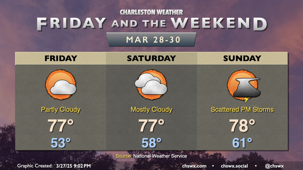
Quiet weather continues for a couple more days, albeit with high pressure slowly losing its grip over the area ahead of the next cold front. We’ll start to warm up as southerly flow develops over the area; expect to start Friday in the low to mid-50s, warming to the mid-to-upper 70s in the afternoon under partly cloudy skies. More clouds filter into the area for Saturday as a bit more in the way of humid air works its way in; expect a warmer start in the upper 50s with highs topping out once again in the mid-to-upper 70s, governed by the increased cloud cover.
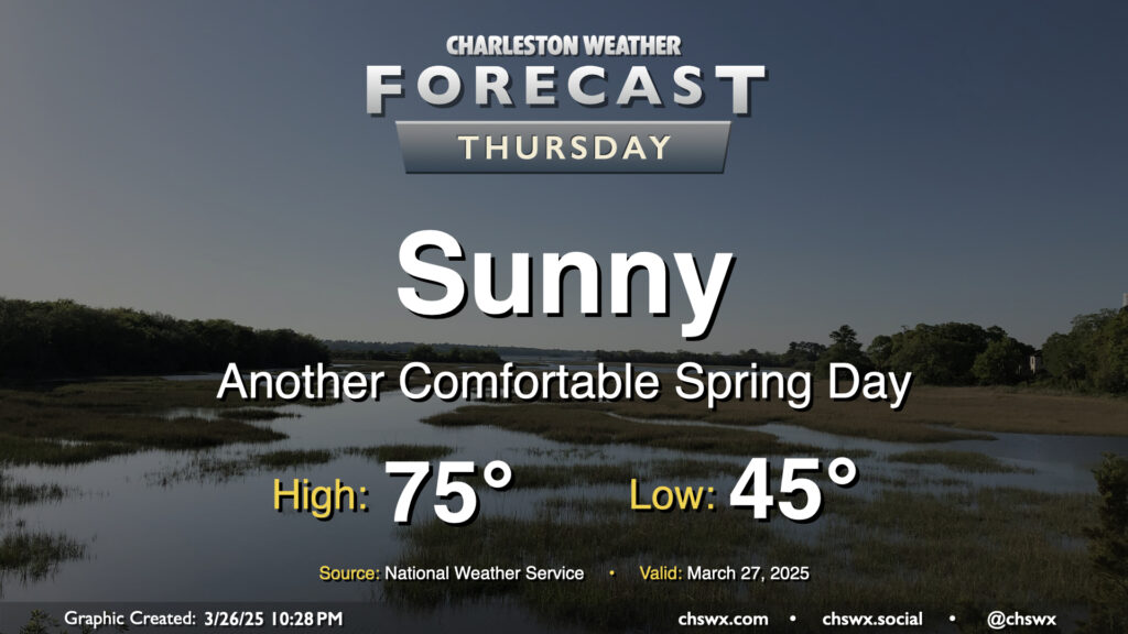
Another nice day is ahead for Thursday as high pressure slides by to our north. Temperatures start in the mid-40s, warming to the mid-70s under sunny skies for one more day. With the center of high pressure shifting more north of the area, winds will swing around more to the northeast and the east. It’ll be another dry day, relative humidity-wise, especially away from the coast as dewpoints mix down to the 30s in the afternoon. An inland-moving seabreeze will send dewpoints up into the low 40s as we get later into the day, but it’ll still feel quite comfortable outside.
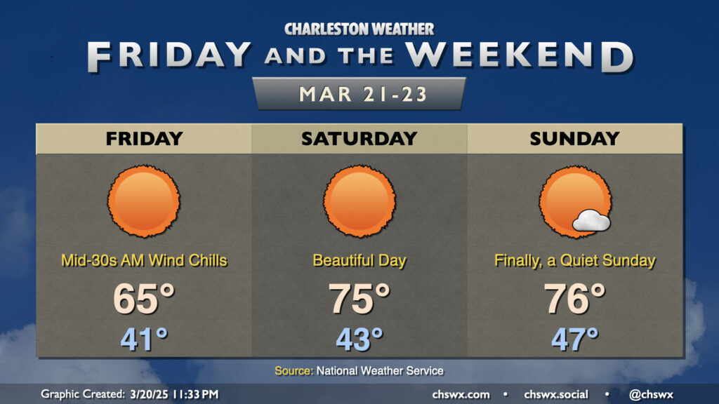
We’ve got a nice stretch of weather ahead for Friday and the weekend as high pressure rules the meteorological roost for a few days. Friday will start on a chilly note with lows in the low 40s feeling closer to the mid-30s thanks to elevated winds persisting through the morning. Temperatures Friday only top out in the mid-60s despite full sunshine owing the cooler and drier air continuing to push into the area.
The cool air advection shuts off on Saturday, though, and temperatures respond quite nicely to kick off one of the better weather weekends in a while. After another low-40s start, expect highs to peak right in the mid-70s in the afternoon with unfettered sunshine. And if you like Saturday, Sunday starts a touch warmer but ends up pretty much in the same place in the afternoon with highs in the mid-70s. Really, the only fly in the ointment is all the pollen — but such is life in March.
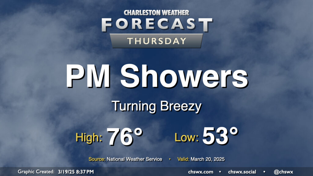
Showers return to the forecast on Thursday as a cold front moves into the area. We’ll get off to a comfortable start, with temperatures in the low-to-mid-50s to start the day. The front should show up later in the day, and we’ll get some rain-free time in, warming to the mid-70s before showers arrive. Model guidance brings the rain into the area by mid-afternoon and gets it through the area about 2-3 hours later. The rain won’t amount to much; about a quarter-inch at most. It’ll turn breezy as the front moves by, with gusts 20-30 MPH possible. Once it’s through, we’ll start to cool down heading into the overnight.
Warm weather continues for Friday and the weekend ahead of our next storm system on Sunday, which could bring us a round of strong to severe thunderstorms.