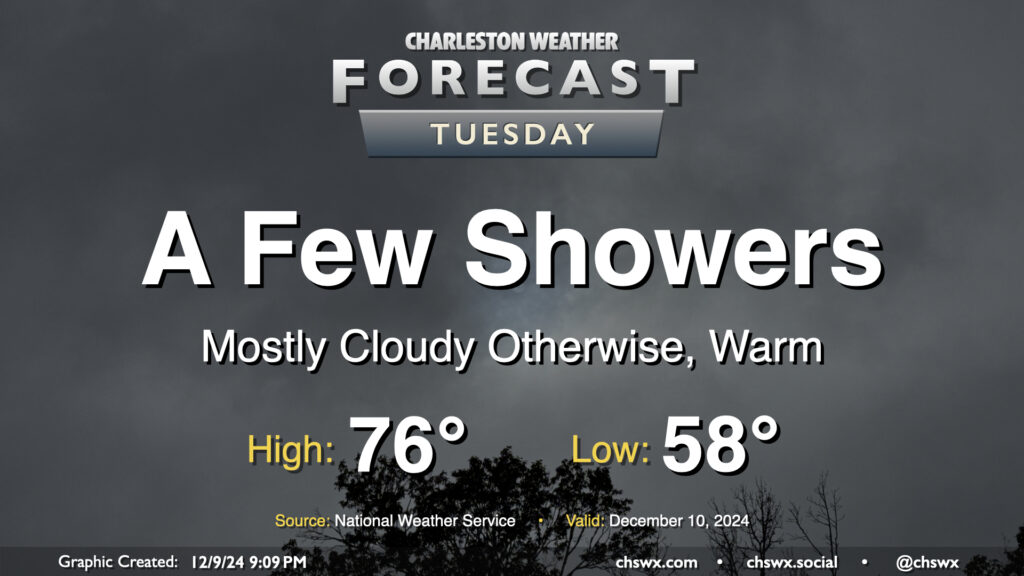
More cloud cover (with a few peeks of sun, especially early) is expected on Tuesday, but despite this, warm, humid air will continue to pump into the area ahead of a slow-moving cold front. This will make for a very mild day, with lows in the upper 50s warming to the mid-70s in the afternoon — some 10-12° above normal for December 10. We’ll also see the risk for some showers from time to time, but we’ll get rain-free time, too, especially midday.
We’ll add a little amplitude to the temperature rollercoaster as we get into the second half of the work week as one high pressure departs and another builds back in.
A shot of cold air will drive temperatures back below freezing for Tuesday morning, with some upper 20s likely inland. The metro area should stay closer to the low 30s, but tomato, tomahto — it’s just gonna be cold. A decent northerly breeze will drive wind chills down into the mid-20s, too. Make sure you’ve got pets and plants in a safe and warm place overnight. Temperatures will struggle to the upper 40s at best in the afternoon despite plenty of sunshine, indicative of just how frigid of an airmass we’ve got to work with on Tuesday. Bundle up!
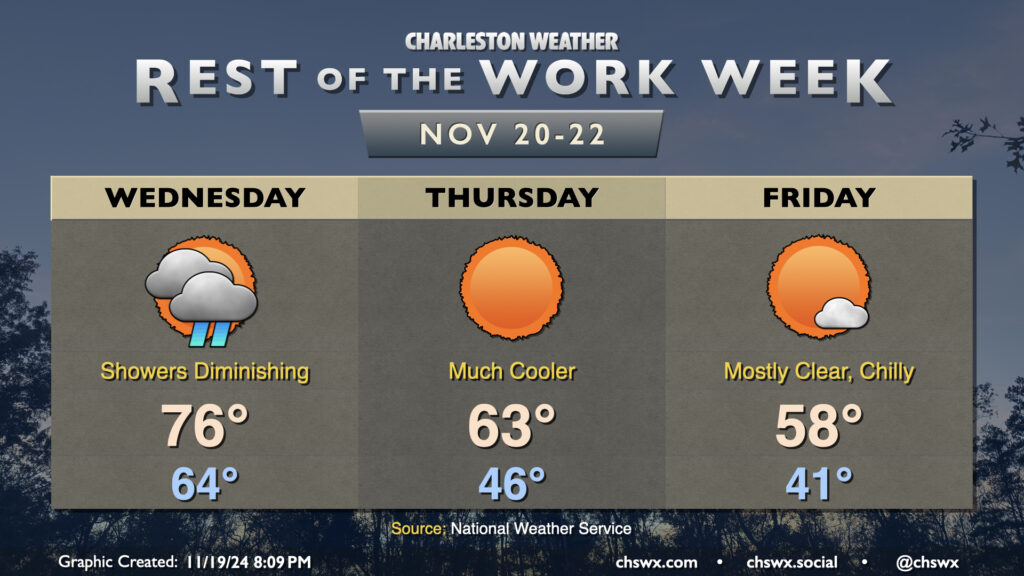
Showers will move into the area overnight and persist into a good chunk of Wednesday as a cold front moves by. We start Wednesday in the mid-60s, warming to the mid-70s in the afternoon. Showers should scour out by early evening, and from there, cooler and drier air will begin to work into the area. The airmass change will be very noticeable this go-around; we’ll start Thursday in the mid-40s, warming to the low-to-mid-60s in the afternoon at best. Friday will be even cooler, with lows in the low 40s warming to just the upper 50s in the afternoon despite full sunshine, roughly 10° below the normal temperature for November 22 and more reminiscent of normal highs for early January!
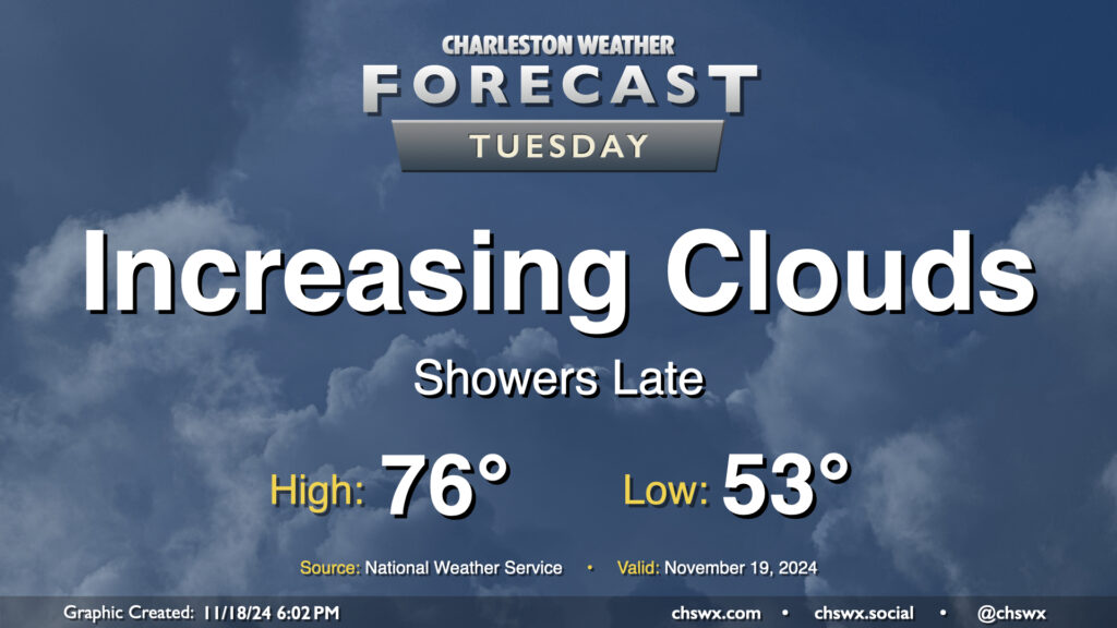
We’ve got another unseasonably warm day ahead Tuesday ahead of a front that will sweep through on Wednesday. Ahead of that front, we’ll see an increase in cloud cover, and eventually some shower activity later in the afternoon into the evening and overnight. Temperatures Tuesday start in the low to mid-50s, warming to the mid-70s in the afternoon. Southwesterly winds will keep the tides at bay, thankfully, and we should fall short of the coastal flooding threshold with the mid-morning high tide, with no coastal flooding expected for the next few days at least.
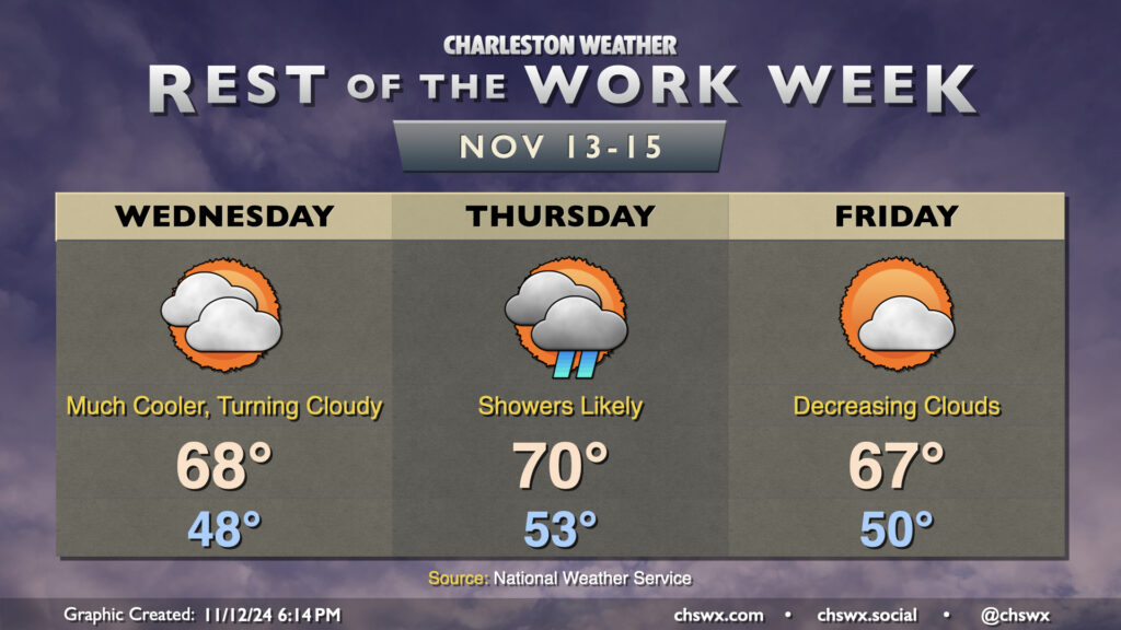
Cooler and drier air will push in overnight as high pressure wedges into the area from the north. This will make for a much cooler day on Wednesday than we’ve had in quite some time, with lows in the upper 40s in many spots away from the coast expected in the morning. High temperatures should only peak in the upper 60s as cooler air moves in. Increasing cloud cover as the day will also assist in keeping temperatures a little lower, too.
High pressure will break down Thursday as a cold front approaches, driving up the risk for showers particularly from midday into early evening. We’ll start the day in the low 50s, warming to around 70° in the afternoon. Rain should generally be on the light side, though some pockets of heavier rain can’t be totally ruled out, either.
The front clears the area for Friday, and cloud cover scours out during the day as a result. Temperatures, though, will once again struggle to the mid-to-upper 60s as cool air behind the front continues to push in. This sets the stage for a seasonably nice weekend, though, with lots of sunshine expected. Expect highs in the upper 60s Saturday, with low 70s returning for Sunday, right around where we should be at the midpoint of November.
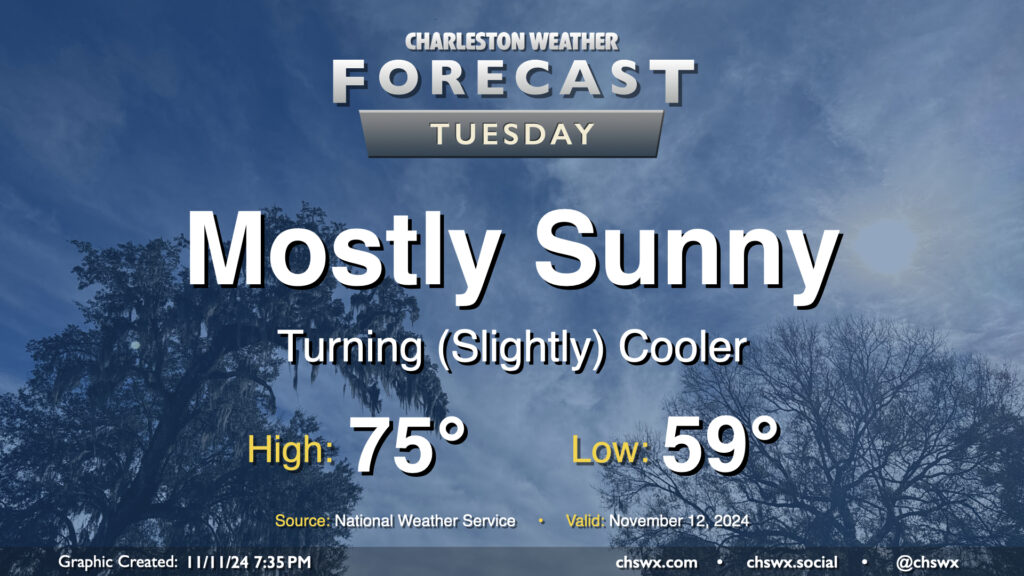
A front swinging through tonight will help start a cooldown across the area that will bring temperatures more in line with where they should be for this point in the year. Lows on Tuesday start in the upper 50s to around 60°, with highs only heading to about the mid-70s despite mostly sunny skies. Drier air will be moving in throughout the day, especially as winds start to go around to the northeast, and it should overall feel pretty nice especially given the recent swampiness that’s characterized November thus far.
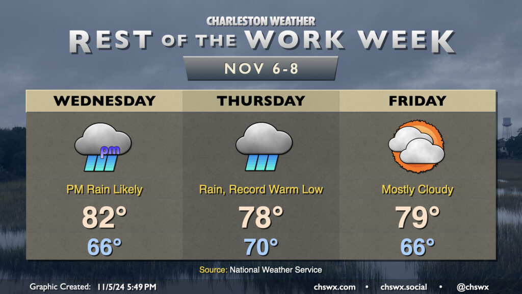
Many stations recorded a good bit of measurable rainfall yesterday, and it looks like we have another round of it coming Wednesday evening into Thursday courtesy of the interaction of Tropical Storm Rafael in the Gulf and a cold front. Meanwhile, the airmass remains awfully tropical for early November, and we should set a new record warm low temperature on Thursday as a result.
Wednesday will start out quiet and mild (mid-60s lows expected), but expect showers to increase across the area as we get into the afternoon and evening hours, including around the evening commute. Temperatures top out in the low 80s before rain overtakes the area. We could even hear some rumbles of thunder thanks to the spring-like dewpoints around 70-72°.
Rain continues on Thursday and should be around for much of the day. We start the day around 70° — which would be a record warm low for the date — and warm only to around the upper 70s given the cloud cover and ongoing rainfall. Many spots will end up with 1-2″ of rain before this is over, with even higher amounts possible west of 26. It’s much-needed rain, and given that it’s been so dry, the flooding risk is low (provided pockets of heavier rain don’t train over the same urban areas).
High pressure builds back in for Friday and into the weekend, giving us a chance to dry out. Warmer-than-normal temperatures will persist, with highs in the upper 70s to low 80s continuing each day well into next week.
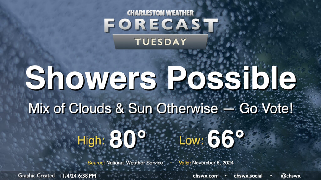
A few showers will be in the cards as we head to the polls for Election Day on Tuesday, but it won’t be a washout and should be minimally disruptive to voting. We start the day about 15° above normal with lows in the mid-60s, warming to 80° in the afternoon. We’ll see some peeks of sun from time to time as well. Go out and make your voice heard!
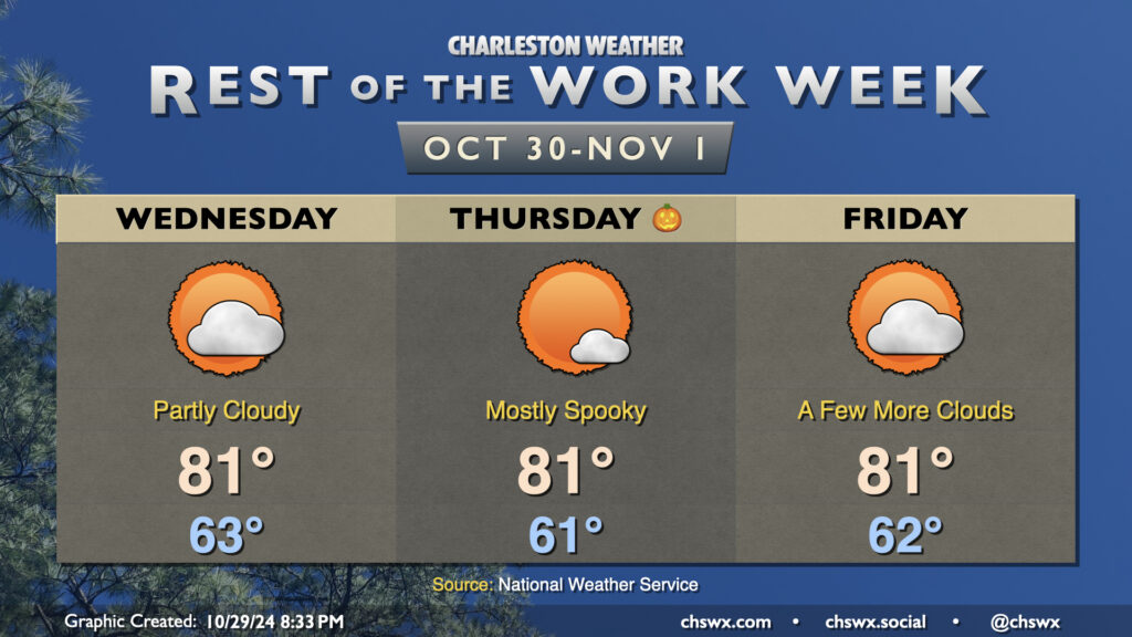
After a coastal trough pushed ashore with a trace of rain (or more in a few lucky spots), the weather turns quiet once again on Wednesday, with another stretch of dry weather expected well into next week. We start the day in the low 60s, with temperatures warming back to the low 80s in the afternoon under partly cloudy skies. We’ll copy, paste, and delete a few clouds for Halloween, starting once again in the low 60s and warming to the low 80s in the afternoon. A few more clouds kick up for Friday ahead of a weakening front, but otherwise, temperatures do the same ol’ thing — low 60s to start, low 80s in the afternoon.
A small cooldown arrives this weekend, but that’ll take temperatures down from the low 80s to the upper 70s — definitely not a return to more seasonable weather, much less any sweater weather. The Climate Prediction Center continues to favor warmer than normal weather over the next couple weeks, while above-normal precipitation is a possibility heading into the second week of November. Stay tuned on that, though.