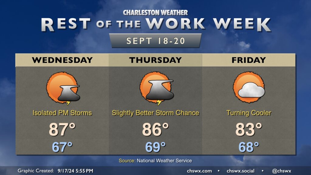
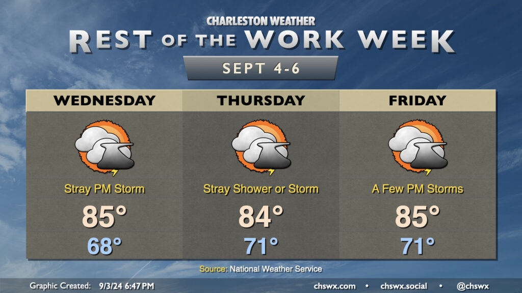
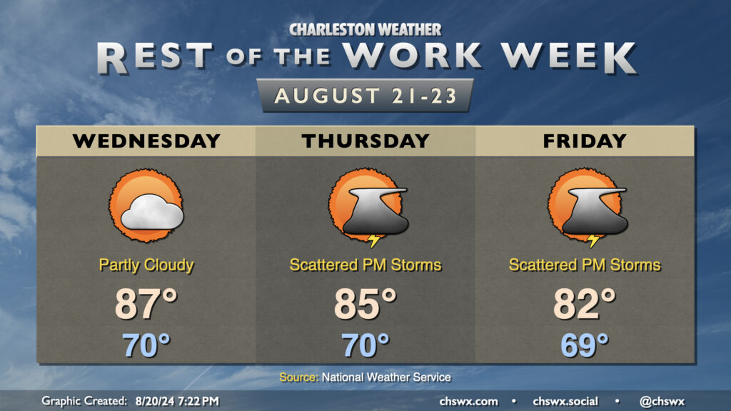
After a beautiful Tuesday — I’m sitting outside as I write this, in fact — we will see a bit more in the way of moisture work its way into the area over the next couple days. It’ll also turn a bit warmer, with highs in the upper 80s Wednesday and solidly in the mid-80s on Thursday.
There will be the risk for some afternoon showers and maybe a thunderstorm each afternoon over the next couple days as a front gets closer. The risk for rain is slightly higher on Wednesday as the front gets through the area.
Once that front gets through, though, a stretch of excellent weather will begin. Friday begins a stretch of several days of temperatures at or below normal, with partly cloudy to mostly sunny skies each day through at least the middle of next week as high pressure takes command of the local weather situation. Should be quite enjoyable!
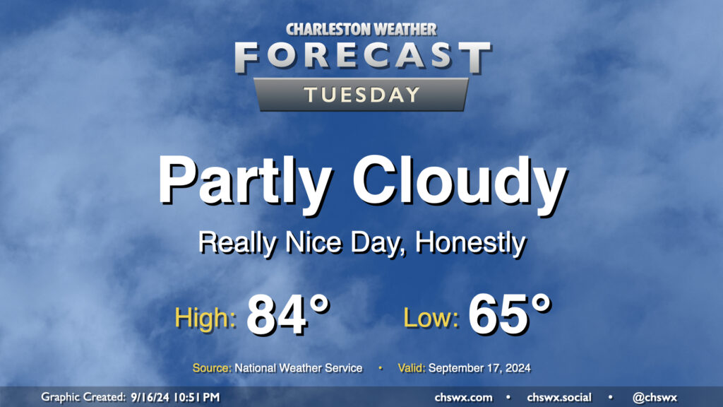
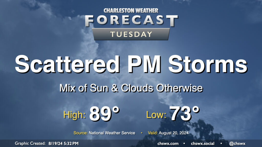
After our largely uneventful brush with Potential Tropical Cyclone Eight, we have a pretty nice weather day on tap for Tuesday as dry air wrapping around the back end of the system hangs around for one more day. We’ll start the day comfortably in the mid-60s, warming to the mid-80s in the afternoon under partly cloudy skies. Dewpoints run into the mid-to-upper 60s, so it’ll feel a little humid, but not too bad.
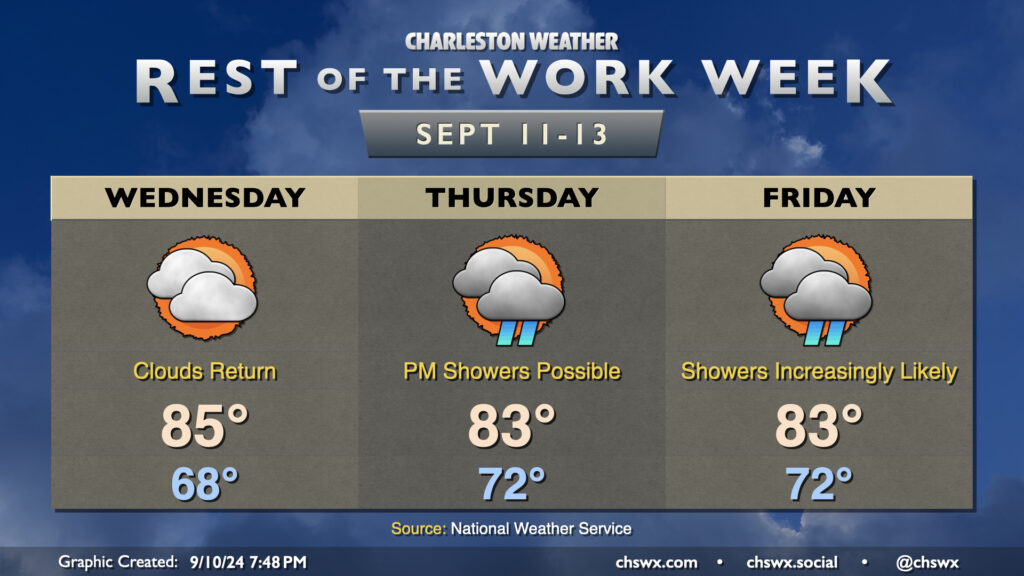
After a beautiful Tuesday featuring plenty of sun and comfortably warm temperatures, cloud cover returns to the area as moisture from Hurricane Francine lifts northward across the area. While Francine won’t have direct impacts in the Lowcountry, its northward advance into the Mississippi River valley will shove high pressure offshore, allowing the stationary front that has been draped to our south to start to retreat northward a bit. Upglide across the frontal surface and high pressure will help produce showers and maybe a few thunderstorms as well.
Wednesday looks to be rain-free with merely an uptick in cloud cover and dewpoints. We’ll start the day much warmer than we started Tuesday, with lows generally in the upper 60s to around 70°. Temperatures warm to the mid-80s in the afternoon despite the increasing cloud cover.
Much of the metro should get Thursday in rain-free as dry high pressure continues to hang tough at the surface, but we’ll start to see that erode with time, introducing some shower chances to the forecast starting Thursday afternoon. Cloud cover and persistent northeasterly winds will cap highs to the low to mid-80s after starting in the low 70s. Moisture more fully overtakes the area by Friday, and this leads to increasingly numerous showers and maybe some thunderstorms across the area as we get through the day, with rain chances peaking in the afternoon and evening hours. Once again, highs will be limited to the low to mid-80s with the cloud cover and expected rain.
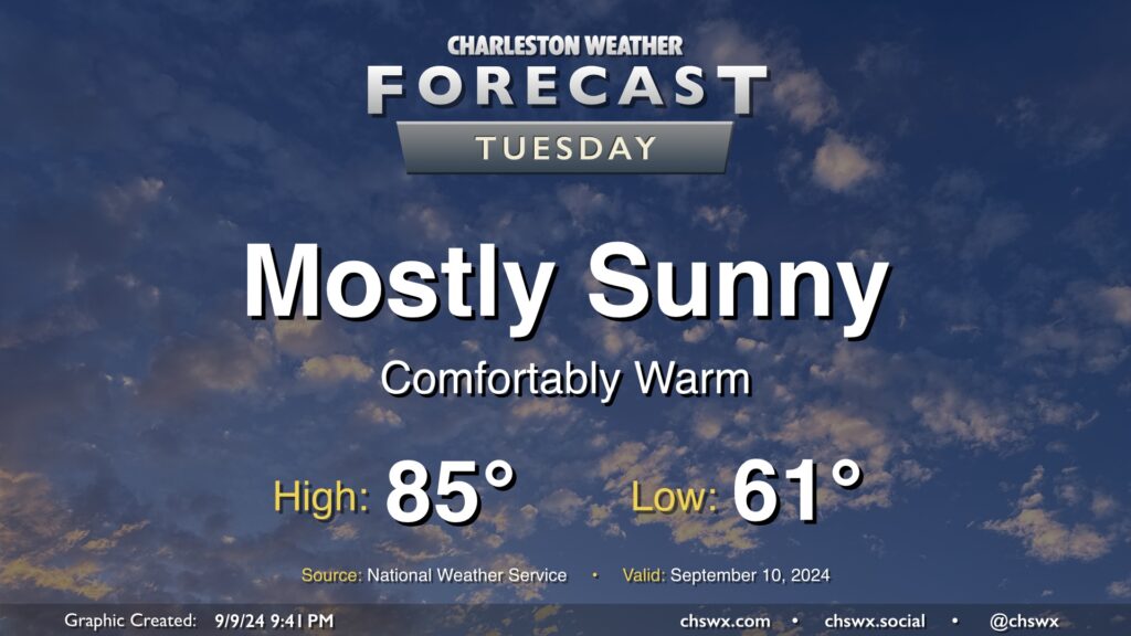
Tuesday looks like a rather nice day in our part of the world with mostly sunny skies, a seasonably cool start in the low 60s, and highs in the mid-80s with relatively low humidity as high pressure’s influence on the area peaks before moisture returns starting Wednesday. I hope you can take advantage! Unsettled weather will return to the area by Thursday.
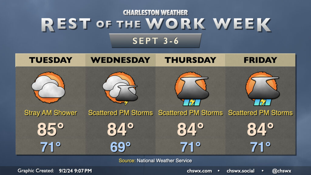
Tuesday ended up being a rather nice day across the area as the low-level cloud cover that was originally anticipated didn’t quite materialize. Unfortunately, that reprieve may not last as the stationary front offshore buckles back toward the coast a bit more starting Wednesday. This should help spread some cloud cover back into the area, though the best shower and storm chances will reside closer to the coast. Northeasterly flow will keep temperatures well in check, with lows in the upper 60s Wednesday followed by low 70s Thursday into Friday. We’ll see highs continue to peak in the mid-80s, which remains a few degrees below normal for this point in the year.
Rain chances will tick up heading into Friday as a little more moisture works back into the area. We’ll see rain chances peak Saturday into Sunday before another front moves by for Monday, which should bring another round of cooler and drier air into the region for next week.
A front will get through the area overnight into Tuesday morning, bringing with it a cooldown that will last for the rest of the week as high pressure wedges southward into the area. Lingering showers should end Tuesday morning, and we should get much of the rest of the day in without any additional measurable rainfall. Clouds will hang around, though, and this will be commonplace for much of the week with the nearby front and ongoing high pressure wedge.
Tuesday’s temperatures will be fairly representative of what we have in store for the rest of the week. Expect lows around 70°, with perhaps some 60s further inland. We’ll warm to the mid-80s in the afternoon, tempered by the northeasterly winds and cloud cover. Dewpoints on Tuesday will run just in the mid-60s, making it the driest-feeling day of the rest of the week as they’ll trend back up to the upper 60s on Wednesday and back to around 70-71° on Thursday and Friday as the stalled front buckles back northward. Shower chances with some rumbles of thunder head up starting Wednesday afternoon and get a little higher Thursday and Friday thanks to the aforementioned front and the return of more quality surface moisture. We’ll keep this going into the weekend, too, before another front sweeps through the area with a reinforcing shot of cooler and drier air to kick off next week.
Warm and muggy conditions continue for the rest of the work week as high pressure ridges aloft and at the surface. This should help keep showers to a dull roar, though I suppose with the airmass we can’t ever totally rule out a rogue popup shower (like we saw today).
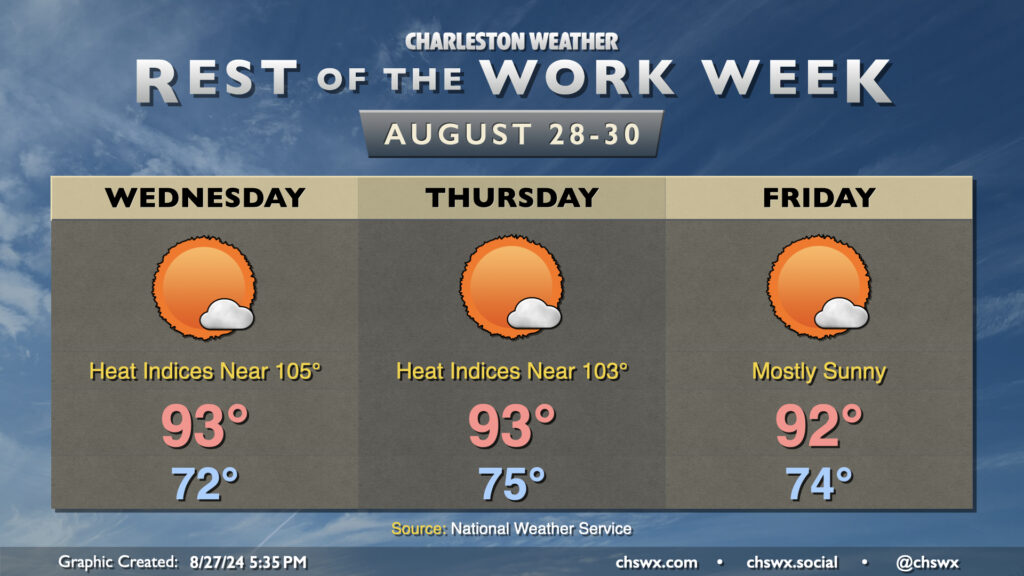
We may start Wednesday with some fog once again, but that should mix out by 9-10am to yield a mostly sunny day with highs in the low to mid-90s. Dewpoints in the low to mid-70s will combine with those air temperatures to make it feel closer to 105° in the height of the afternoon, so be sure you’re taking frequent breaks and getting plenty of water if you’re outside during that time.
We’ll keep this going Thursday into Friday, with lows in the mid-70s each morning yielding to highs in the low 90s each afternoon with just a few clouds from time to time. The stacked high pressure will give any enterprising updraft trying to become a shower a very, very hard time, and rain-free conditions are expected as a result.
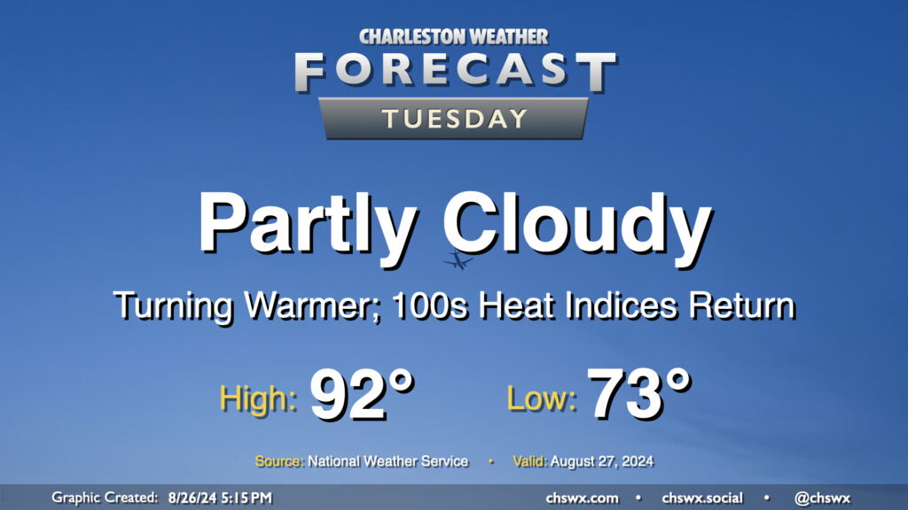
High pressure will bring a pause in the rain and a further uptick in temperatures starting Tuesday. We start the day in the low to mid-70s (warmer near the coast), warming to the low 90s in the afternoon under partly cloudy to mostly sunny skies. With 70s dewpoints continuing their comeback, expect heat indices in the low 100s to return to the area as well — a fair bit warmer than we’ve been used to recently, but staying below the heat advisory thresholds we got to know very well during July.
The rest of the work week will feature a cooling trend as high pressure wedges into the area from the northeast and troughing aloft persists. Wednesday should feature a lower storm chance than we’ve seen the past couple days as some drier air takes hold across the area. Temperatures start around 70°, warming to the mid-to-upper 80s in the afternoon with dewpoints in the upper 60s expected.
Thursday into Friday will feature even cooler temperatures as the wedge intensifies over the area; expect mid-80s on Thursday and low 80s on Friday. The intensifying high pressure should lead to a tightening pressure gradient which will drive some gusty winds, particularly around the coast. The onshore winds combined with the recent lunar perigee will also promote coastal flooding around times of high tide (both morning and evening) starting Wednesday evening through at least Friday. Right now generally minor flooding is expected, which is enough to close some of the more vulnerable roads in downtown Charleston.
Shower and thunderstorm chances come back into play for Thursday and Friday as well as more moisture starts to work back into the area, with the best chances of rain closer to the coast. Inland locations may even stay rain-free where drier air is expected to hold firm. No severe weather is expected, though a downpour or two can’t be totally ruled out.
Tuesday looks a lot like Monday did (in the weather department, anyway) as a front continues to meander nearby, keeping the risk for a few showers and thunderstorms in the forecast in the afternoon primarily east of 17-A. Temperatures will follow a similar curve as well — we start in the low 70s (warmer toward the coast) and warm into the upper 80s to around 90° in the afternoon.
As far as storms go, a few folks could see some locally heavy rain thanks to slow storm motions, but otherwise, no severe weather is expected.