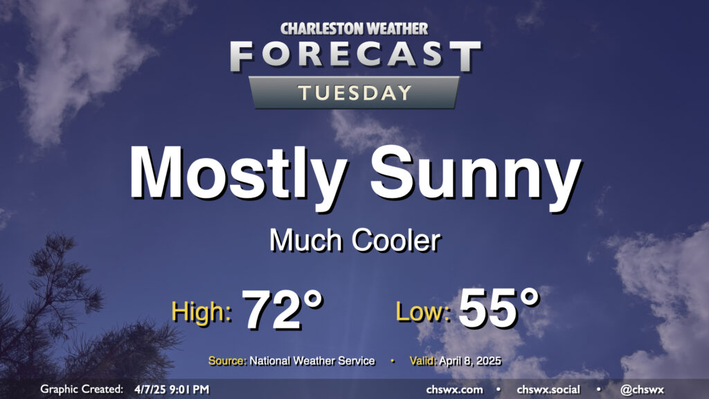
After a cold front comes through late Monday, Tuesday will turn out to be a much cooler and quieter day (weather-wise, anyway) as the front sweeps away the past week and change of more summerlike conditions. We’ll start Tuesday in the mid-50s, warming to just the low 70s in the afternoon under mostly sunny skies. It’ll feel quite different, but a bit more like early-to-mid-April, too.
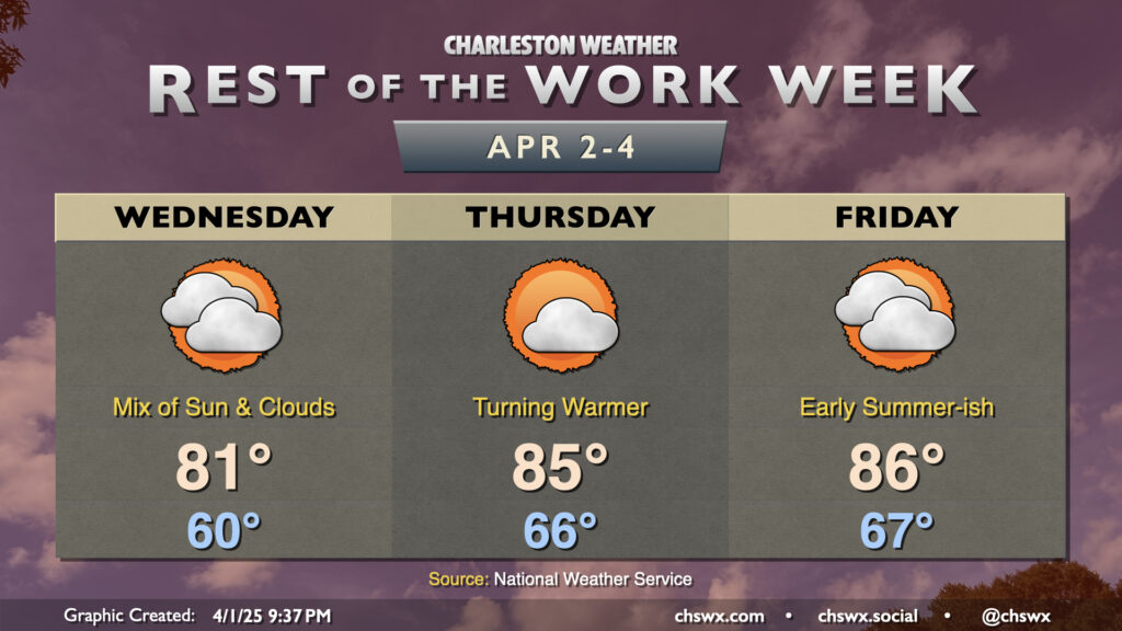
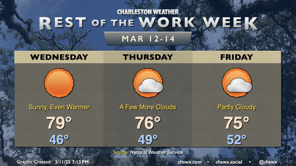
High pressure will continue to keep the weather generally on the quiet side for the rest of the work week. It’s also going to help contribute to the warmest weather so far this year starting Thursday and lasting into the weekend. A bit of onshore flow will keep Wednesday’s temperatures capped to the low 80s in the afternoon under a mix of sun and clouds. From there, winds go more southerly as high pressure at the surface slips offshore. Ridging building in aloft creates a bit of a “heat dome,” and the combination of both will help bring along the warmest weather so far in 2025. Expect highs to top out around 85° on Thursday and 86° on Friday with a mix of sun and clouds each day. Lows will be even warmer, with mid-60s expected each morning that could challenge record warm low temperatures. This warmth looks to stick around into Bridge Run weekend, too, before the next front arrives Sunday night into Monday.
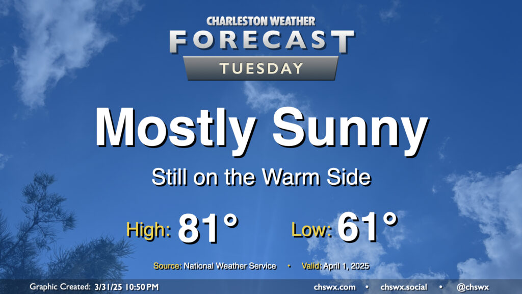
After a raucous evening, we’ll have a much quieter Tuesday ahead as high pressure builds back in behind the cold front. The post-frontal airmass won’t feel much like a cold front came by, though, as temperatures will only come in a couple clicks below where they did on Monday (83° ended up as the day’s high temperature). Generally speaking, expect lows in the low 60s to warm to the low 80s in the afternoon under mostly sunny skies.
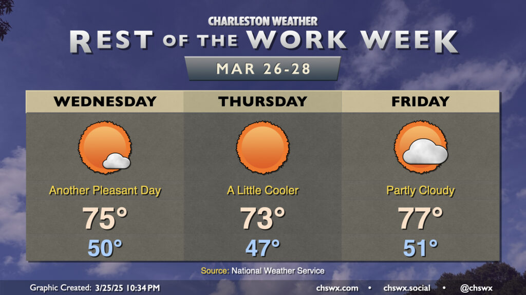
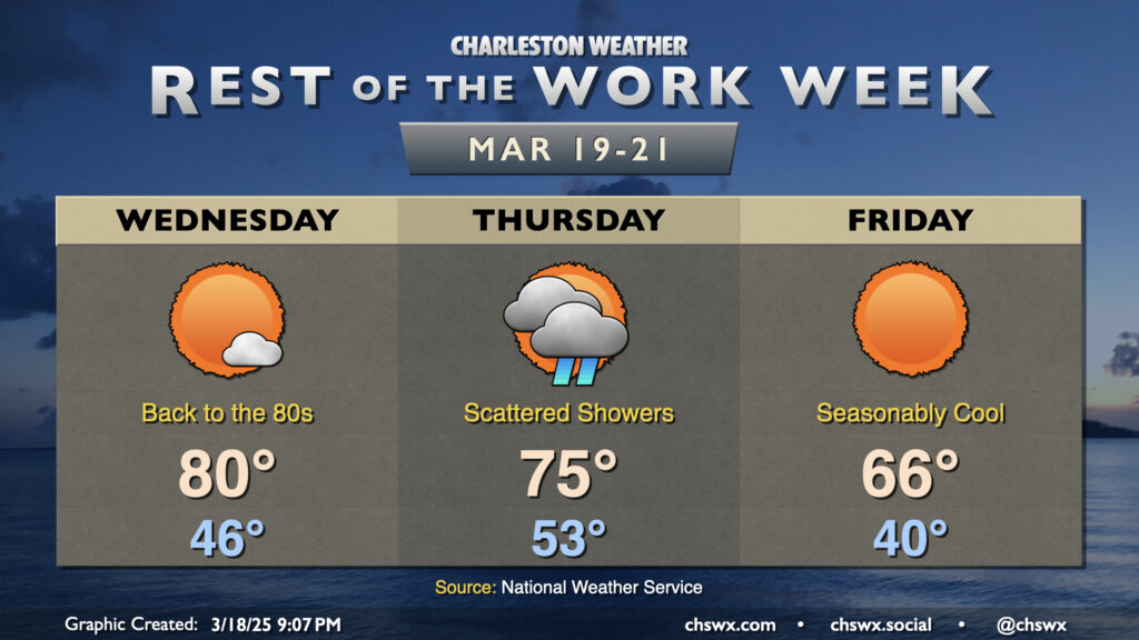
Quiet weather continues for the rest of the work week as one dry front slips through followed by another area of high pressure. Despite the frontal passage, winds out of the northwest will keep Wednesday a bit more on the warm side as highs head to the mid-70s after a start right around 50°. It’ll be a touch breezy, but nothing too horrendous (though we’ll need to mind relative humidities and any stronger gusts for possible enhanced fire danger).
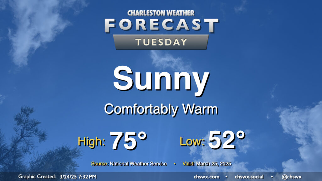
After a front swings through late Monday, quiet weather takes root for the rest of the week starting Tuesday. And what a nice day of weather Tuesday will bring: after starting in the low 50s, temperatures warm into the mid-70s in the afternoon with plenty of sunshine and low humidity. Once again, a shame the pollen is such a thing this time of year, because it’s looking like a beautiful day to get out and about where you have opportunities to do so.
Warmth will peak Wednesday as high pressure slips offshore, sending winds back around to the south and highs up to around 80° in the afternoon under mostly sunny skies. We’ll see a few more clouds move in late as a cold front draws closer to the area, but Wednesday will remain rain-free.
We’ll continue this benign stretch of weather for the rest of the work week, but as we head into the weekend, we’ll need to keep an eye on a storm system that could bring another round of rain and thunderstorms for Sunday.
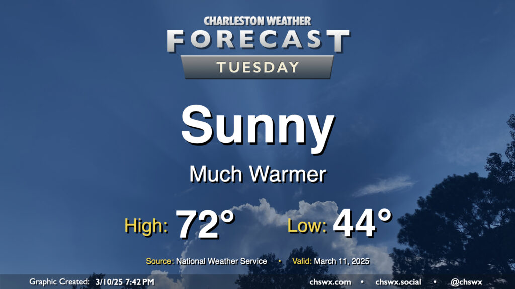
Much more sunshine is in store for Tuesday as low pressure pulls away from the area at the surface and aloft. This will help warm things up, too — after a mid-40s start, downslope winds out of the northwest and the aforementioned sunshine will push highs to the low 70s in the afternoon, a couple degrees above normal for March 11. Overall, a much nicer day than Monday (weather-wise, anyway).
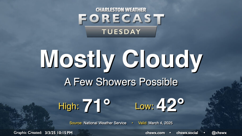
After a sunny but chilly Monday, temperatures begin to warm up ahead of Wednesday’s cold front as we get into Tuesday. We’ll also see cloud cover begin to thicken up as well, and there could even be a few showers at times as Atlantic moisture builds in. We start the day in the low 40s — about 10° warmer than the frosty start we felt on Monday morning — and head back to the low 70s in the afternoon. It’s going to be breezy as well — winds will generally run between 10-15 MPH, but could gust to 20-25 MPH at times.