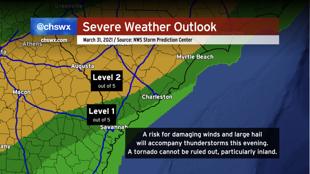
We’ll have a risk of some strong to severe thunderstorms later this afternoon into this evening as a sharp cold front swings through the area. We’ve had plenty of sunshine thus far, and that is certainly helping the atmosphere destabilize ahead of said front. Damaging wind gusts are the primary concern, but a tornado cannot be ruled out somewhere on the leading edge of the line as well. The greatest risk of severe weather generally lies along and west of 17-A as daytime heating and marine influences stabilize things closer to the coast, but severe storms will be possible pretty much anywhere in the Tri-County this evening; NWS is thinking between 6PM and midnight for our neck of the woods.
Stay close to reliable weather sources this afternoon and be ready to take action in case warnings are issued.
We’re once again in the gloom with periods of heavy rain moving through the area this afternoon. This is good, though, as these clouds and rain are reinforcing the inland cold air damming wedge which, in turn, is keeping a warm front from advancing too far north into the Lowcountry. All this to say that the severe weather threat, which was never terribly high in the Charleston metro to begin with, remains rather marginal. If the warm front does sneak a little further north than projected, the risk for damaging wind gusts would come up some. The best risk for any severe storms today remains southwest of us in Georgia.
The main issue today, especially inland of 17-A, will be the potential for flooding in spots. Some areas have already received 2-3” of rain in the I-95 corridor with more to come through tomorrow. Closer to the coast, the forecast continues to call for 1-2” through tomorrow with locally higher amounts.
As always, I’ve got an eye on it. Keep an ear out in case conditions change quickly, but so far, so good.