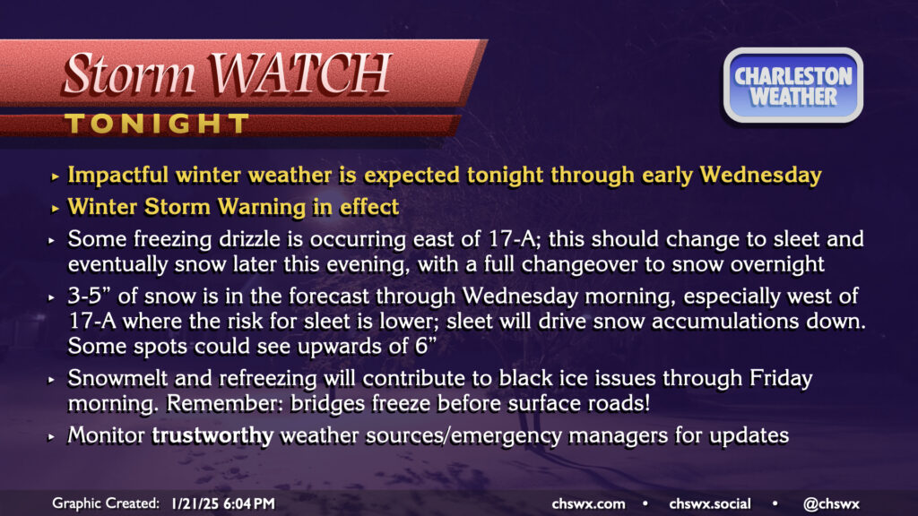
A Winter Storm Warning continues through noon Wednesday as winter weather is beginning to affect the area this evening. So far, we’ve seen some freezing drizzle primarily in the US-17 coastal corridor and points east, with trace accretion reported in places like James Island, Mt. Pleasant, and even at my home in West Ashley. Some bursts of sleet have been reported to be mixing in at times, particularly around Johns Island. Ice pellets have also been reported at the airport, and so we officially have a trace of snow so far today in North Charleston (sleet and snow are functionally considered the same accumulation in the historical climate record).
A special evening weather balloon release continued to indicate a pocket of warmer air aloft that is contributing to primarily freezing rain and sleet so far. The atmospheric column should continue to cool, though, and a changeover to all snow is still expected overnight into early Wednesday morning. By the time all is said and done, many spots should have between 3-5″ of snow. Areas closer to the coast may see accumulations impacted if more sleet falls, while others who stay in the snow longer could see upwards of 6″. This is a pretty stark upward revision from previous forecasts, but thus far all we’ve seen this storm do to our west is overperform. We’ll see how things shake out. Regardless of how much falls, we can still expect some tough road conditions tonight into Wednesday morning even after snow ends. The best course of action is to stay put tonight if at all possible, leaving roads open for essential and emergency workers.
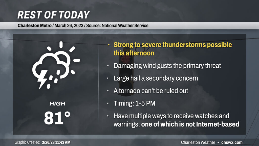
A few strong to severe thunderstorms are possible this afternoon as waves of energy aloft interact with a nearby stationary front. As of this writing, a band of showers and thunderstorms was located just north of the Tri-County, stretching across central GA, the CSRA, and the Midlands. Outflow from these storms may, in time, trigger additional thunderstorm formation closer to the metro area. Shear and instability profiles are supportive of a few organized severe thunderstorms. Straight-line winds are the primary concern, though steep mid-level lapse rates seen on soundings are also supportive of large hail within the strongest storms. The overall tornado risk is low, but where boundaries interact, a quick spin-up can’t be ruled out.
Stay weather-aware this afternoon. Make sure you have more than one way to receive a weather warning, including one that doesn’t use an Internet connection. Social media should be a supplementary way of receiving information, but should not be used as a sole source as those sites can go down or show information that is far out-of-date.
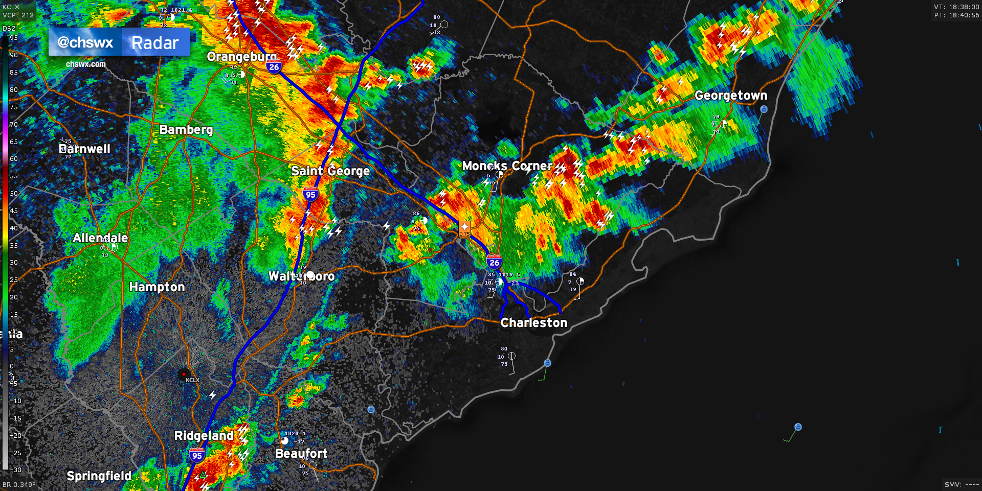
Radar is active this afternoon with two distinct areas of thunderstorms that look to merge over the next hour, potentially bringing storms further eastward toward the coast this evening. The first area is situated across the inland-moving seabreeze, which roughly sets from Ridgeville through Moncks Corner to Jamestown. Along this line, we’ve seen hail to the size of pennies reported in Summerville with a risk of strong wind gusts approaching 55 MPH. The second area to watch is coming in from the west, aided by a mid-level impulse and riding a fairly potent outflow boundary. This outflow boundary looks to collide with the seabreeze over the next hour, sparking up additional thunderstorms especially to the southwest of the area and across the Santee Cooper lakes. Damaging wind gusts and large hail can’t be ruled out as the two boundaries collide. The resulting thunderstorm complex should continue to head eastward as the afternoon goes on, with thunderstorms likely reaching the coast by early evening.
Remember: When thunder roars, go indoors! Every thunderstorm is dangerous due to the lightning it produces.