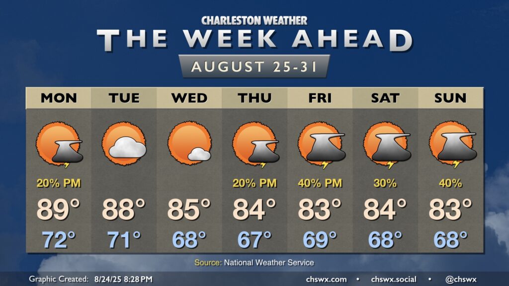
The main weather story this week will be much more pleasant than last week’s: cooler, drier air working into the area will bring along a decent early-fall preview to close out August, though a few storms will be possible heading into late week.
The week ahead starts out on a warm note with high pressure in play before turning more unsettled by the time we get into the weekend. Meanwhile, Hurricane Erin will be passing offshore, sparing us direct impacts but kicking up high surf, a risk for dangerous rip currents, and even some coastal flooding in the evenings.
After a dreary weekend, a more standard summertime pattern returns to the Lowcountry as high pressure ridges into the area aloft, finally breaking down the high pressure wedge and stalled front that’s kept us unsettled (but at least on the cool side).
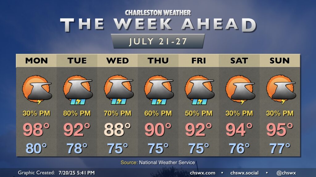
The stalled front to our south which helped bring about much more comfortable temperatures for the weekend will generally meander for the first part of the week as high pressure remains anchored well to the north, keeping our weather periodically unsettled. We’ll then transition back more toward a traditional summer pattern as we head into later in the week.
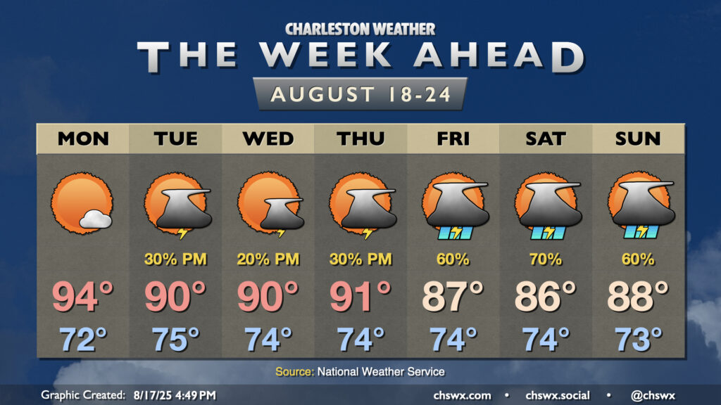
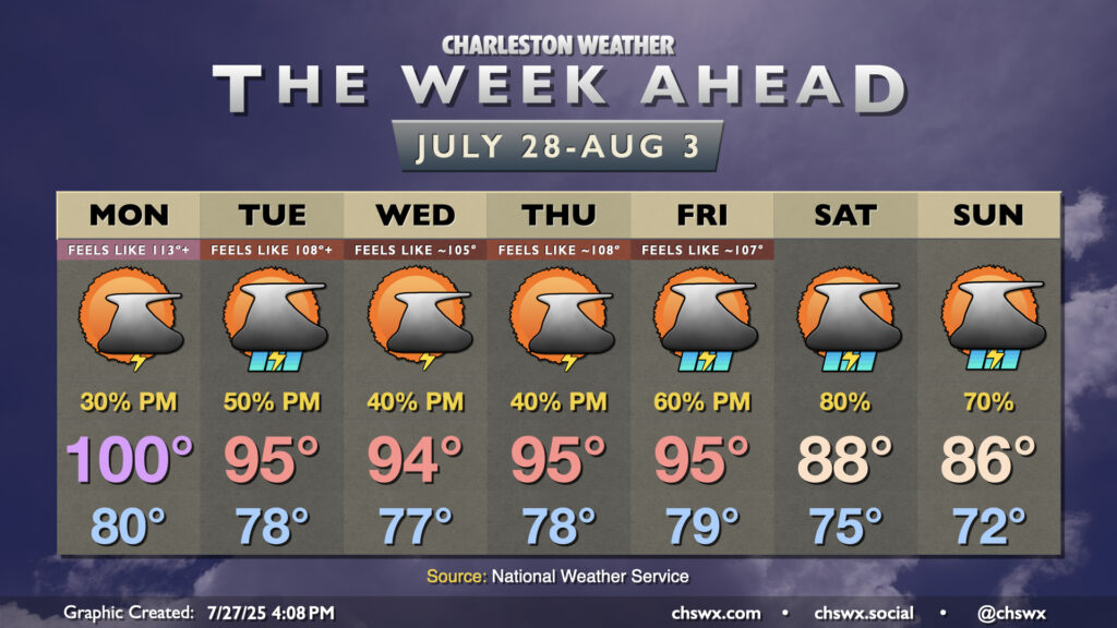
Hot weather continues for much of the upcoming week, but as the ridge of high pressure that’s baking us slides westward, that will allow for some moisture to work its way back in, inviting showers and thunderstorms to develop each afternoon on the seabreeze.
This weekend’s hot weather continues into Monday, but a more unsettled pattern will cool temperatures down back to normal (still not chilly, but not overwhelmingly hot, either) as rain chances tick back up.
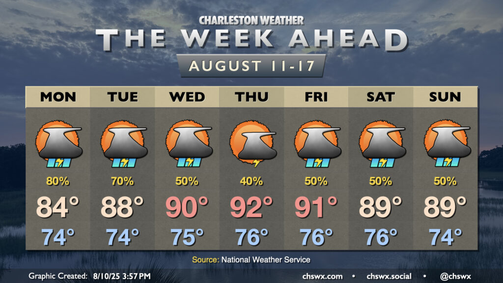
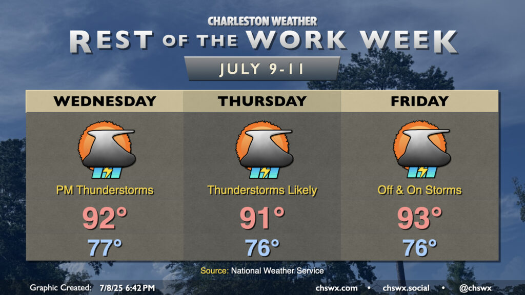
The rest of the work week will be characterized by scattered to numerous thunderstorms each afternoon as a weakness in high pressure aloft moves into the area from the west, adding to the available lift. The atmosphere will remain quite juicy (technical term), so the ingredients are largely there. A relative lack of wind shear will generally mean thunderstorms will be of the pulse variety — popping up, maturing, then collapsing in on themselves as rain-cooled air overwhelms the storm’s updrafts. Still, in these kinds of scenarios, wet microbursts can produce damaging wind gusts, and the strength of the mature updrafts can help produce hail. So, you’ll want to be on guard for the potential for a few severe storms. With all that said, all thunderstorms are dangerous because of the lightning they produce. When thunder roars, go indoors!
Temperatures will remain on the warm and muggy side, pretty much standard operating procedure for July. Lows in the mid-70s away from the coast, where temperatures will struggle to dip below 80°, warm to the low 90s each afternoon. Thunderstorms will help impart relief for some if not many of us, thankfully, keeping heat indices a bit more tame than they have been for the first couple days this week, but they will still rise to the upper 90s and low 100s before storms develop. Take it easy in the heat!
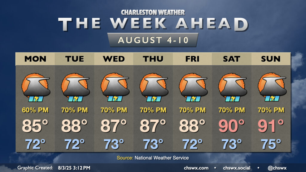
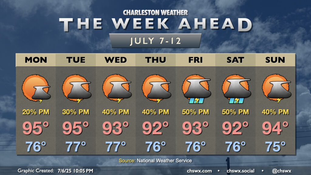
After a Chantal-cooled weekend that saw our 21-day 90° streak come to an end, this upcoming week will once again feel very much like…well, July, as temperatures soar back to the mid-90s, especially for the first half of the week, with afternoon thunderstorm chances each day.
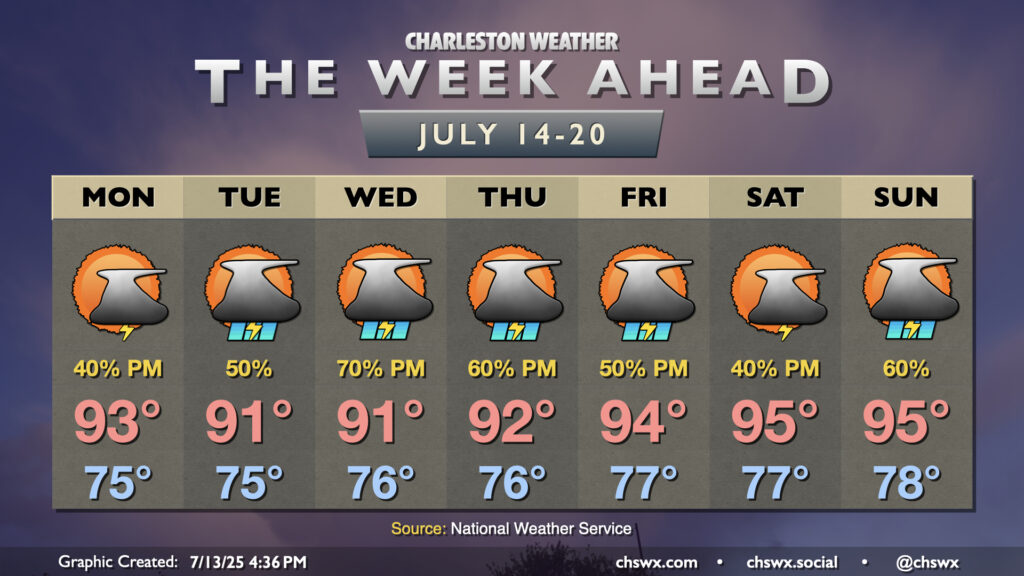
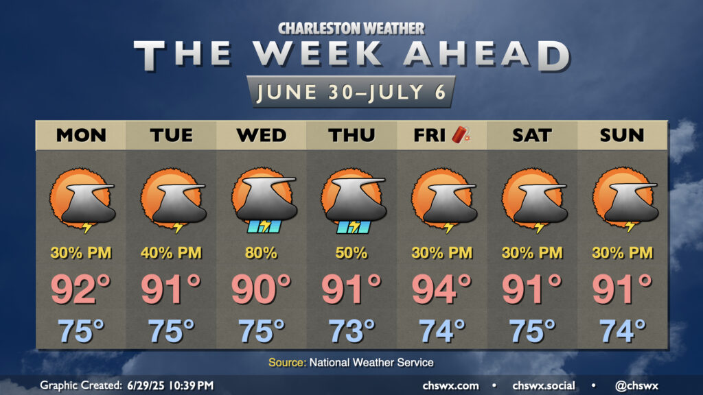
Warm, humid, and occasionally stormy days lie ahead to close out June and bring in July. (Side note: It’s insane that we’re entering the second half of 2025!) Temperatures look to remain in the 90s each afternoon, and if the forecast works out, the current 16-day streak of 90°+ high temperatures should continue through a third and into a fourth week (23 days, to be exact).
A cold front will approach the area on Wednesday into Thursday, stalling out before it reaches us (of course). This will increase the risk for showers and thunderstorms for those two days in particular, and if there’s a period that could impact that 90° streak, this is it. Regardless, it’ll still be steamy and stormy.