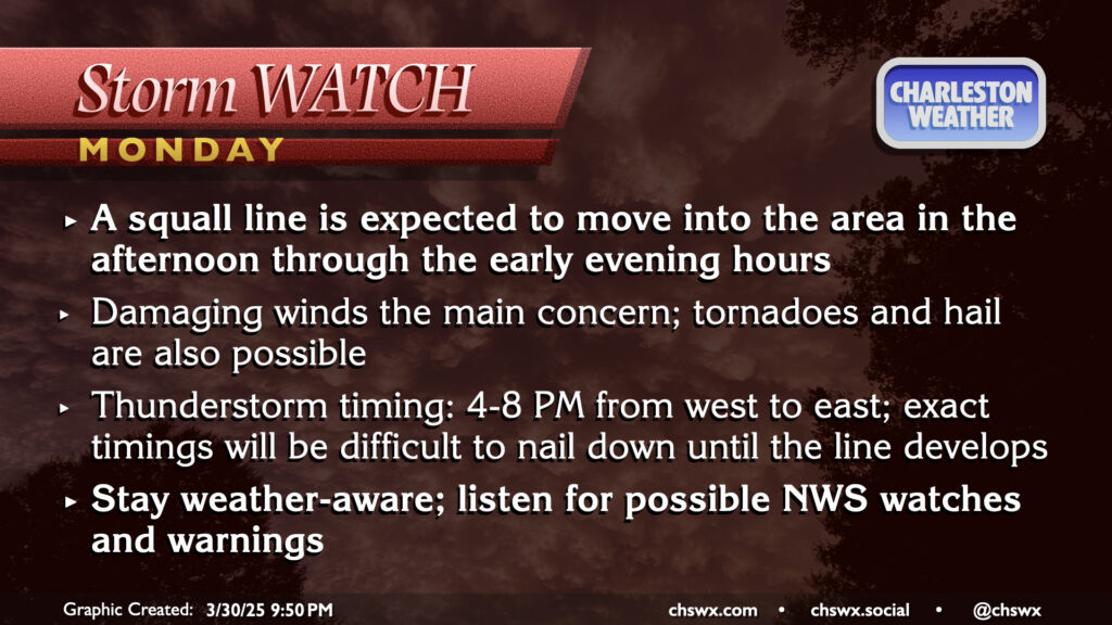
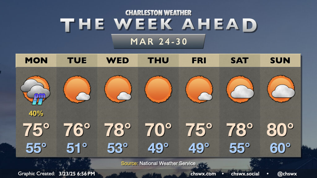
March will conclude on an unsettled and stormy note as a front moves through the area late Monday, bringing with it the risk for strong to severe thunderstorms as a squall line moves by in the late afternoon/early evening hours. It’ll be a very warm end to March, with highs peaking in the low 80s after a start in the low to mid-60s. There should be some breaks in the clouds, and with that, decent instability should develop. The shear is not off the charts, but with the instability and some pockets of drier air aloft, enough is there to support a scattered severe threat with damaging winds the primary concern. A tornado or two on the leading edge of the line can’t be totally ruled out, nor can some hail as well. Timing for thunderstorms is generally in the 4-8PM range from west to east across the metro, so be alert for potential issues during the commute. (The school day should be fine, though after-school stuff might get iffy if storms move a little faster than forecast.)
There’s not too terribly much to write home about (weather-wise, anyway) this first full week of astronomical Spring as a series of high pressure systems generally run the show. However, there will be a front approaching with enough moisture return ahead of it for some showers on Monday afternoon. We’ll start Monday in the mid-50s, warming to the mid-70s before showers arrive. Showers shouldn’t be terribly heavy, though a few rumbles of thunder aren’t out of the question with a little elevated instability around. No severe weather is expected, though.
The week ahead starts on an unsettled note, but turns fairly quiet for a few days with a warm stretch of weather featuring temperatures several degrees above normal.
The first full week of March will have a little of everything, from some frost and freeze to start followed by a round of springtime storms — a few of which could be severe — followed by another dip below normal. Monday starts with a Freeze Warning inland and a Frost Advisory closer to the coast as lows drop to around freezing across much of the area. We’ll warm back into the low 60s in the afternoon under generally partly cloudy to mostly sunny skies; this will still run a few degrees below normal for early March.
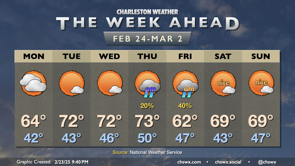
Climatological winter, which runs from December 1 to February 28 (or 29th, depending on the year) will end on a very spring-like note this week as temperatures head back above normal starting mid-week and beyond (with the exception of Friday, when a front comes by with a minor shot of cooler air).
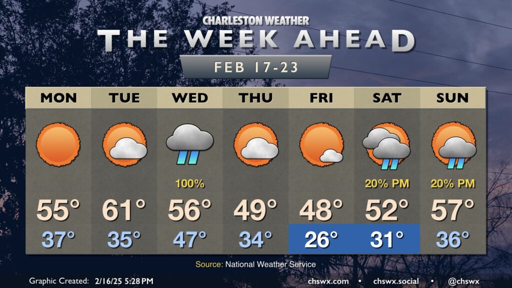
The week ahead will be notable for the return of cooler-than-normal temperatures to the forecast, especially after a mid-week storm system moves by which will send morning lows below freezing for the first time since the mid-January snowstorm.
After a record-breaking stretch of warmth over the past few days, we turn much cooler and cloudier for Monday as a backdoor front slides south and cooler high pressure wedges into the area in its wake. We could see some showers in the morning, but otherwise expect a mostly overcast day as lows in the mid-50s only warm a few degrees, perhaps not even cracking 60° in the afternoon. This stands in stark contrast to the record high of 84° set on Sunday, smashing the previous record for the date of 80° set in 1949. And while it’s been easy to forget with such warm weather, it is still February, and these things happen.
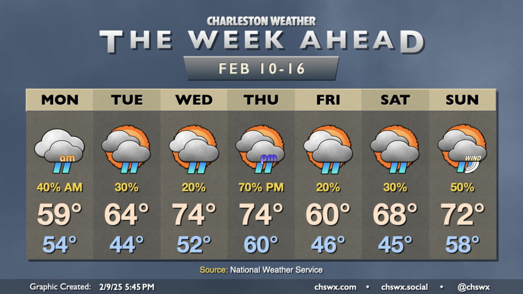
A mostly quiet week of weather lies ahead across the Tri-County area with high pressure aloft contributing to some of the warmest weather thus far in 2025.
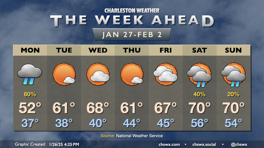
January will end much differently than how it has gone thus far as temperatures head around and even above normal to close out the month and bring in February with just a few rain chances mixed in to start and end the week.