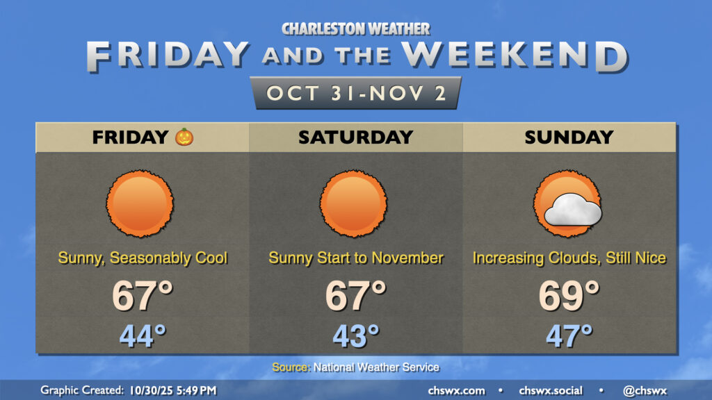
Halloween may be full of frights, but the weather won’t be one of them — seasonable and quiet weather is in store heading into Sunday with high pressure in control. Lows Friday bottom out in the mid-40s in the metro, with perhaps even lower temperatures further inland and in rural areas. We’ll warm to the mid-to-upper 60s in the afternoon with predominantly sunny skies and a gentle breeze out of the west. Saturday is essentially a carbon copy of Friday, though winds will be a little calmer and shifting direction out of the northeast and east. Don’t forget to set your clocks back an hour Saturday night as we fall back to Standard Time.
We’ll start to see dewpoints to climb back up and cloud cover begin to thicken as Sunday goes on in advance of the next storm system advancing out of the Gulf. Rain should hold off for the vast majority of the day, though a shower or two can’t be ruled out in the late evening. Temperatures on Sunday run a little warmer, with lows in the mid-to-upper 40s and highs approaching 70° despite the increasing cloud cover.
A cold front will swing through overnight, scouring out the clouds and ushering in drier high pressure behind it. It’ll be great to see the sun, which will make highs in the mid-60s feel quite nice. We’ll have a bit of a westerly breeze in the wake of the front, so keep that in mind if you have any plans to dine al fresco, but otherwise, it looks like a really good day of weather across the Lowcountry.
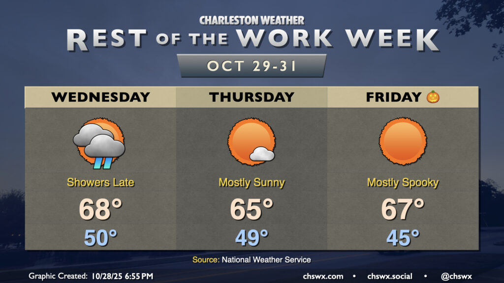
After the coolest day since late February — the high at the airport only peaked around 57° — we’ll turn warmer on Wednesday as an approaching cold front scours out the wedge of high pressure that brought us a dreary, drizzly Tuesday. We’ll start Hump Day around 50° under mostly cloudy skies once again. A warm front lifting northward will push through the area later in the afternoon, and it’s that warm front along with some breaks in the cloud cover which will help us warm to the mid-to-upper 60s later in the day. Shower chances will return in the evening through the overnight as a band of rain ahead of the cold front moves by.
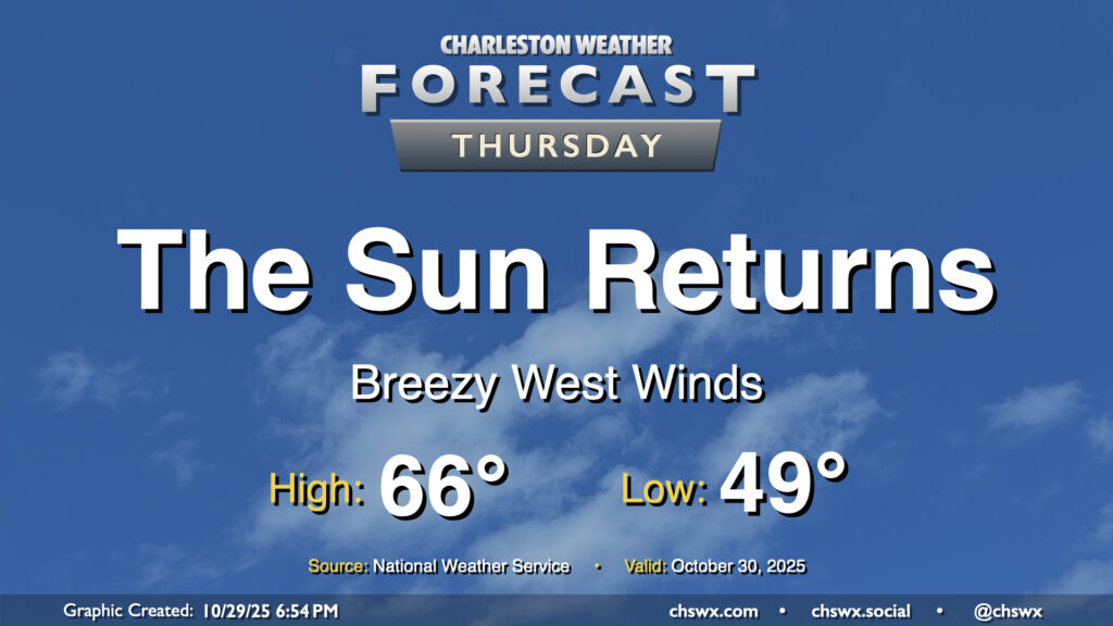
Showers should depart by the time most of us get Thursday underway. We’ll start in the upper 40s to around 50° once again, warming to the mid-60s in the afternoon with much more in the way of sunshine than we’ve seen so far this week. Clearer skies overnight Thursday will allow Halloween to start a little cooler, generally in the mid-40s in the metro (with lower temperatures possible further inland as well as in some more rural areas). Unfettered sunshine will send temperatures in the mid-to-upper 60s in the afternoon. Trick-or-treaters and their accompanying guardians (where applicable) should expect temperatures to fall into the 50s around and after sunset.
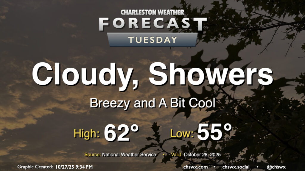
More overcast is in store for Tuesday despite low pressure departing the area. The overcast combined with gusty northerly winds and a few lingering showers will keep us on the cool side in the afternoon, with highs only peaking in the low 60s after a start to the day in the mid-50s. Showers should taper off by evening, with a rain-free period expected until Wednesday afternoon.
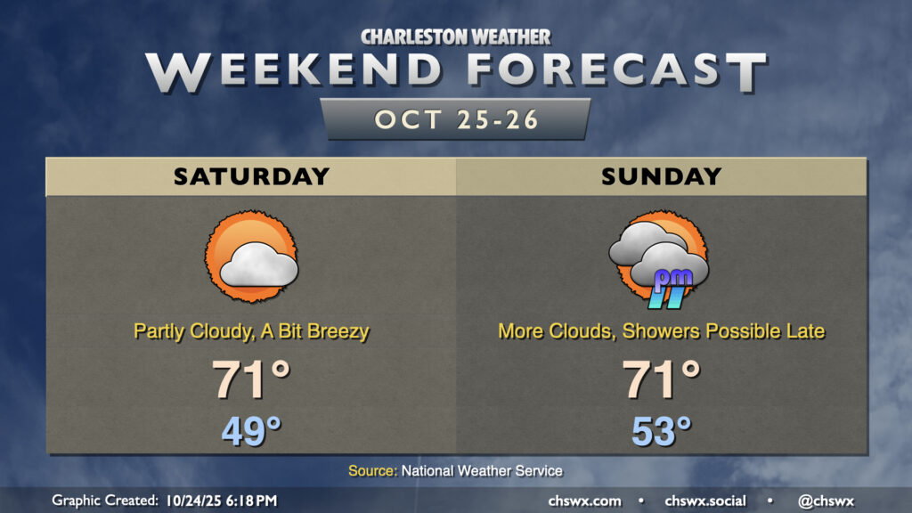
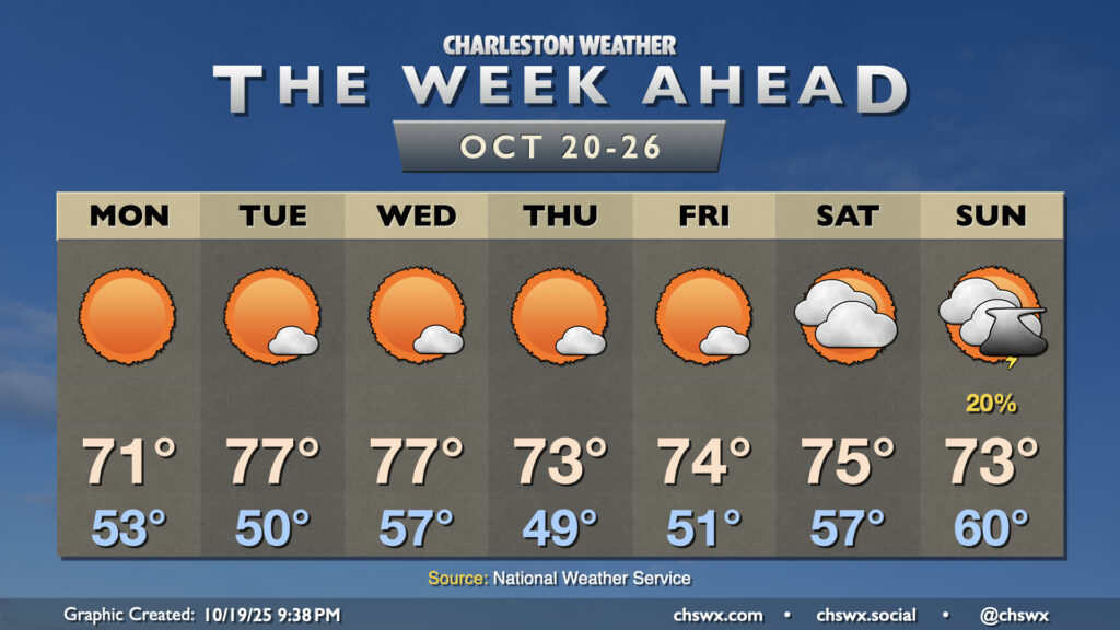
Generally speaking, we can expect good weather this weekend (especially on Saturday) with a wedge of high pressure building southward through the Carolinas into Georgia. This will lead to breezier conditions for the weekend as northeasterly winds kick up, and temperatures will run a couple clicks lower with cooler air moving in at the surface. Moisture will also start to overrun the wedge, and that will bring a gradual increase in dewpoints and cloud cover as low pressure develops in the Gulf. This low pressure system may bring us some showers later Sunday, and look to make for a soggy Monday.
Saturday’s lows will once again begin in the upper 40s (with some mid-40s inland), warming to the low 70s in the afternoon under partly cloudy skies. Cloud cover will continue to thicken on Sunday as moisture return continues; this will lead to a warmer start in the mid-50s before highs peak around 70-71° once again under mostly cloudy skies. Showers and maybe even some rumbles of thunder will be possible beginning Sunday evening, so keep that in mind as you make your weekend plans.
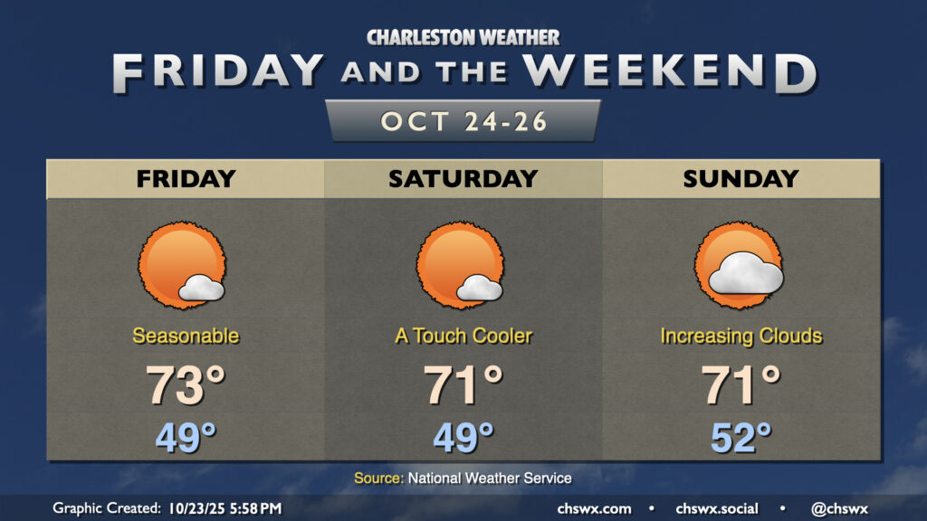
Expect generally quiet weather and seasonably cool temperatures to continue for Friday and the weekend. Dry high pressure remains in control for Friday with temperatures cooling to the upper 40s by morning, warming to the low-to-mid-70s in the afternoon with just a few clouds. High pressure then begins to wedge into the area over the weekend, bringing with it slightly cooler temperatures for Saturday. Moisture return ahead of the next storm system starts to kick in on Sunday, with dewpoints rising throughout the day contributing to a bit more in the way of cloud cover ahead of what looks to be an unsettled first half of the work week next week as low pressure heads up the coast.
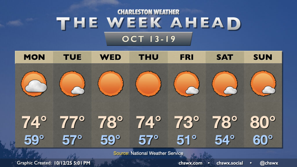
Another generally quiet week of weather lies ahead as high pressure remains the primary weather driver across the Southeast with a reinforcing shot of cooler air for the second half of the week.
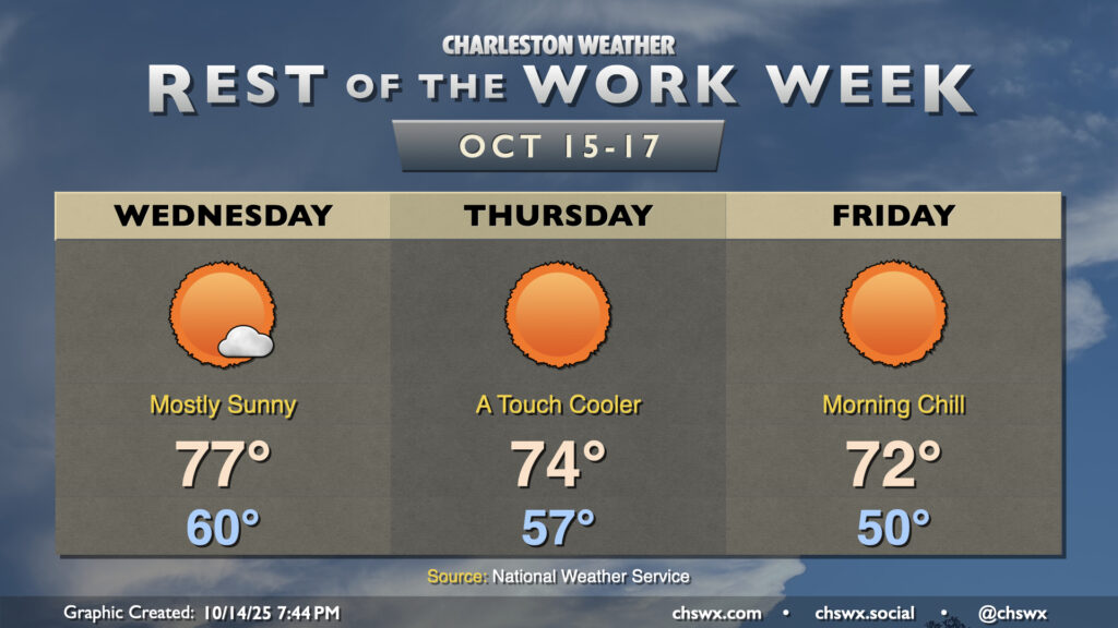
Pleasant weather continues for the rest of the work week as high pressure remains in control. A dry front will move through overnight Wednesday into early Thursday, bringing along a reinforcing shot of cooler and drier air that will make for a crisp start on Friday.
The nor’easter that has made for several soggy days across the metro will finally be pulling away on Monday, yielding a beautiful week of weather across the area with plenty of sun and comfortable temperatures.
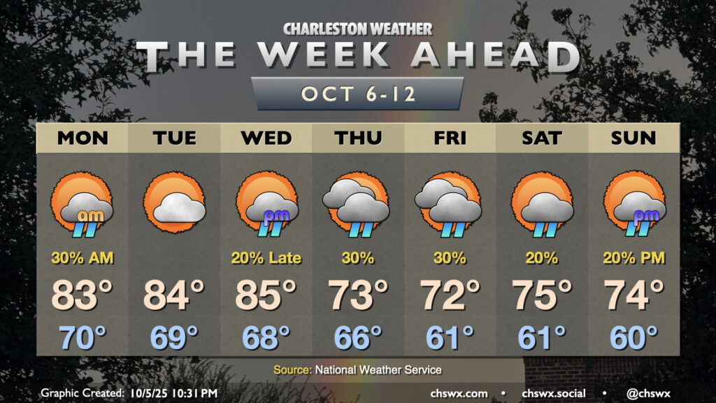
Warm temperatures will continue for the first half of the week before a cold front knocks temperatures down below normal starting Thursday. Shower chances will be with us for much of the week, though, and we’ll be dealing with coastal flooding as well.