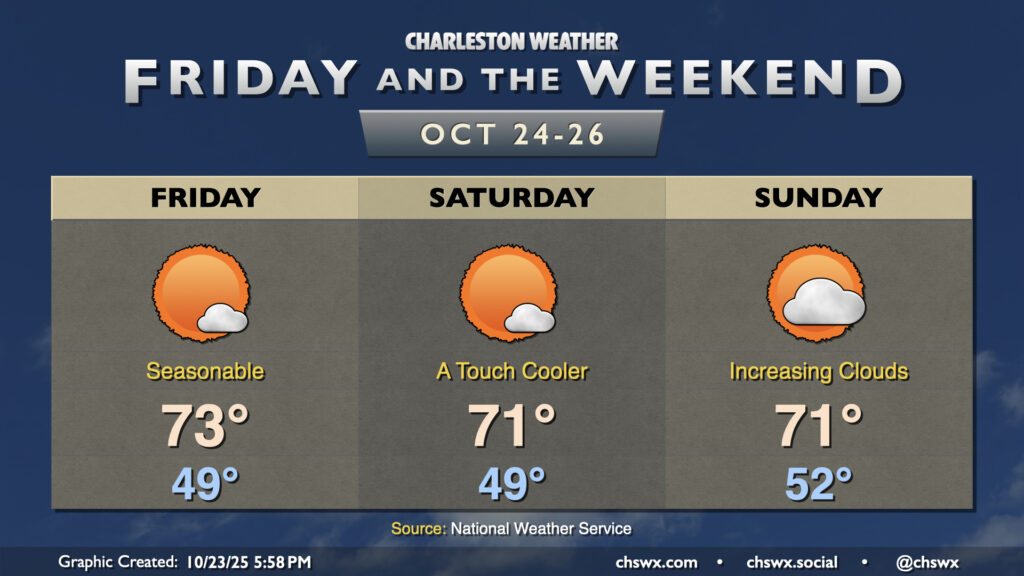
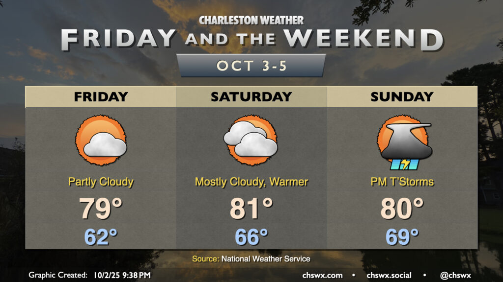
Expect generally quiet weather and seasonably cool temperatures to continue for Friday and the weekend. Dry high pressure remains in control for Friday with temperatures cooling to the upper 40s by morning, warming to the low-to-mid-70s in the afternoon with just a few clouds. High pressure then begins to wedge into the area over the weekend, bringing with it slightly cooler temperatures for Saturday. Moisture return ahead of the next storm system starts to kick in on Sunday, with dewpoints rising throughout the day contributing to a bit more in the way of cloud cover ahead of what looks to be an unsettled first half of the work week next week as low pressure heads up the coast.
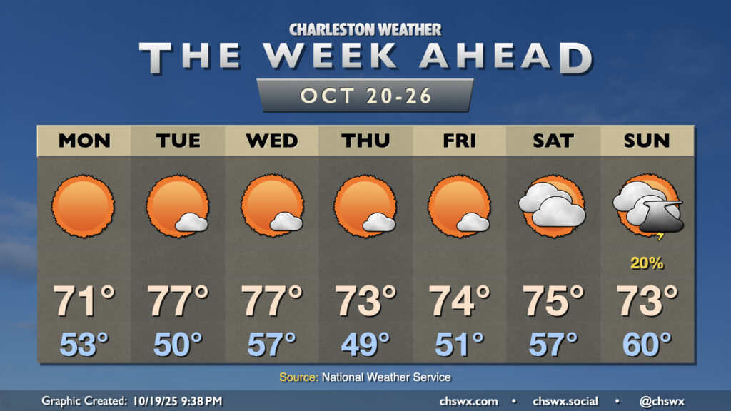
Another generally quiet week of weather lies ahead as high pressure remains the primary weather driver across the Southeast with a reinforcing shot of cooler air for the second half of the week.
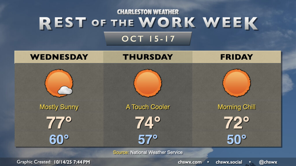
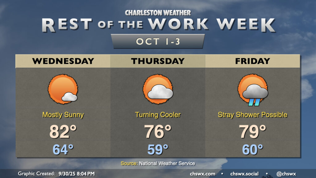
Pleasant weather continues for the rest of the work week as high pressure remains in control. A dry front will move through overnight Wednesday into early Thursday, bringing along a reinforcing shot of cooler and drier air that will make for a crisp start on Friday.
The nor’easter that has made for several soggy days across the metro will finally be pulling away on Monday, yielding a beautiful week of weather across the area with plenty of sun and comfortable temperatures.
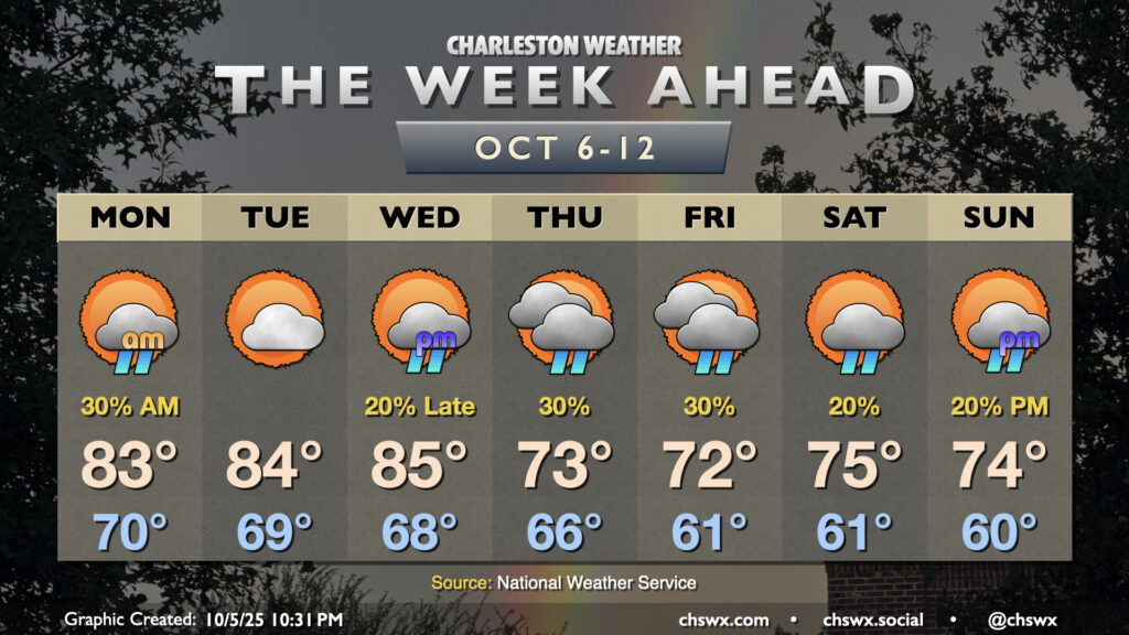
Warm temperatures will continue for the first half of the week before a cold front knocks temperatures down below normal starting Thursday. Shower chances will be with us for much of the week, though, and we’ll be dealing with coastal flooding as well.
Temperatures will continue to be generally seasonable if not slightly cooler than normal for Friday and the weekend as high pressure continues to wedge southward into the area, though we will see an uptick in moisture and, eventually, rain chances heading into Sunday.
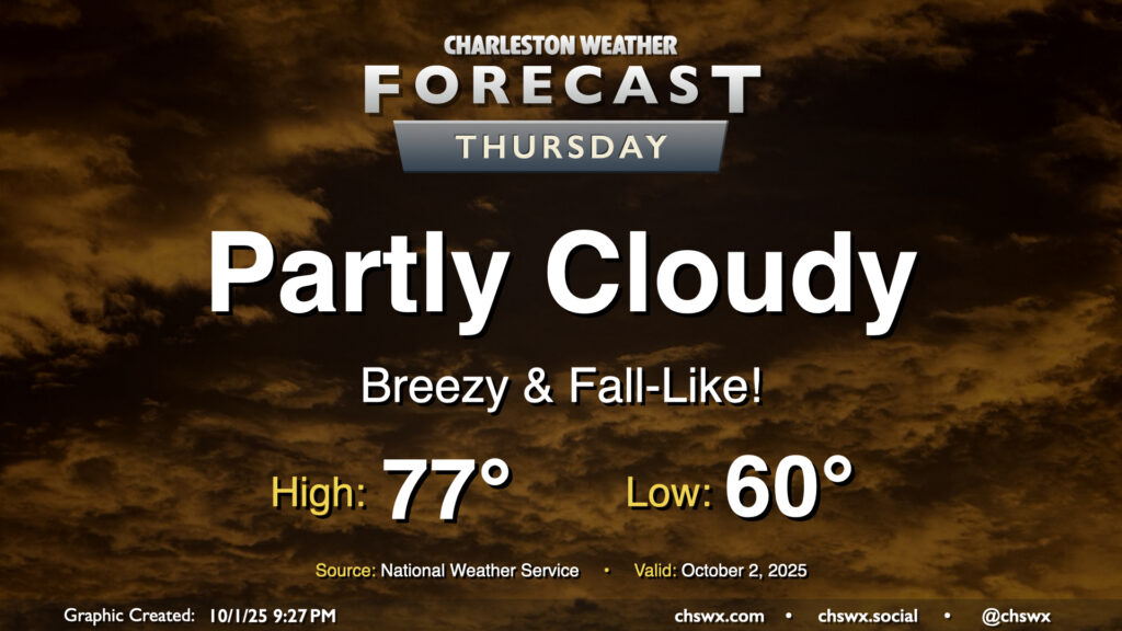
Thursday will give us a really nice taste of fall as cool high pressure wedges southward into the area. We’ll start the day with temperatures around 60°, warming to just the mid-70s under partly cloudy to mostly sunny skies. The northeasterly breeze will still be somewhat elevated, which may contribute to some minor tidal flooding around the 4:45 PM high tide. Otherwise, it’ll be an enjoyable day to get outside and touch some grass.
With Imelda departing to our east, high pressure will wedge down across the area, ushering in some cooler and drier air that’ll be particularly noticeable on Thursday. Shower chances return for Friday heading into the weekend, though.
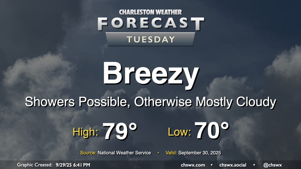
The pressure gradient between high pressure to the north and Imelda to the southeast will be tightening on Tuesday, and we should have a fairly breezy and seasonably cool day once again thanks to those northeast winds as well as cloud cover and a few lingering showers. Temperatures start around 70°, but should only warm to the upper 70s to maybe 80° depending on breaks in the clouds. The decaying coastal front will still be able to contribute to a few showers, but we should see shower chances diminish as we get through Tuesday and Imelda pulls further and further offshore.
There’s a chance that we could see some minor tidal flooding Tuesday afternoon courtesy of elevated water levels due to the onshore, northeasterly flow. The better chances for coastal flooding will begin Wednesday, though, and may be with us for a little bit as we head toward a full moon next week.
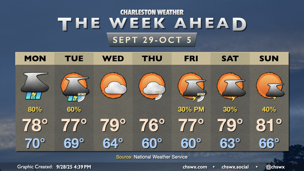
We’ll close September on a stormy note as moisture from Tropical Storm Imelda interacts with a stalled front/trough situated along the coast to produce solid shower and thunderstorm chances through Tuesday. From there, a good shot of fall welcomes us to October before more shower and storm chances return for Friday and the weekend.