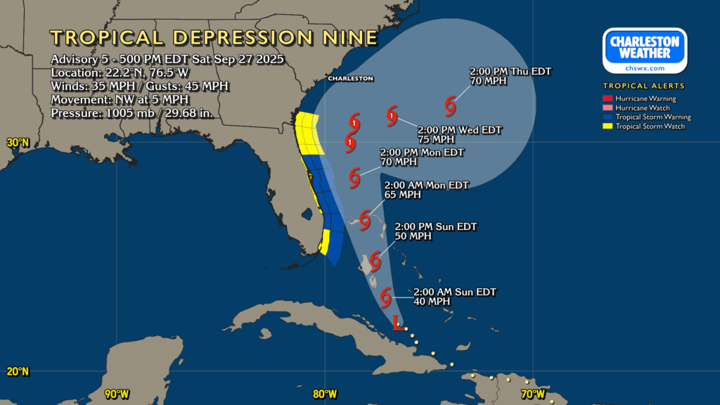
Tropical Depression Nine continues to organize, moving NW at 5 MPH on approach to the Bahamas, where Tropical Storm Warnings are in effect. Nine is still expected to strengthen, becoming a tropical storm tonight or early tomorrow morning. The next name on the list is Imelda.
On the current forecast from the National Hurricane Center, future Imelda will continue to move north-northwest heading into Monday, gradually strengthening into a hurricane (albeit a low-end Category 1). From there, it will stall out somewhere off the GA/SC coast Monday night into Tuesday, meandering until Humberto — a category 5 beast well out in the central Atlantic — gets close enough to help weaken the blocking high pressure to the north and “pulls” presumed Imelda eastward, away from the continental US.
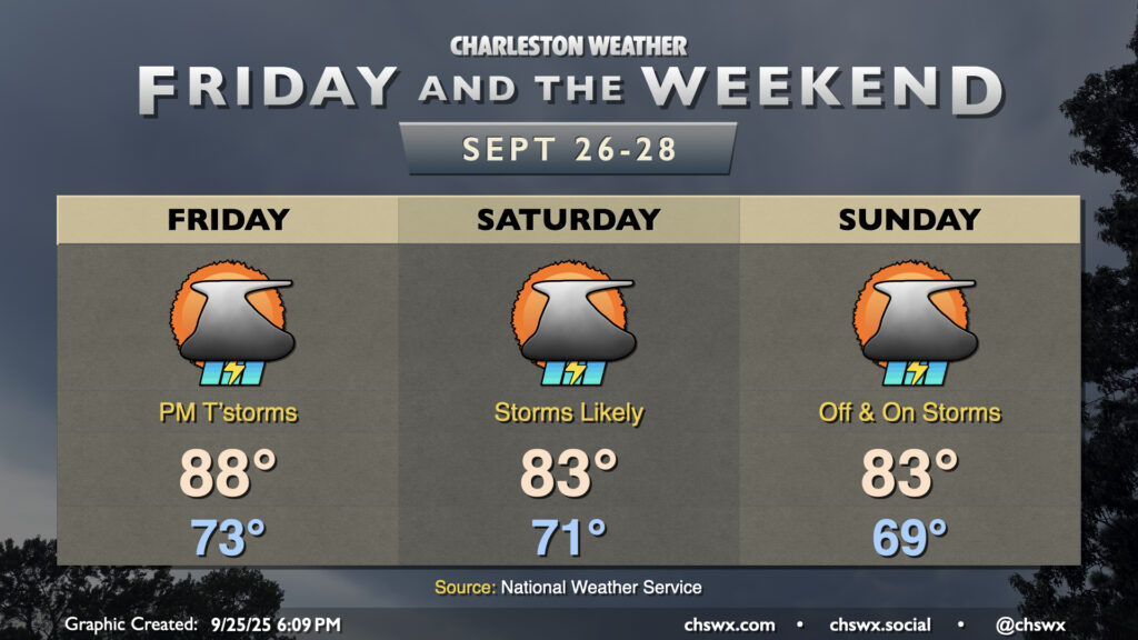
A front and upper-level low will send weather downhill as we get into Friday afternoon and the rest of the weekend, though that won’t be the main weather story, methinks, as we monitor the disturbance currently known as Invest 94L in the tropics for possible development and subsequent impacts next week.
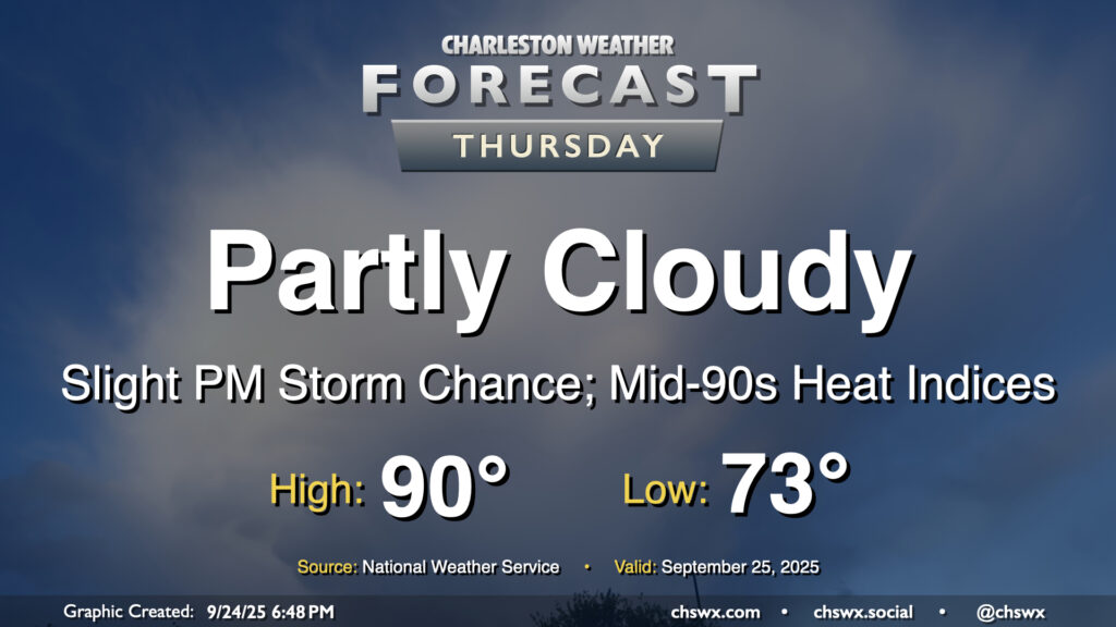
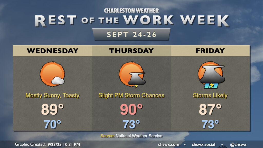
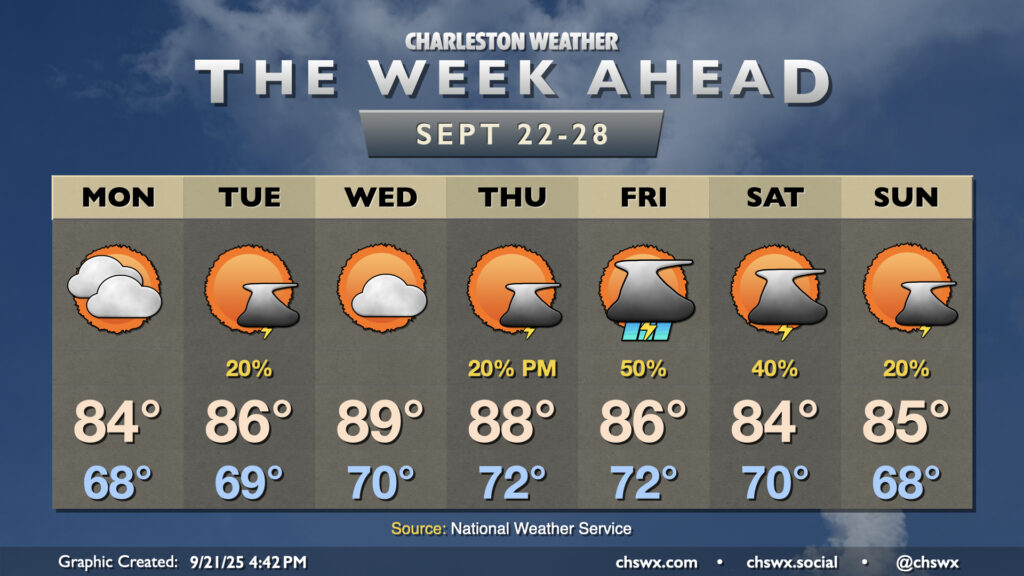
After hitting 91° on Wednesday, we look to take another trip to the 90s on Thursday as ridging aloft combines with Atlantic high pressure to keep us well on the warm side of normal for another day. Temperatures start in the low to mid-70s, well above normal for this point in the year, warming to the 90s in the afternoon with heat indices making it feel more like the mid-90s. We could see a stray shower or thunderstorm in the afternoon and evening along and ahead of the seabreeze, but most of us should stay dry.
Warmer-than-normal temperatures will persist for the next few days, especially ahead of a cold front that will bring some fairly solid rain chances to the area for the first time in a little while on Friday.
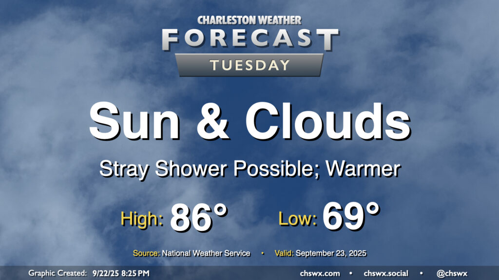
A warming trend begins Tuesday as high pressure to the north continues to weaken and winds turn more onshore, ushering in a much more summer-like feel over the next few days. Temperatures Tuesday start in the upper 60s to around 70°, warming to the mid-80s in the afternoon with a mix of sun and clouds. Factor in the upper 60s-lower 70s dewpoints and it’ll feel more like 90°. Like we saw on Monday, a few afternoon showers are possible, though the weakening high also will portend a weakening coastal trough, which should keep the risk for showers relatively low.
Astronomical fall begins on Monday with the autumnal equinox at 2:19 PM, but it will increasingly feel more like summer as the week wears on as above-normal temperatures take hold by midweek.
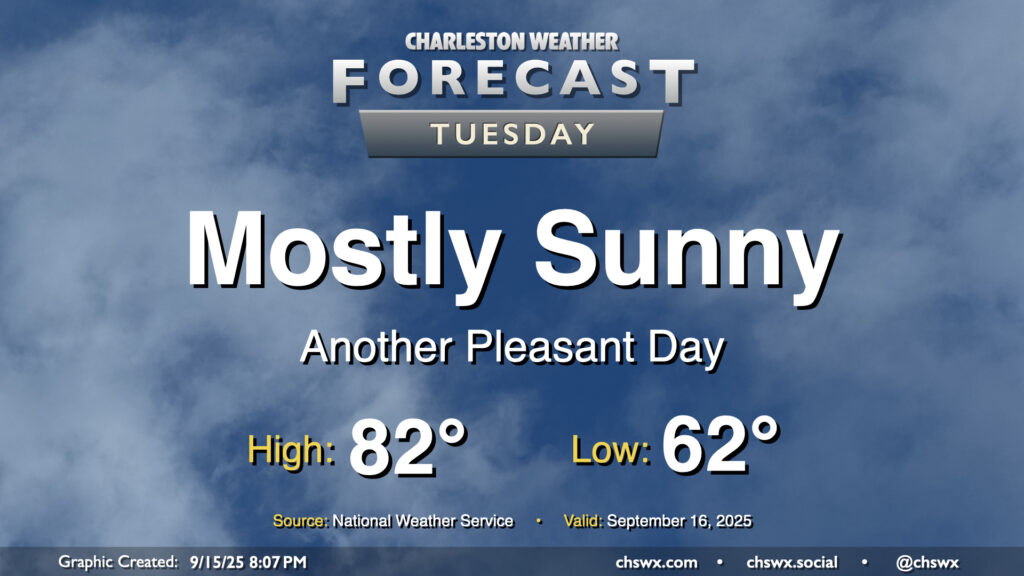
There’s not too much to write home about weather-wise for Tuesday other than it will be a really nice mid-September day across the Lowcountry. Below-normal temperatures continue, with lows in the low 60s warming to the low 80s in the afternoon under mostly sunny skies. Dewpoints mix down to the mid-50s in the afternoon, making the warmth comfortable. Plus, water levels will fall short of flood stage Tuesday as we get further away from the full moon and the recent perigee, so there are no coastal flooding concerns for the rest of the week, either.
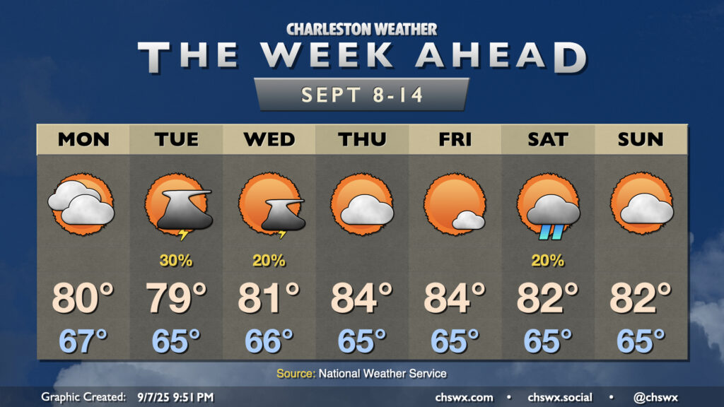
The week ahead will remain generally quiet, but we’ll start to turn warmer later this week as high pressure ridges in aloft. Slight shower and storm chances return to the area for the weekend, particularly on Sunday.
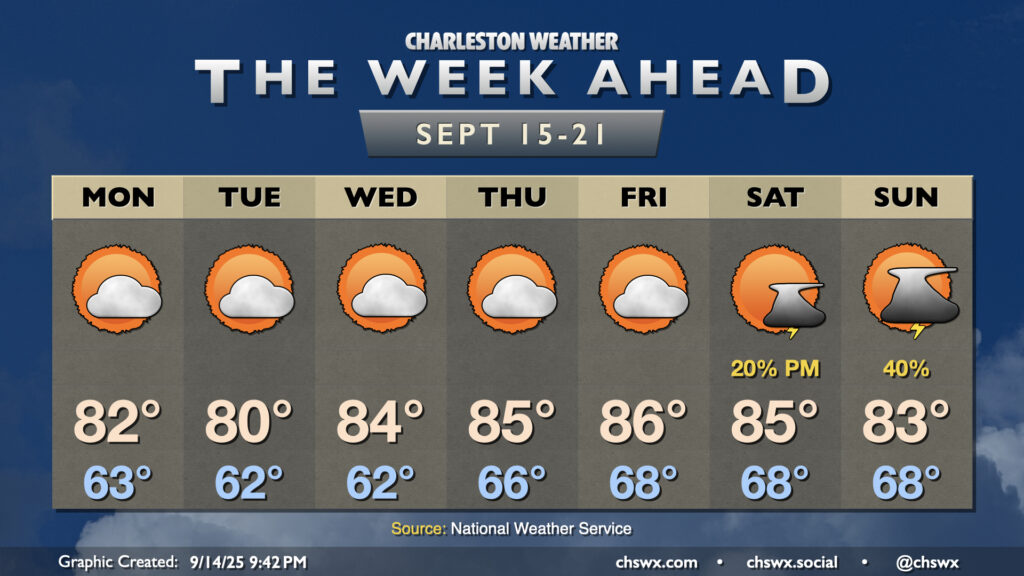
A front which helped stir up another round of heavy rain and flooding in downtown Charleston on Sunday will clear the area overnight into early Monday, yielding a week of comfortable temperatures with occasional slight shower and storm chances.
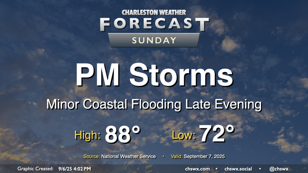
After a few welcome rain-free days, shower and storm chances return to the forecast for Sunday as a cold front moves into the area. We’ll start the day in the low 70s, working our way into the upper 80s in the afternoon before showers and storms kick off. Some rain could be heavy at times, and lightning may be an issue particularly inland where some stronger storms may be possible. It won’t be an all-day rainout, thankfully, but you’ll want to have your indoor plans ready to go if thunderstorms approach.
Isolated salt water flooding may also be a concern around the 7:47 PM high tide. The current total water level forecast brings the tide right to around 7′, which may be enough to cause a little flooding on the most vulnerable roads in downtown Charleston. The risk for coastal flooding around times of high tide increase throughout the first part of the week with the combination of the full moon, lunar perigee, and northeasterly winds in the wake of Sunday’s front, so stay tuned for Coastal Flood Advisories from the National Weather Service.