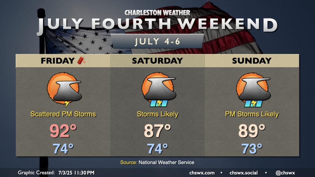
The weather for the Fourth of July weekend looks a bit on the unsettled side as low pressure — perhaps tropical in nature — spins up offshore and increases the risk for rain near the coast.
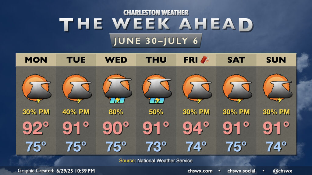
Independence Day itself looks okay with a bit of drier air working into the area in the wake of a stalling front. There’s still enough juice for a few thunderstorms along and ahead of the seabreeze in the afternoon, so be sure you have indoor alternatives to your outdoor plans just in case thunderstorms threaten. Temperatures start in the mid-70s, warming to the low 90s in the afternoon. Heat indices will run in the mid-90s to around 100° in the afternoon, particularly in the immediate wake of the seabreeze, so be wary of the heat especially if you are more vulnerable to it.
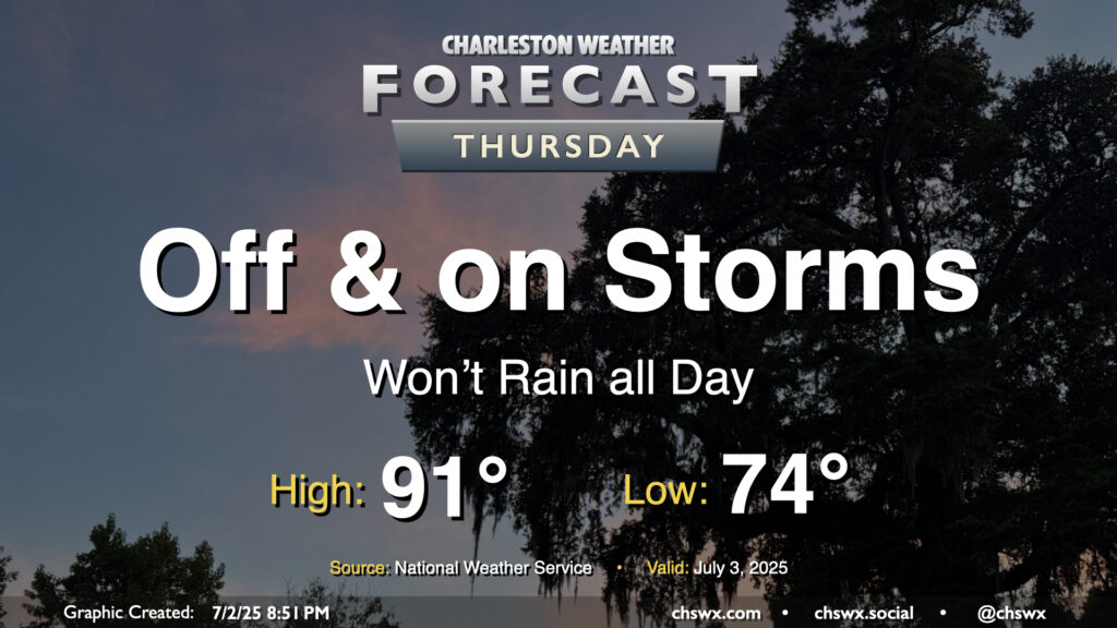
While storms so far on Wednesday were more off than on, more chances for rain arrive on Thursday with the heating of the day and a stalling front that will be in the neighborhood. Temperatures start in the mid-70s, warming to the low 90s in the afternoon — right on the line for what to expect from early July. Showers and thunderstorms will be capable of heavy rain and frequent lightning, and an isolated severe storm can never be ruled out this time of year where boundaries collide.
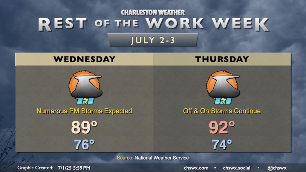
A cold front will draw nearer to the Lowcountry on Wednesday before stalling out, which will help kick up the risk for thunderstorms especially during the afternoon and evening hours. It won’t rain all day, but many of us should measure some rainfall as storms push across the area from west to east through late night. Temperatures in the mid-70s will warm to the upper 80s to around 90°. There’s a chance our 18-day streak of 90°+ highs will come to an end thanks to the proliferation of cloud cover, showers, and thunderstorms on Wednesday, but we will see. Regardless, expect a steamy and eventually stormy day across the metro; be ready for rain to cause some slowdowns.
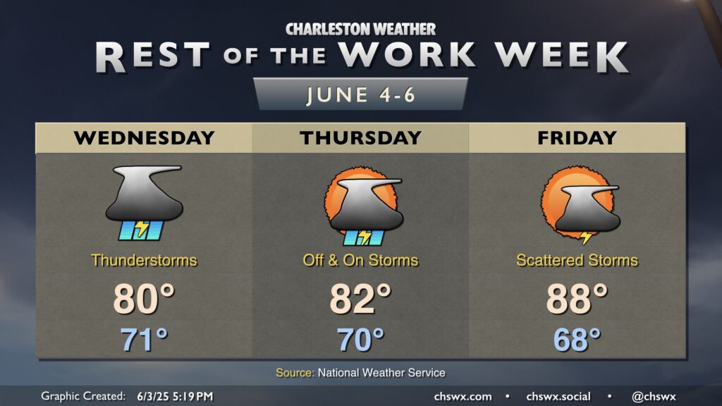
Thursday is looking a little better, though some storms could linger midday. But drier air will be moving in, and we should see improving conditions by evening. It’ll be another warm day, with highs returning to the 90s in the afternoon after another mid-70s start.
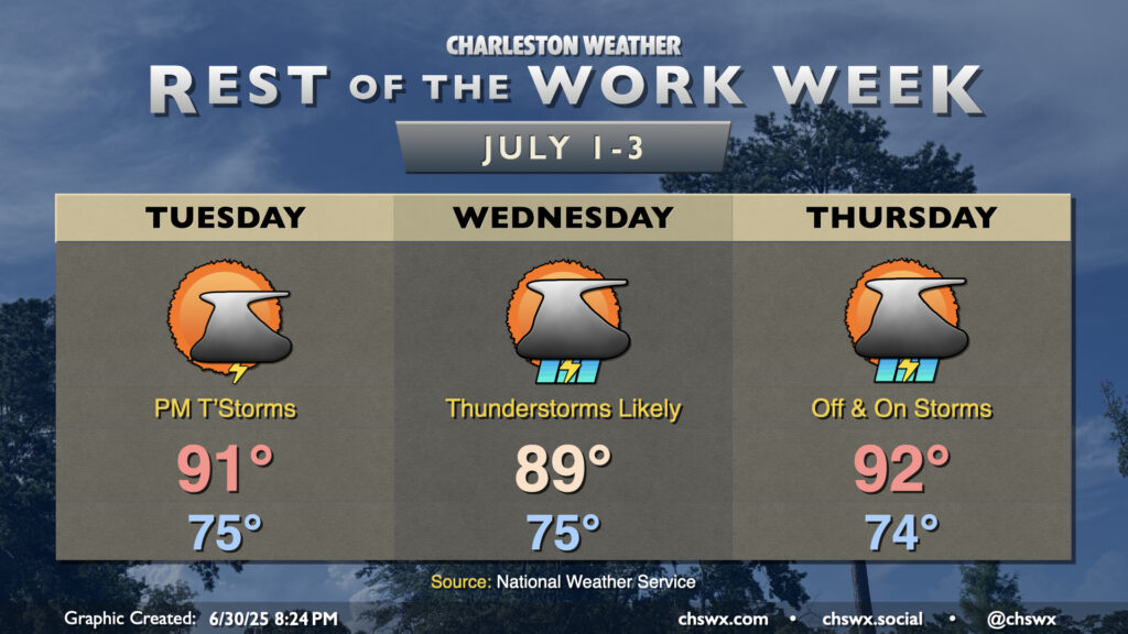
The rest of the work week will turn increasingly stormy as a cold front encroaches on the area by midweek. A trough aloft will help drive the front close to the area — but not quite through — and contribute to an influx in lift and moisture that’ll bring us scattered to numerous thunderstorms, particularly on Wednesday.
Warm, humid, and occasionally stormy days lie ahead to close out June and bring in July. (Side note: It’s insane that we’re entering the second half of 2025!) Temperatures look to remain in the 90s each afternoon, and if the forecast works out, the current 16-day streak of 90°+ high temperatures should continue through a third and into a fourth week (23 days, to be exact).
A cold front will approach the area on Wednesday into Thursday, stalling out before it reaches us (of course). This will increase the risk for showers and thunderstorms for those two days in particular, and if there’s a period that could impact that 90° streak, this is it. Regardless, it’ll still be steamy and stormy.
A coastal low will bring numerous showers and thunderstorms, some with potentially heavy rain, to the Lowcountry starting late tonight and peaking Wednesday into Thursday.
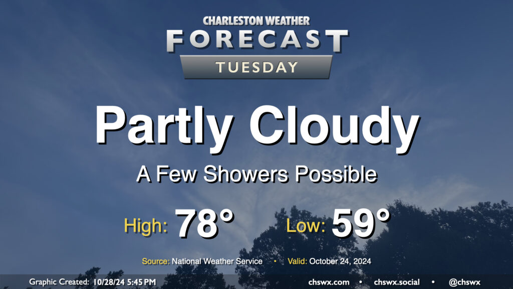
A surface trough will push inland Tuesday, and this could spread a few showers ashore throughout the day. Rain chances are pretty small, though, given the continued dry conditions, and any rain that does fall probably will not amount to a whole heck of a lot. Rain chances diminish by evening. Otherwise, expect partly cloudy skies. Temperatures will begin to trend back above normal, with upper 50s in the morning yielding to highs in the upper 70s in the afternoon.
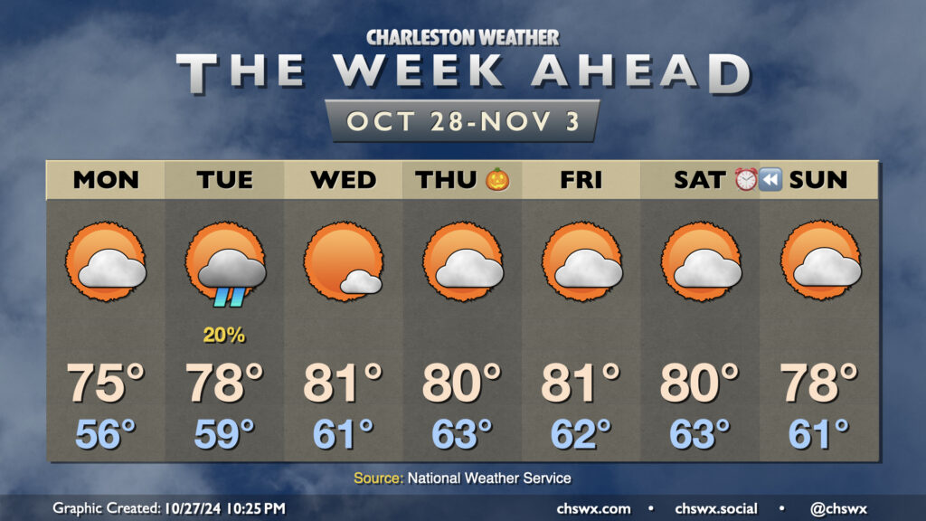
A cool wedge of high pressure knocked temperatures down into the 60s on Sunday afternoon, but we should see temperatures begin to recover starting Monday, with above-normal temperatures favored for much of the upcoming week.
Cloud cover will scour out throughout the day Monday as ridging builds back in aloft. We’ll still be under the influence of the cool wedge of high pressure, which will keep highs right around the normal mark of 75° for late October after a mid-50s start.
Rain chances remain essentially nil this week, save for Tuesday, when a coastal trough could spread some light showers ashore. Much of us should stay dry, with measurable rainfall not looking like a great bet given the antecedent dry conditions. Highs on Tuesday head a few degrees above normal, back into the upper 70s after an upper 50s start.
The weather remains dry and much warmer than normal as we close October and start November. Expect highs in the 80s each afternoon starting Wednesday through at least Saturday with seasonably mild starts in the low 60s each morning as high pressure continues to be the primary weather feature. Skies will generally be partly cloudy each day. Suffice to say, we’ve got no weather concerns for trick-or-treaters this year. A front slips by over the weekend with a slight cooldown, but moisture appears to remain at a premium, keeping rain chances virtually nil.
Finally, we fall back to Standard Time this weekend. The morning daylight will be a little more in whack with sunrises before 7am until late November, but we’re back to “dark when we leave work” season once again. We’ll go from a 6:27 PM sunset on Saturday to a 5:26 PM sunset on Sunday. We continue to lose daylight until the winter solstice on December 21.
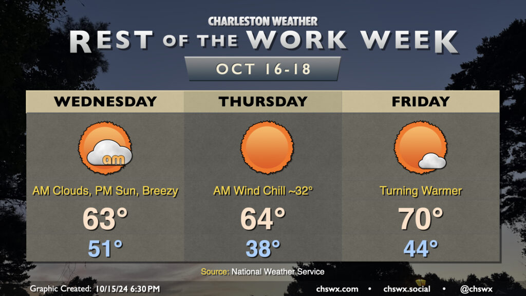
A reinforcing cold front will swing through overnight tonight, ushering in the coldest air so far this season. We’ll start the day in the low 50s, but gusty north winds will cause temperatures to struggle to the low 60s despite increasing sunshine as clouds from the frontal passage dissipate. This certainly qualifies for sweater weather in our neck of the woods — have the warm clothes at the ready!
Thursday morning will be the coldest of the set as the cool air continues to push into the area, though winds will diminish a little. Temperatures in much of the metro could dip into the upper 30s to around 40° — quite possibly the coldest morning since February 22, when it was 37°. The wind chill will be a factor (pun somewhat intended), and could make it feel close to freezing. A couple layers aren’t the worst idea heading out the door in the morning. Despite full sunshine, temperatures will still only recover to the mid-60s at best in the afternoon. This is well below normal for this point in the year (think upper 70s), and may flirt with record cold high temperatures as well (62° set in 1970).
Temperatures start to bend back toward climatology on Friday, though. We’ll start the day in the mid-40s as a bit more of an onshore component to the wind develops, heading to about 70° in the afternoon under sunny skies once again. As we get into the weekend, temperatures will continue to run a bit below normal, but mid-70s will mean short sleeves are back on the menu. With plenty of sunshine, it’ll be a solid weekend of San Diego-like weather (if you know, you know).
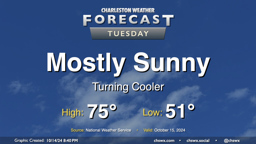
Tuesday’s temperatures, despite plenty of sunshine, will run a little below normal for this point in October. We start the day in the low 50s, warming to the mid-70s in the afternoon. Clouds will be hard to come by, though they should begin to increase after midnight. That being said, it should be another solid evening of stargazing in the western sky as Comet Tsuchinshan–ATLAS continues to appear in the night sky after sunset.