2018, reviewed: A relatively quiet severe weather year
Source: Iowa Environmental Mesonet
2018 was highly irregular in one fairly beneficial way: There was an overall lack of severe weather (at least as far as tornadoes, straight-line damaging winds, and hail go) during the year.
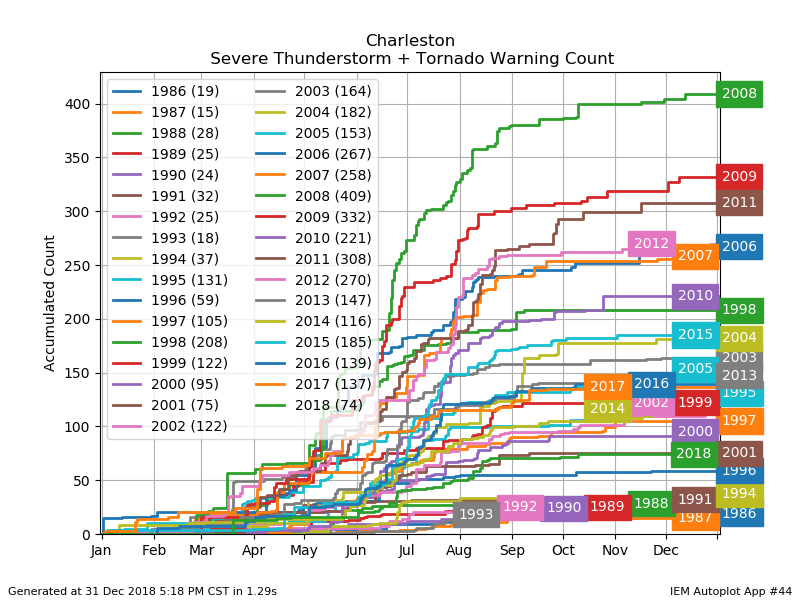
The National Weather Service in Charleston issued only 74 tornado or severe thunderstorm warnings in all of 2018. This is the lowest warning count since storm-based warnings replaced county-based warnings in October 2007, and the lowest warning count since 2001 when the office only issued 75 tornado or severe thunderstorm warnings. (Note: NWS Charleston serves both Southeast South Carolina and Southeast Georgia, including Savannah, and these numbers include those areas.)
Why so few warnings?
One likely factor is that the science and available tooling continues to improve, allowing for better warning performance. According to Iowa Environmental Mesonet’s “Cow” verification tool, NWS Charleston (unofficially) verified 56.8% of its warnings in 2018. (A “verified” warning is a warning which received at least one severe weather report.) This was up from 54% in 2017, when the office issued 137 warnings and verified 74 of them. This also helped to drive the false alarm rate down to 43% from 46% a year earlier.
The other factor, though, is that there just wasn’t as much severe weather. Across the NWS Charleston county warning area, there were only 168 preliminary severe weather reports, whereas in 2017 there were 239 of them, and 320 of them in 2016.
One possible cause of so few severe reports: Persistently strong subtropical ridging, which put a lid on afternoon thunderstorms becoming too terribly strong and getting further organized in many cases. (Said ridging also kept us persistently very, very warm this summer.) Additionally, we didn’t get mesoscale convective complexes paying us a visit as they sometimes do, particularly in late summer. These complexes can bring organized damaging wind events to the area. They just didn’t materialize.
(Note: I’m using preliminary storm report data because the vetted storm report database, Storm Data, is unavailable at the time of publication due to the partial government shutdown. Preliminary storm reports are not de-duplicated and have only undergone very basic vetting. The shutdown is also having impacts on my ability to reliably produce charts to illustrate upper-air features which may have helped put the kibosh on severe storms. When the shutdown ends, I’ll be able to provide much more context. Watch this space.)
The August 9 Severe Event
Right panel: Velocity data. Images generated with Unidata’s fork of AWIPS II.
A dearth of severe weather doesn’t necessarily mean there was no severe weather, though. On August 9, a cluster of thunderstorms moved through the Tri-County area, bringing down several trees and power lines, including a tree on a house on Daniel Island.
Weather stations around the area recorded gusts routinely over 40 MPH, including a 52 MPH gust at Ft. Sumter according to WeatherFlow data.
The storm also produced a significant amount of lightning, making for some rather spectacular (if not dangerous) photography. True to form, @chswx followers captured and tweeted numerous images of the light show. (Note: @chswx does not endorse putting yourself in danger for the sake of lightning photography.)
Of this event, the National Weather Service wrote in its event summary:
“This was the most active severe weather event since September 11, 2017 (Tropical Storm Irma) and the most active extra-tropical severe weather episode since July 2, 2015.”
National Weather Service, Charleston, SC Weather Forecast Office
It remains to be seen what 2019 holds as far as severe weather goes, but the relative respite from severe events during the summer of 2018 was most welcome.