Looking ahead: Jumping aboard the Pneumonia Express

Buckle up: We’ve got quite a temperature rollercoaster (and an unsettled pattern in general) headed our way over the next couple weeks.
Friday

Source: NWS Weather Prediction Center
After showers scour out early in the day on Friday, temperatures will rebound very well into the mid-60s ahead of our next approaching storm system. Skies will feature a mix of clouds and sun, but additional rain should hold off until Saturday rolls around.
Saturday
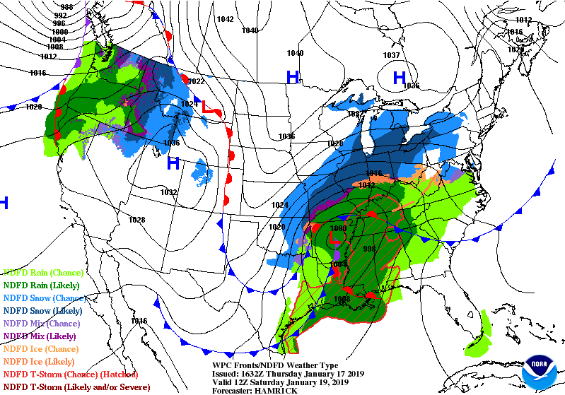
Source: NWS Weather Prediction Center
Saturday is the pick day of the weekend. Above-normal temperatures will continue; there is the potential we could get close to 70° in some spots! Rain should hold off for much of the day, though recent model guidance suggests potential for a shower or two in the morning inland from the coast. Will want to watch this trend to see if rain chances are warranted for inland locations earlier in the day. Otherwise, we should remain in pretty good shape through sunset before the onset of rainfall around midnight-2am.
Watching Saturday Morning’s High Tide
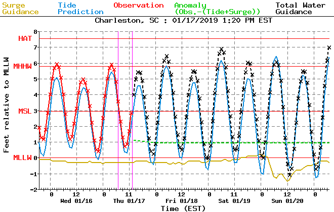
Source: NWS Meteorological Development Laboratory
We’ll be keeping an eye on tides early Saturday morning. Thanks to onshore winds and influences from the full moon, there will be the potential for the 5:59am high tide to get close to 7′, which would mean some minor salt water flooding around that time. Fortunately, we should be rain-free around that time, but we’ll want to monitor the details closely.
Sunday

Sunday will start out warm and a bit stormy as the initial cold front comes through the area. Rainfall amounts should generally be around a half-inch or so in most spots, with locally higher amounts to an inch possible. Rain chances will begin to decrease in the afternoon, with some clearing likely before the sun goes down.
This will be another day where we set our high temperature relatively early in the day as a steady dose of Arctic air will knock temperatures down as the afternoon progresses. There’s still some fine-tuning as far as hourly temperatures go, but be ready to dress warmly as temperatures drop well into the 50s.
I’ve gotten a couple questions about snow this week; rest assured, there is no winter weather in the forecast as the cold air we would need will lag behind the moisture by almost a day.
Total Lunar Eclipse: ~9:30 PM Sunday – 2:45 AM Monday
Beginning late Sunday evening through very early Monday morning, we’ll be able to see the only total lunar eclipse (“Super Blood Wolf Moon”, because apparently we name eclipses like metal bands now) of 2019. The eclipse starts a little after 9:30 PM, peaking just after midnight with full totality. The eclipse will come to an end just after 2:45 AM.
Sky conditions will be steadily improving as Sunday evening progresses. While a few clouds will likely be in the area, they should not be enough to spoil viewing of the eclipse. The bigger weather problem is going to be whether you want to stand out in the cold for it — wind chills should be getting well into the 30s around midnight as Arctic air rushes in.
Overall, expect pretty good viewing conditions — just be ready to bundle up!
Monday-Wednesday
After the cold front swings through on Sunday, we will be getting quite cold as our first real taste of Arctic air makes its appearance. High pressure will steadily build into the area, putting Monday’s expected temperatures on par with the coldest air of the season thus far. NWS has maintained highs in the mid-40s, but it wouldn’t shock me to see those nudge a little bit lower.
It’s also worth noting that wind chill values could drop into the teens on Monday morning. This will be something to keep an eye on; if the forecast heads close to wind chills around 15°, a Wind Chill Advisory may be needed.
Tuesday morning looks to once again be below freezing, but expect temperatures to moderate to the mid-50s as Arctic high pressure quickly slips away ahead of yet another storm system. By Wednesday, we’re talking rain chances and 60s again before another sharp cooldown for the subsequent weekend.
Looking Toward February
The NWS Climate Prediction Center favors cooler than normal weather to continue as we close January and head into February. Bottom line: Winter is indeed coming, and may have some staying power.