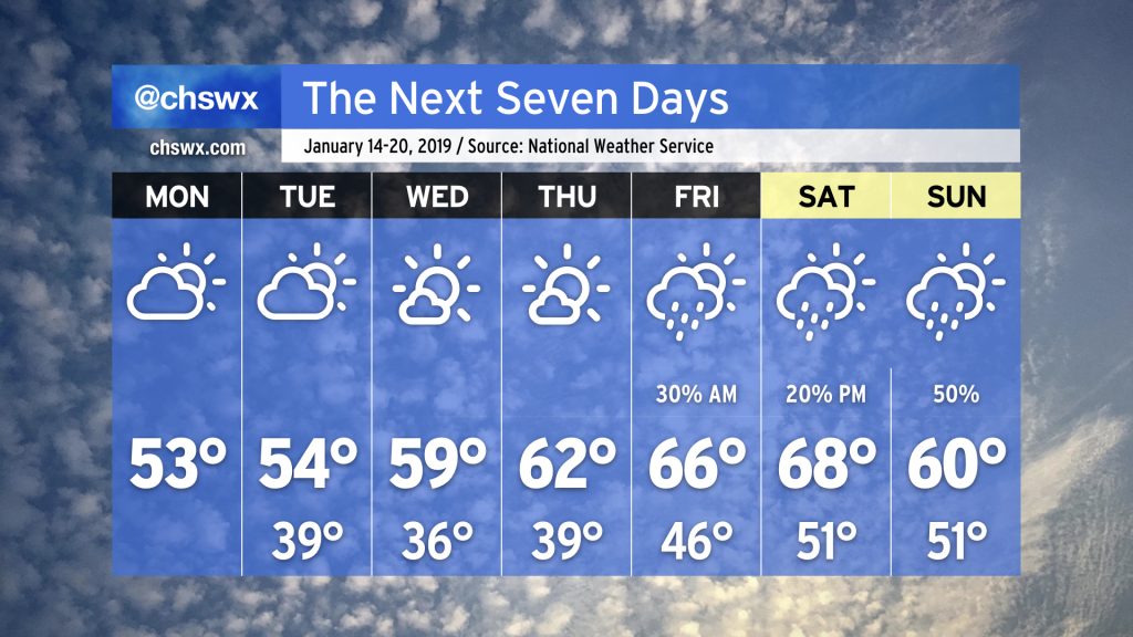
The week ahead: January 14-20
The latter half of January looks to usher in a more unsettled pattern that seems reminiscent of December, at least in its timing: Unsettled weekends followed by mostly dry (and occasionally chilly) work weeks. Indeed, that’s how this week looks to go down.
Quiet — but cloudy — start to the work week
We start the work week on a cool and cloudy note. Moisture trapped not far off the surface will keep partly to mostly cloudy skies in place through Tuesday, with peeks of sun. Temperatures will behave accordingly by staying in the low-to-mid-50s, which is a few degrees below normal for this time of year. (Conversely, the cloud cover will also help to keep temperatures above freezing overnight.)
It may look gloomy at times Monday and Tuesday, but rain is not expected as the moisture layer is pretty shallow — too shallow for any precipitation to develop.
Mid-week: Sun peeks out, we warm up
By mid-week, high pressure will move just about overhead, helping to scour out the remaining moisture and bring us mostly sunny skies for Wednesday and Thursday. Wednesday looks to be the coolest morning this week — think mid-30s — but temperatures will begin to moderate as high pressure shifts overhead and then to our east. We may touch 60° on Wednesday, and should be in the low 60s by Thursday afternoon.
Late week: A couple storm systems bring an unsettled end to the week
Note: Late week details are subject to change. Always check the latest forecast data before making (or canceling) plans!
By Friday, the upper-air pattern becomes a little more amplified, sending an upper disturbance toward our neck of the woods. This will help drive a storm system across the Appalachians; its trailing cold front may generate some showers early Friday as it passes by to the north.
Said front will be generally weak and doesn’t look to have much impact on temperatures as we should achieve the mid-60s as a little ridging aloft in the wake of the said upper disturbance will help keep us a little on the warm side.
Saturday looks mostly quiet until late in the day, when shower chances increase ahead of a more potent storm system that arrives in the area Sunday. Timing is key and thus tough to pin down at this range, but be monitoring Sunday closely for the potential for some heavy rain showers at times, especially early in the day.
Temperatures look to plummet during the day on Sunday as a cold front passes by. (The depicted high in the 7-day forecast for Sunday will likely be achieved early in the day!) This front should usher in much colder weather for the following week (January 20-26), but that will be another post when we get out of model voodoo land. 🙂