Today’s showers and tomorrow’s chill

We’ve got some rain headed our way this afternoon into early this evening, followed by another round of chilly temperatures. Temperatures look to bounce back to close out the work week, though.
Showers for the evening commute

This morning, we find rain mixed with some snow moving through portions of TN, AL, and MS. This activity is along and ahead of an Arctic cold front, which will spread a reinforcing dose of winter well into the Southeast as today goes on.

Source: NWS Weather Prediction Center
The wintry weather will not make it this far east, as temperatures will warm into the low 60s this afternoon ahead of the front and freezing temperatures lag the moisture by 6-8 hours or so. Overall, expect a fairly warm day after a start in the upper 30s to low 40s.

In general, showers look to arrive for the evening commute (roughly 4-8 PM based on NWS forecasts and recent high-resolution model output). Rainfall amounts will generally be on the light side, but any rain at the evening commute can cause issues, especially in isolated heavier downpours. Be ready to allow a little extra time to get home tonight.
Once the front and its attendant line of showers comes through, temperatures will quickly back off into the low 50s, falling to about freezing for Wednesday morning. Make sure pets and human loved ones have a warm spot to be tonight!
Brief chill with a warmup to close the work week
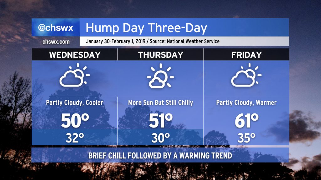
Once the front gets through, we will chill out well below normal for Wednesday and Thursday, though not quite the Arctic chill that our friends in the upper Midwest and Northeast will feel. (-22° in Chicago? HARD PASS.) By Friday, temperatures begin to rebound a bit as winds turn more onshore and the core of the cold airmass passes by.
Overall, the rest of the week looks fairly quiet from a weather perspective with a good mix of sun and clouds and no rainfall to speak of until possibly late Sunday. Signs are that our warming trend continues into early next week, too, so bundle up and hang in there!