The week ahead: Abnormal February warmth
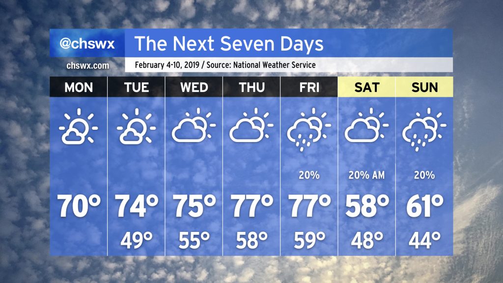
Warm weather fans are going to like what is in store for the upcoming work week as subtropical ridging takes shape over the Gulf of Mexico, driving the storm track and cooler air to our north for a few days.

What’s up with the warmth?
This morning, we find ourselves within a deep layer of dry air in the wake of an impressive cyclone spinning up off the coast of North Carolina. The radar appearance sure is interesting, but largely harmless as the low heads away from the US.
This layer of dry air combined with ridging aloft in the wake of the upper low will allow temperatures to rise to the low 70s in many spots away from the immediate coast today under mostly sunny skies. (We stay a little cooler there thanks to 53° water temperatures in the harbor.)

The upper-air pattern will become increasingly amplified this week as a trough digs into the western U.S., spreading cold and unsettled conditions there while ridging builds north from the Gulf of Mexico, generally allowing for quiet and warmer-than-normal conditions here in our part of the Southeast. With a Bermuda high at the surface keeping southerly winds in place, warm air will continue to make inroads, and we may challenge record highs by the end of this week.
Watch for sea fog
Sea fog may also become a concern starting possibly as early as tonight into Tuesday as warm southerly winds move across chilly shelf waters. Mariners will certainly want to watch for this possibility, and it is conceivable that sea fog may come ashore at times as well, making for hazardous driving conditions.
Clouds and a cooldown for the weekend

As we get closer to the weekend, the aforementioned trough in the west will head northeastward. This will have the effect of suppressing the high aloft a little further southward, allowing a cold frontal passage late Friday. This frontal passage looks dry right now, with limited moisture return, but a chance of showers is in the weather picture for Friday afternoon and evening.
Behind the front, temperatures will cool off into the upper 50s and low 60s for the weekend. A “wedge” of high pressure looks to drive southward into the area; northeast flow within the wedge will drive in cooler air off the Atlantic. Aloft, some slugs of moisture will contribute cloud cover from time to time.
As with all seven-day forecasts, this is subject to change, so please check back for updates.
Will this last?
Despite what a certain groundhog may say, indications are that the pattern will flip back to a somewhat more normal El Niño regime as we get into the second half of the month. Cold snaps will certainly be possible, and while it may be tempting this week, you should really avoid trying to get ahead on your planting unless you really know what you are doing — it’s just another #FakeSpring.