One last dry day before rain returns

Today, we’ll enjoy one more dry day with a bit more warm air before rain chances re-enter the weather picture overnight into Wednesday.

This morning we find some light returns on the radar out of Columbia (our radar is out of service for a few days while important upgrades are being made). However, it appears based on surface observations that these returns are not reaching the ground. Examining this morning’s weather balloon shows a significant amount of dry air in place from just off the surface to just shy of 16,000 feet.
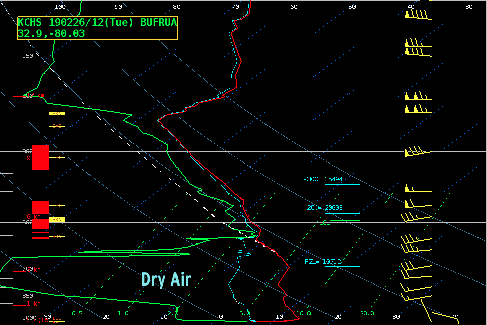
Any precipitation falling through that layer of dry air is just not going to have much of a chance to reach the ground at all. This will change, though, as low-level moisture return improves later today into tonight with high pressure moving offshore.
Rain chances for the rest of the week, then a cooldown

A series of disturbances will be swinging through this week, bringing periodic rain chances. We could see up to an inch of rain in spots over the next few days, which would be good as rainfall is running below normal — in fact, we are back in the abnormally dry category in the Drought Monitor. A strong disturbance will drive a front into the area on Saturday, bringing with it a sharp cooldown to well-below-normal temperatures, but rain chances look to continue. The pattern is complex and bears watching; as always, check back frequently as the weekend forecast is still evolving.
I’m watching the middle of next week closely for the potential for a freeze — keep this in mind if you are beginning to plant. Speaking of…
NWS Frost and Freeze Warning program resumes March 1
The National Weather Service in Charleston will resume its frost and freeze warning program on March 1, signifying the beginning of the growing season. The median last freeze date at the airport is March 8. Further inland around Moncks Corner, you’ll want to wait until mid-March at least to start planting.
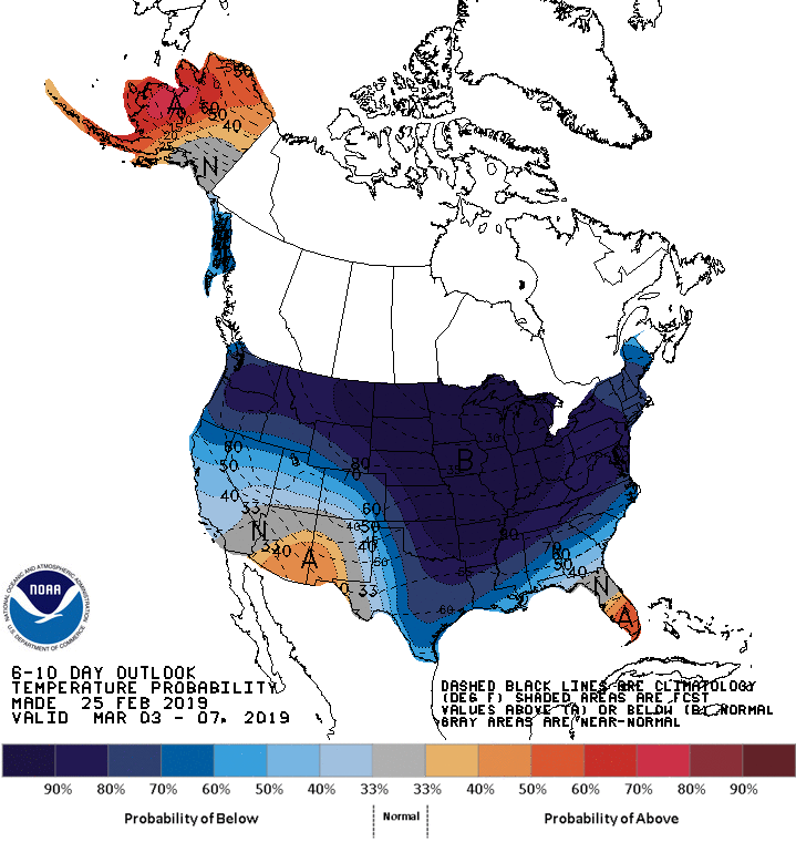
As mentioned earlier, ensemble guidance for the middle to end of next week indicates a decent shot at a freeze for much of SC. The Climate Prediction Center is on board with high probabilities of below-normal temperatures across much of the East as the Arctic looks to open up for business one more time. Stay tuned…
Vote @chswx for Best Local Twitter Feed!

The Charleston City Paper’s Best of Charleston voting is open again, and thanks to your nominations, I am a finalist for Best Local Twitter Feed. If you like what I am doing with @chswx, I would be honored by your vote. Voting is open from now until midnight Thursday, March 5th.
As always, thanks to you for your support — especially those of you who are patrons! It is hard to believe that @chswx is entering its 12th year this year, and it remains very, very true that I cannot do this without you.