Much-needed rain on the way

Today marks the beginning of an unsettled period for the Lowcountry, as rain chances will remain with us for much of the next seven days. This will be some much needed rain, though, as we are running a little behind for the year thus far.

Scattered showers for Wednesday
This morning we find showers coming in off the Atlantic with a few embedded downpours. These will shunt eastward with time as a disturbance comes through the Gulf Coast of Florida, skirting off to our south. We’ll see showers come to an end later this evening with some clearing expected to develop.
Highs will run well above late February normals in the low 70s today and for the next few days.
We need the rain
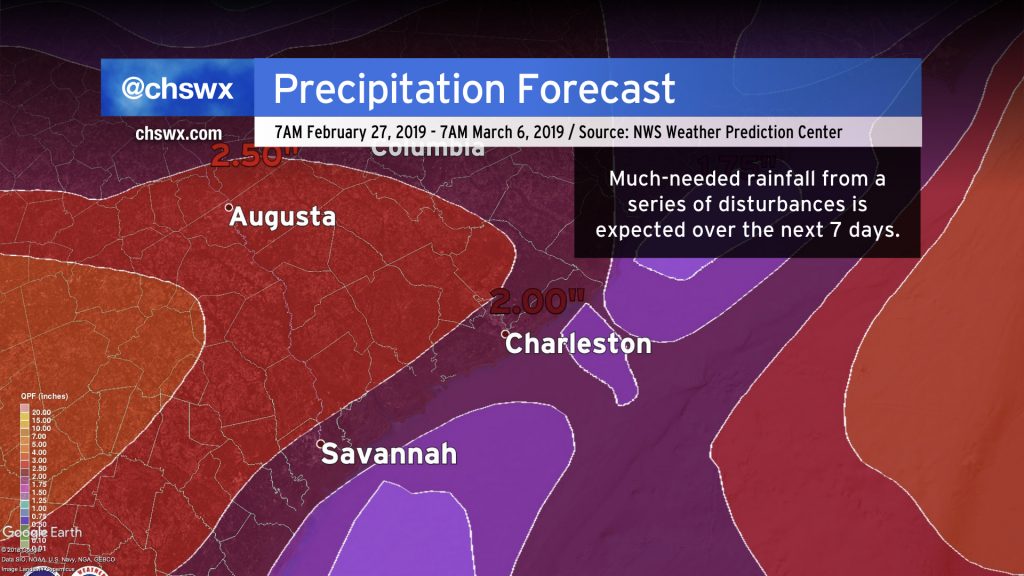
So far this year, we are running a little over 4″ behind in the rainfall department (4.11″ at the airport, to be exact). This is enough for last week’s drought monitor to reflect abnormally dry conditions in the Lowcountry (next update comes tomorrow).
A series of disturbances this week will assist in putting a decent dent into that deficit, with rain totals over the next few days anywhere from 1.5-2.5″ with locally higher amounts. Flooding is not expected to be a concern as it’s not going to fall all at once, soils aren’t terribly saturated, and tides will remain below coastal flooding thresholds.
Cooldown coming for next week

As the weather remains unsettled over the next seven days, we will see above-normal temperatures flip to much cooler readings as we get into the new work week. Chilly high pressure looks to build in after Tuesday, which may drive temperatures into frost and freeze territory this time next week. As always, the devil is in the details, but keep in mind that we aren’t done with cold weather just yet. The average last freeze date at the airport is March 8. For those of you further inland, the average last freeze date is as late as March 25. All this to say: Beware of the temptation of #FakeSpring!
Tonight on Carolina Weather Group

Tonight on Carolina Weather Group, the panel gets to know Mace Michaels, a meteorologist at WeatherNation who also does a lot of interesting side forecasting, including for the Minnesota Twins. It should be an interesting show, and I hope you can join us!
Carolina Weather Group streams live on Periscope, Facebook Live, and YouTube every Wednesday night around 8:15 PM Eastern. The podcast is generally available the day after recording wherever you get your podcasts, such as Stitcher, TuneIn Radio, or Apple Podcasts. Enjoy the show!
Vote @chswx for Best Local Twitter Feed!

The Charleston City Paper’s Best of Charleston voting is open again, and thanks to your nominations, I am a finalist for Best Local Twitter Feed. If you like what I am doing with @chswx, I would be honored by your vote. Voting is open from now until midnight Thursday, March 5th.
As always, thanks to you for your support — especially those of you who are patrons! It is hard to believe that @chswx is entering its 12th year this year, and it remains very, very true that I cannot do this without you.