Here comes the heat wave

High pressure is aligning at the surface and aloft to bring us quite the early-season heat wave starting tomorrow, featuring a run at the all-time warmest May day on record and little to no rain for many of us.
Records in jeopardy
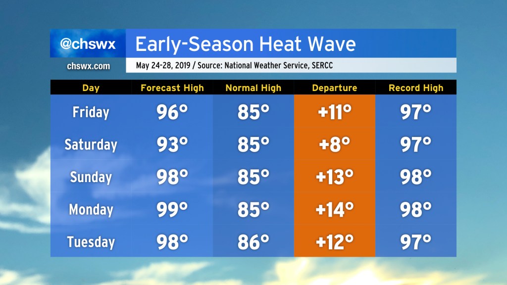
The record book may see some revision, particularly Sunday-Tuesday of next week, as a strong ridge of high pressure combines with downslope flow from the northwest to toast the Tri-County area. With the seabreeze pinned to the coast, temperatures will get very warm all the way to the beaches.
The record I’m watching most closely: the all-time warmest May day on record, 99° on May 21, 1938. It looks very conceivable that Monday could tie that record. There are several days of 98° in the forecast, as well, which would also join rare air — there are only other three years where a day in May has topped out at 98°: 1938, 1953, and 1989. So, while this heat isn’t necessarily without precedent, it is still very much on the high end of the scale of what we typically see this time of year.
As air temperatures rise into the upper 90s, we will see heat indices climb into the low 100s. Northwest flow will help mix out the dewpoints some, keeping the worst heat indices at bay, but it will still become dangerously hot.
Records at Charleston International Airport’s climate site go back to 1938.
Heat safety
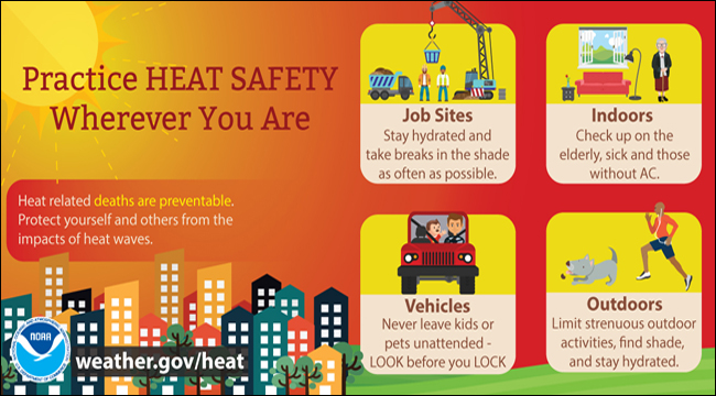
Heat safety precautions are going to become necessary for at least a week (if not longer). Here are some tips to make sure you and your loved ones weather the heat well:
- Ensure your air conditioning unit is in working condition. Be sure to keep your filter changed at regular intervals to keep it working efficiently!
- Make sure your elderly or sick loved ones and neighbors are doing well. They are particularly vulnerable to very hot weather.
- If at all possible, stay indoors during the heat of the afternoon. Delay outdoor activities until evening, if you can.
- If you must be outside, seek plenty of shade, take frequent breaks, and drink lots of water. (Sorry, y’all, beer’s not going to cut it.)
- Look before you lock. Pets and children can quickly succumb to extreme temperatures in hot cars. In 2018, South Carolina was the top state for hot car deaths involving children. Let’s try not to repeat that performance!
Drought continues

As the hot weather goes, so goes the drought. There is just not much of a chance of rain with such strong high pressure in place. One notable exception may be Saturday as a decaying front moves into the region from the north, perhaps acting as a focal point for showers and thunderstorms. We will see if this can bring some relief, but for now, we remain solidly entrenched in moderate drought with rainfall deficits running well above 7″. Dry soils will only act as a feedback mechanism for the hot weather, too. Suffice to say, we really, really could use the rain.
Reader question: Driest May on record
The driest May on record at the airport was in 1941, when only .27″ of rain was measured for the month. May of 2000 was exceptionally dry downtown, when only 0.02″ of rain was measured.
Putting this May in perspective depends on the climate site you are at. A downpour earlier this week at the airport brought May 2019 down to merely the 14th driest on record there with 1.39″ recorded thus far. It’s a different story downtown, though, where 0.26″ of rain so far this month is good for fourth driest all-time. (Records at downtown Charleston date back to 1893.)
Bottom line
- A prolonged heat wave is expected to begin Friday through perhaps the first week of June.
- Rainfall will be tough to come by; drought continues.
- Take heat safety precautions and be sure to check on vulnerable populations.
- Look before you lock!
Follow my Charleston Weather updates on Mastodon, Bluesky, Instagram, Facebook, or directly in a feed reader. Do you like what you see here? Please consider supporting my independent, hype-averse weather journalism and become a supporter on Patreon for a broader look at all things #chswx!