Hot start to the second half of 2019

The second half of 2019 will get off to a fairly hot start, with heat indices running in the low 100s each afternoon. Scattered thunderstorms will provide relief, particularly later in the week. (Must be July in Charleston.)
Tidal flooding possible this week
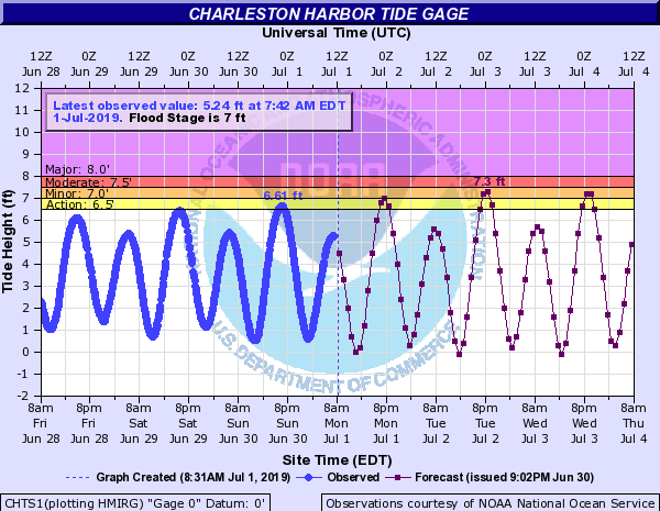
Thanks to the new moon at perigee (when the moon is closest to Earth in its orbit), we’ll see some tidal flooding with each evening high tide beginning tonight and lasting well into the rest of the week. More substantial flooding beyond the tide is not terribly likely as thunderstorm development will be driven by the heat of the day, and low tides will occur each afternoon. Still, it’ll be something to keep an eye on for those of you with plans this Fourth of July week.
Changes to heat advisory criteria start today
July 1 marks the beginning of higher heat advisory criteria for the rest of the year. Leading up to June, heat indices of 105° or over for a prolonged period of time (generally two hours) will trigger a Heat Advisory. After July 1, this criteria moves up to 110° as the 105° heat index would trigger advisories basically every day. Note that changing this criteria doesn’t necessarily mean that 105° heat indices become any less dangerous — heat illness is still very much an issue at that temperature. (In fact, we’re likely to have several days experiencing 105°+ heat indices this week.)
Tropical update: Nice and quiet
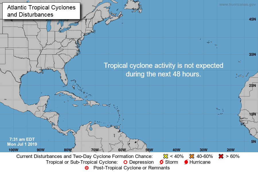
All is quiet in the tropics as we head into July thanks to large-scale sinking motion and a consistent plume of Saharan dust, which tropical systems really don’t like. If only it could stay this quiet all year! Unfortunately, we know things can ramp up rather quickly. Don’t let your guard down — we are only into the second month of the season, which tends to ramp up beginning in August.
In memoriam: Michael James
Over the weekend, Michael James, a developer at Unidata in Colorado who most recently worked on bringing the National Weather Service’s AWIPS system to the broader community, passed away after a paddle boarding accident.
To say this is a major loss to the weather community is an understatement. GEMPAK is a cornerstone of visualization in weather research, and AWIPS has brought NWS-grade weather analysis tools to geeks far and wide (like me!). AWIPS in particular has become a key part of my day-to-day weather monitoring toolkit. Michael will be missed tremendously by everyone in the weather community. My thoughts are with his family, friends, and colleagues.
Follow my Charleston Weather updates on Mastodon, Bluesky, Instagram, Facebook, or directly in a feed reader. Do you like what you see here? Please consider supporting my independent, hype-averse weather journalism and become a supporter on Patreon for a broader look at all things #chswx!