Dorian Advisory 38: Hurricane Watch, Storm Surge Watch now in effect

At the 5PM advisory (which came out about 20 minutes early — thanks, NHC!), Dorian was found to have totally stalled out just north of Grand Bahama Island, which continues to take a lashing from this Category 4 storm. An eyewall replacement cycle has caused the storm to lose some intensity, but it’s not much consolation when the storm still packs maximum sustained winds of 145 MPH. The storm is now completely stationary after showing some signs of a northward jog earlier in the day. Until we can see a more substantial turn, uncertainty around the specifics of Dorian’s track and impacts on our area remains rather high.
Watches issued
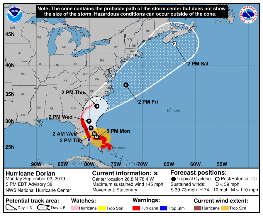
With the 5PM advisory, the National Hurricane Center has issued a Hurricane Watch up to South Santee River, which includes Charleston. A Hurricane Watch means hurricane conditions (winds 74 MPH or greater) are possible within 48 hours. The Hurricane Watch extends inland to Berkeley County as well.
A Tropical Storm Watch is now in effect for Dorchester County. Similar rules apply for a Tropical Storm Watch, except that expected wind speeds range from 39-73 MPH.

A Storm Surge Watch is also in effect as well along the coast and up parts of the Ashley and Cooper Rivers. 4-7′ of storm surge on top of predicted tides appears probable within the watch area, with the threat beginning Wednesday morning.
What this means: It’s time to start completing hurricane preparations now and have everything wrapped up by Tuesday evening. Weather will begin to head downhill by Wednesday morning. Once tropical storm-force winds reach the area, it will be too dangerous to try to continue any preparation.
What to do tomorrow
You’ll have one good day of preparation left before weather heads downhill on Wednesday. (See my post on potential impacts from this morning for more details.) Be sure to take time tomorrow to bring in loose items that may get blown around, inspect your property, and finalize any last-minute details. If you’re evacuating, tomorrow’s the day to do it. As I mentioned before, if you wait too much longer past Tuesday evening, it may be too late to drive safely.
Next update
The next full track and intensity forecast will arrive from NHC at 11 PM. I’ll have another blog shortly after it is out.
Follow my Charleston Weather updates on Mastodon, Bluesky, Instagram, Facebook, or directly in a feed reader. Do you like what you see here? Please consider supporting my independent, hype-averse weather journalism and become a supporter on Patreon for a broader look at all things #chswx!