Stationary Hurricane Dorian continues to devastate the Bahamas

Hurricane Dorian continues to sit stationary just north of Grand Bahama Island, lashing the island with its eyewall (as it has for much of the day). As the storm has remained stationary, it has weakened somewhat, but remains a dangerous Category 4 storm with maximum sustained winds of 130 MPH as of the 11 PM advisory.
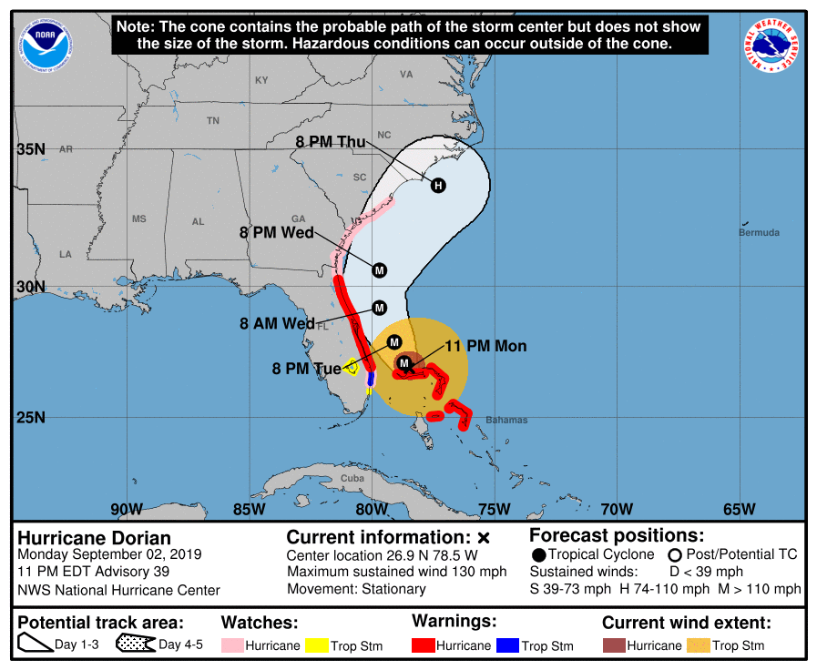
There are no significant changes as far as the track and intensity forecast with this advisory. To recap watches and warnings:
- A Hurricane Watch is in effect for Berkeley and Charleston counties
- A Tropical Storm Watch is in effect for Dorchester County
- A Storm Surge Watch is in effect for the coastline as well as the peninsula
Model guidance continues to indicate the beginning of a northward turn during the day Tuesday. There is excellent agreement in this scenario; a vast majority of guidance members are now keeping the storm’s center over water. This is good! However, we are going to need to continue to watch wobbles in the track, as a few miles can make a big difference as far as impacts.
I expect that warnings will be hoisted at some point tomorrow, perhaps as early as the 5am advisory. When those are issued, that is your signal to bring preparation to an end and hunker down as deteriorating weather is expected to begin within the next 24 hours. Timing for the worst weather for Charleston remains roughly Wednesday morning through Thursday evening. We should be able to finalize this timing tomorrow, especially after the bloody storm starts moving again.
More in the morning.
Follow my Charleston Weather updates on Mastodon, Bluesky, Instagram, Facebook, or directly in a feed reader. Do you like what you see here? Please consider supporting my independent, hype-averse weather journalism and become a supporter on Patreon for a broader look at all things #chswx!