Advisory 41: Hurricane Warning in effect
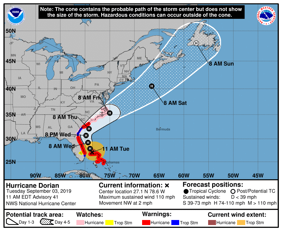
Advisory 41 on Dorian is in, and it is now a category 2 storm on the Saffir-Simpson wind scale with maximum sustained winds of 110 MPH. The storm is now moving northwest at 2 MPH, and is expected to make a turn more to the north sometime tomorrow, paralleling the coastline.
Recapping active alerts:
- A Hurricane Warning is in effect for Charleston and Berkeley Counties.
- A Storm Surge Warning is in effect for Charleston and tidal Berkeley counties.
- A Tropical Storm Warning is in effect for Dorchester County.
- A Flash Flood Watch will be in effect from Wednesday morning to Friday morning.
What to do now
With a Hurricane Warning in effect, now is the time to finish preparations and, if ordered to do so, evacuate. Conditions are still expected to head downhill during the day Wednesday, so be sure you have everything pretty well nailed down by tonight. Bring in loose items, ensure your belongings are secure, and be ready to leave or ride this out.
If you feel unsure about the safety of your home in a storm such as this, take the smart option and evacuate. Time is precious, but you’ve still got a little at this point.
Impacts
As Dorian’s path becomes more certain, we can start feeling more confident about potential impacts. The caveat remains that any shift to the west (or east) will have effects on how strong (or how weak) Dorian’s impact will be on our region.
Storm surge
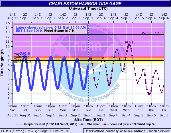
What: The greatest concern from Dorian continues to be storm surge, with the potential of 4-7′ of surge in a reasonable worst-case scenario. Major coastal flooding — with tides perhaps on the order of 8-10′ MLLW — will be likely with the Wednesday high tide cycles. This will cause significant problems in much of downtown Charleston, including issues with structures flooding. The peak storm tide could come overnight! Be ready to head to higher ground at short notice on Wednesday night.
To put this in context, it is very likely we are going to set another top ten tide in the harbor. If 10.3′ were to verify, it would be the second highest on record, only behind Hugo’s 12.52′ in 1989.

When: A Storm Surge Warning is in effect. Peak surge will be realized on Wednesday into early Thursday morning. Much of downtown will be impassable during this time! Once the storm moves north, winds will reverse and the tide will blow out.
Rainfall


What: Heavy rainfall, especially on top of storm surge, is going to pose a significant threat for flash flooding in coastal communities. I expect that we will see downtown Charleston flood for an extended period of time given expected surge and rainfall near 7-10″ (with locally higher amounts). There is a good probability of flash flooding on Wednesday and again early Thursday.
When: Rainfall looks to begin in bands Wednesday morning. The heaviest rain squalls will occur later in the day on Wednesday, overnight, and into much of Thursday before tapering off in the evening as Dorian departs.
Update September 3 @ 4PM: A Flash Flood Watch will go into effect Wednesday morning through Friday morning, owing to the serious risk of flooding from Dorian.
Winds
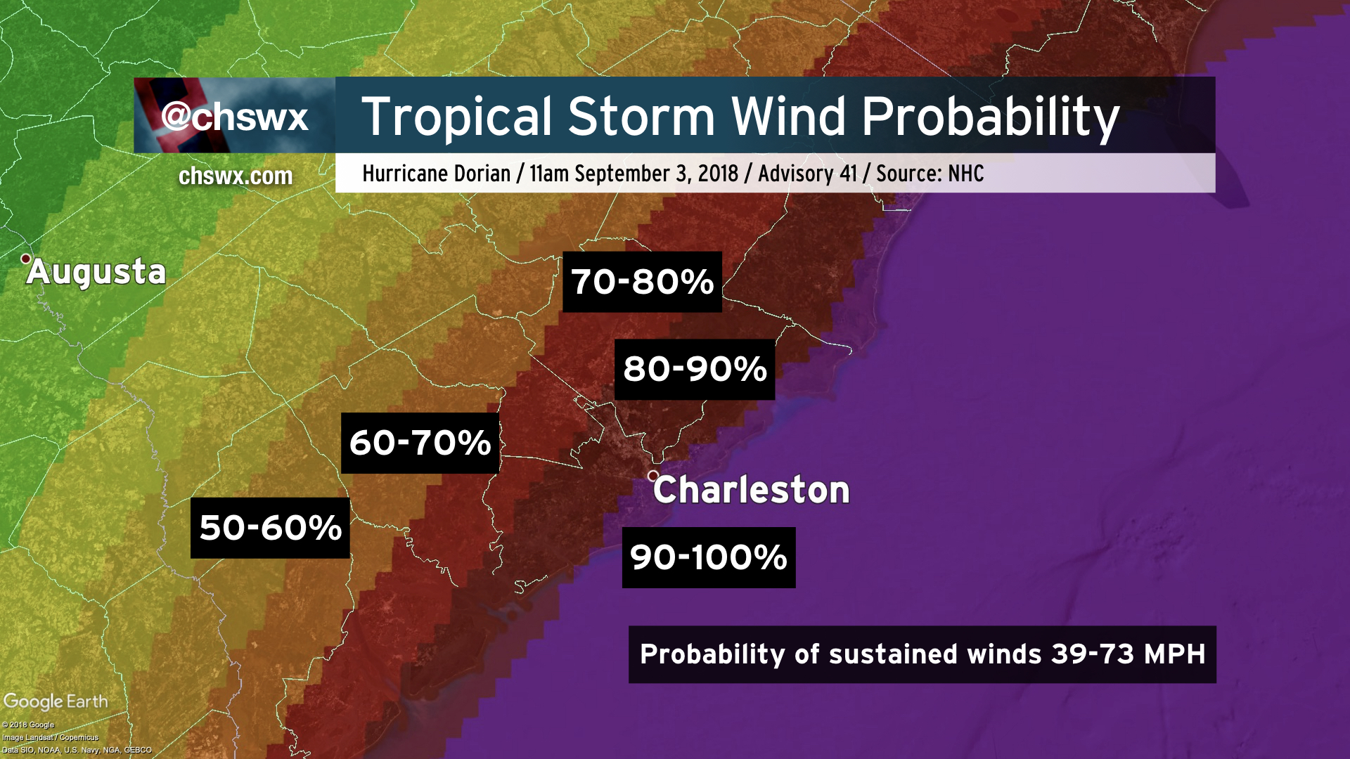
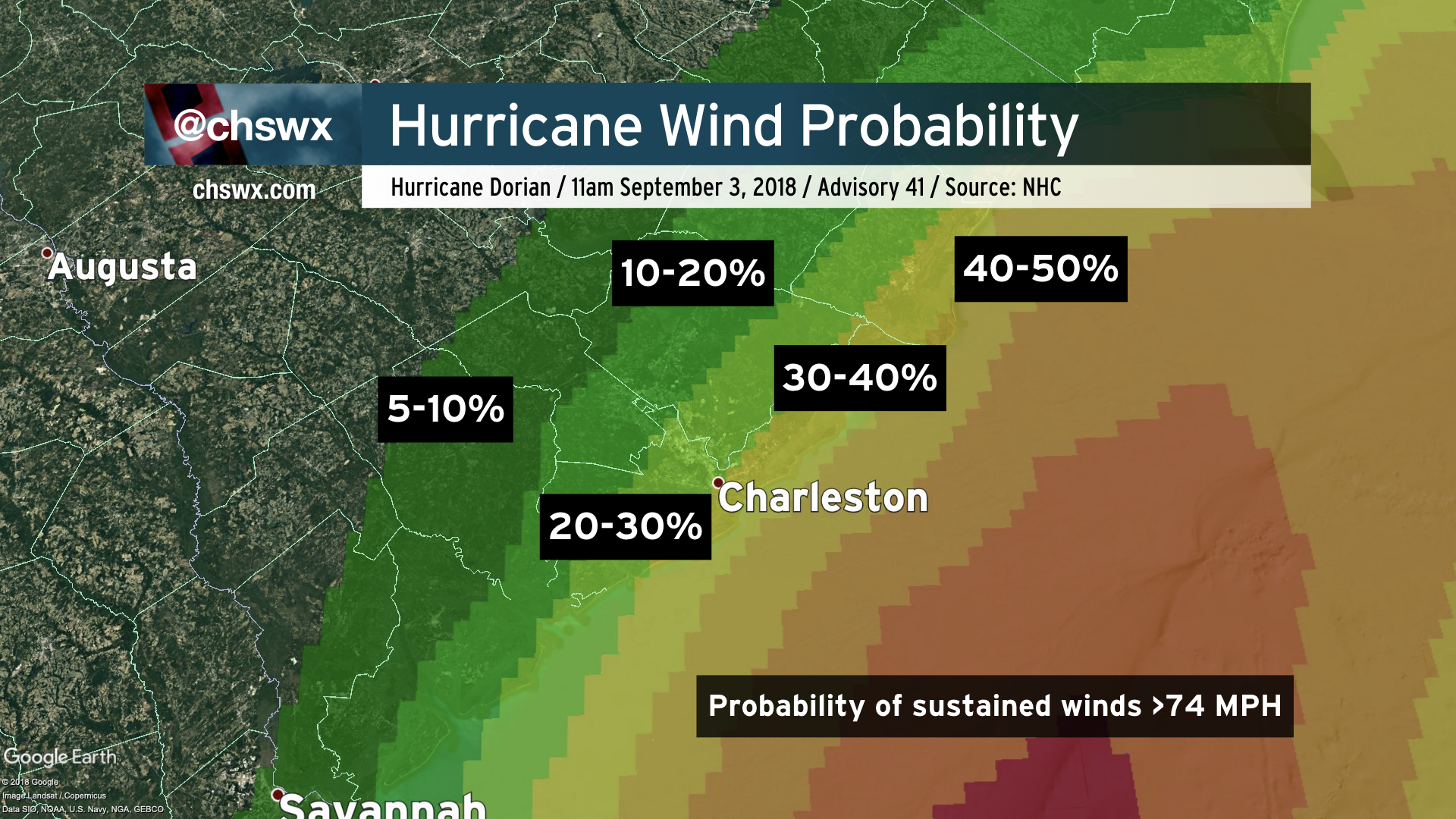
What: Winds to hurricane force (74+ MPH) will be possible along the coast, with tropical storm-force winds (39-73 MPH) a near certainty. Further inland, tropical storm winds are likely, with hurricane force gusts possible. The wind field will continue to expand, as well, meaning strong winds will come further inland over time. Trees and power lines are likely to come down, causing power outages and travel impediments.
When: The worst winds look to begin after sunset on Wednesday. Seems as if Wednesday night is going to be a fairly windy night — parents, take note as this could be somewhat concerning to young ones. Strong winds should continue through Thursday evening before abating as Dorian’s center pulls away.
Tornadoes
What: While we won’t be in the most favorable quadrant of the storm for tornadoes, there is the potential to see a tornado or two in outer rain bands as Dorian approaches the area. A tornado event like Irma is not expected.
When: Wednesday afternoon and evening.
Next update
The next track and intensity forecast comes out at 5 PM.
Follow my Charleston Weather updates on Mastodon, Bluesky, Instagram, Facebook, or directly in a feed reader. Do you like what you see here? Please consider supporting my independent, hype-averse weather journalism and become a supporter on Patreon for a broader look at all things #chswx!